Georgia State Route 124
| ||||
|---|---|---|---|---|
 | ||||
| Route information | ||||
| Maintained by GDOT | ||||
| Length: | 51.2 mi[1] (82.4 km) | |||
| Major junctions | ||||
| Southwest end: |
| |||
|
| ||||
| Northeast end: |
| |||
| Location | ||||
| Counties: | DeKalb, Gwinnett, Barrow, Jackson | |||
| Highway system | ||||
| ||||

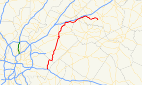
State Route 124 (SR 124) is a 51.1-mile-long (82.2 km) state highway that runs southwest-to-northeast through portions of DeKalb, Gwinnett, Barrow, and Jackson counties in the north-central part of the U.S. state of Georgia.
Route description
SR 124 begins at an intersection with I-20/US 278/SR 12 in Lithonia, in DeKalb County. To the northeast, it crosses into Gwinnett County and, immediately, crosses over the Yellow River. Southwest of Snellville, it meets SR 264. In town, it intersects US 78/SR 10 and then, the Ronald Reagan Parkway. On the southwestern edge of Lawrenceville is Sugarloaf Parkway. Farther into town, it intersects SR 20. Then, US 29/SR 8 join the road in a concurrency to the west. A short distance later, SR 124 splits to the north, and almost immediately, joins SR 20 concurrently to an interchange with SR 316 (University Parkway). A short distance later, SR 124 splits off to the northeast. From here until SR 211(Old Winder Highway, also about where Braselton Town Limits begin), the road name is changed to Braselton Highway. Northwest of Dacula, it meets SR 324. Farther to the northeast, the highway crosses into Barrow County. After an intersection with SR 211, it enters Jackson County. A few miles later is Braselton. There, it meetsSR 53. It curves to the southeast to SR 332. The road heads westerly until it meets its northeastern terminus, an intersection with SR 11 in the southwestern part of Jefferson.
Major intersections
| County | Location | mi[1] | km | Destinations | Notes |
|---|---|---|---|---|---|
| DeKalb | Lithonia | 0.0 | 0.0 | Western terminus Southern end of US 278 and SR 12 concurrencies | |
| 0.1 | 0.16 | Northern end of US 278 and SR 12 concurrencies | |||
| Gwinnett | | 10.1 | 16.3 | Eastern terminus of SR 264 | |
| Snellville | 13.6 | 21.9 | |||
| Lawrenceville | 20.1 | 32.3 | |||
| 20.9 | 33.6 | Western end of US 29/SR 8 concurrency | |||
| 21.3 | 34.3 | Eastern end of US 29/SR 8 concurrency; western end of SR 20 concurrency | |||
| 22.8 | 36.7 | ||||
| | 29.3 | 47.2 | |||
| Barrow | Braselton | 38.2 | 61.5 | ||
| Jackson | 39.3 | 63.2 | Unnamed bridge | Crossing over the Mulberry River | |
| 41.1 | 66.1 | Western end of SR 53 concurrency | |||
| 41.1 | 66.1 | Eastern end of SR 53 concurrency | |||
| | 43.9 | 70.7 | Southern terminus of SR 60 | ||
| | 45.2 | 72.7 | |||
| Jefferson | 51.0 | 82.1 | Eastern terminus | ||
1.000 mi = 1.609 km; 1.000 km = 0.621 mi
| |||||
See also
-
.svg.png) Georgia (U.S. state) portal
Georgia (U.S. state) portal -
 U.S. Roads portal
References
- 1 2 Google (July 7, 2013). "Route of SR 124" (Map). Google Maps. Google. Retrieved July 7, 2013.
External links
-
 Media related to Georgia State Route 124 at Wikimedia Commons
 - Georgia Roads (Routes 121 - 140)
- Georgia State Route 124 on State-Ends.com