Oklahoma State Highway 52
| ||||
|---|---|---|---|---|
 | ||||
| Route information | ||||
| Maintained by ODOT | ||||
| Section 1 | ||||
| Length: | 4.06 mi[1] (6.53 km) | |||
| South end: | Hanna | |||
| North end: |
| |||
| Section 2 | ||||
| Length: | 16.46 mi[2] (26.49 km) | |||
| South end: |
| |||
| North end: |
| |||
| Highway system | ||||
| ||||

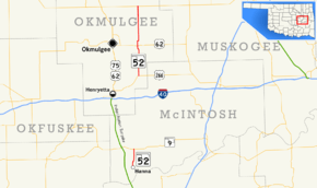
State Highway 52 (abbreviated SH-52) is two once-connected highways in the U.S. state of Oklahoma. There are no lettered spur routes from either of them.
Route description
Southern section
The southern SH-52 is a short, 4.06 miles (6.53 km)[1] state highway in McIntosh County, Oklahoma. It connects State Highway 9 to the town of Hanna.
Northern section
The northern SH-52 runs for 16.46 miles (26.49 km)[2] from US-266 northeast of Grayson to SH-16. Along the way it intersects US-62 near Morris.
History
At one time, at least as recently as 1972, the two sections of SH-52 were connected by a dirt section running from SH-9 to US-266. This section has since been decommissioned. [3]
Junction list
Southern section
The entire route is in McIntosh County.
| Location | mi[1] | km | Destinations | Notes | |
|---|---|---|---|---|---|
| Hanna | 0.00 | 0.00 | Countryside Road | Southern terminus | |
| | 4.06 | 6.53 | Northern terminus | ||
| 1.000 mi = 1.609 km; 1.000 km = 0.621 mi | |||||
Northern section
The entire route is in Okmulgee County.
| Location | mi[2] | km | Destinations | Notes | |
|---|---|---|---|---|---|
| | 0.00 | 0.00 | Southern terminus | ||
| Morris | 7.05 | 11.35 | |||
| | 16.46 | 26.49 | Northern terminus | ||
| 1.000 mi = 1.609 km; 1.000 km = 0.621 mi | |||||
References
- 1 2 3 Oklahoma Department of Transportation (2010-01-01). Control Section Maps: McIntosh County (PDF) (Map) (2010–2011 ed.). Scale not given. Oklahoma City: Oklahoma Department of Transportation. Retrieved November 3, 2012.
- 1 2 3 Oklahoma Department of Transportation (2010-01-01). Control Section Maps: Okmulgee County (PDF) (Map) (2010–2011 ed.). Scale not given. Oklahoma City: Oklahoma Department of Transportation. Retrieved November 3, 2012.
- ↑ McMahon, Martin. Terminus: SH-52 (North). Roadklahoma. 10 December 2002. URL accessed 28 May 2006.
This article is issued from Wikipedia - version of the 10/22/2016. The text is available under the Creative Commons Attribution/Share Alike but additional terms may apply for the media files.