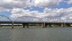
State Highway 29 Bridge at the Colorado River
|
State Highway 29 Bridge at the Colorado River | |
 | |
 SH 29 Bridge at the Colorado River  SH 29 Bridge at the Colorado River | |
| Location |
|
|---|---|
| Coordinates | 30°44′53″N 98°56′54″W / 30.74806°N 98.94833°WCoordinates: 30°44′53″N 98°56′54″W / 30.74806°N 98.94833°W |
| Built | 1937 |
| Architect | Austin Bridge Co |
| NRHP Reference # | 96001116[1] |
| Added to NRHP | October 10, 1996 |
State Highway 29 Bridge at the Colorado River is located in both Burnet and Llano counties in the U.S. state of Texas, between Buchanan Dam and Inks Lake . It is also known as Inks Lake Bridge, and was added to the National Register of Historic Places listings in both counties on October 10, 1996.[2] The 1,379.0 ft truss bridge was planned by the Texas Highway Department in 1929. Construction was completed by the Austin Bridge Company in 1937 at a cost of $188,000. United States Secretary of the Interior Harold Ickes and Texas Highway Commissioner Robert Lee Bobbitt were featured speakers during the dedication ceremony.[3] A new four-lane vehicular bridge was built in 2005,[4] and the old SH 29 Bridge is currently open only to pedestrians.[5]
See also
- Inks Lake
- National Register of Historic Places listings in Burnet County, Texas
- National Register of Historic Places listings in Llano County, Texas
References
- ↑ National Park Service (2010-07-09). "National Register Information System". National Register of Historic Places. National Park Service.
- ↑ "TX 29 Colorado River Bridge". Bridgehunter.com. Retrieved July 26, 2013.
- ↑ "Bridge at the Colorado River, State Highway 29". Texas Historical Commission. Retrieved July 26, 2013.
- ↑ "NBI Structure Number:140270015005048". The National Bridge Inventory Database. Nationalbridges.com. Retrieved July 26, 2013.
- ↑ "Inks Lake Bridge Over the Colorado". Texas Escapes – Blueprints For Travel, LLC. Retrieved July 26, 2013.
| Topics | |
|---|---|
| Lists by states |
|
| Lists by insular areas | |
| Lists by associated states | |
| Other areas | |
| |