Stary Las, Opole Voivodeship
For other places with the same name, see Stary Las.
| Stary Las | |
|---|---|
| Village | |
|
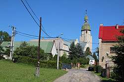
Church in Stary Las | |
 Stary Las | |
| Coordinates: 50°23′3″N 17°24′19″E / 50.38417°N 17.40528°E | |
| Country |
|
| Voivodeship | Opole |
| County | Nysa |
| Gmina | Głuchołazy |
| Highest elevation | 265 m (869 ft) |
| Lowest elevation | 258 m (846 ft) |
| Population | 720 |
Stary Las [ˈstarɨ ˈlas] (German Altewalde) is a village in the administrative district of Gmina Głuchołazy, within Nysa County, Opole Voivodeship, in south-western Poland, close to the Czech border.[1] It lies approximately 9 kilometres (6 mi) north of Głuchołazy, 11 km (7 mi) south-east of Nysa, and 49 km (30 mi) south-west of the regional capital Opole.
Before 1945 the area was part of Germany (see Territorial changes of Poland after World War II).
The village has a population of 720.
References
| Town and seat |  | |
|---|---|---|
| Villages | ||
Coordinates: 50°23′3″N 17°24′19″E / 50.38417°N 17.40528°E
This article is issued from Wikipedia - version of the 1/4/2015. The text is available under the Creative Commons Attribution/Share Alike but additional terms may apply for the media files.