Stapleford Abbotts
| Stapleford Abbotts | |
 Church of St Mary Grade II architecturally listed |
|
 Tysea Hill, Stapleford Abbots |
|
 Stapleford Abbotts |
|
| Area | 9.57 km2 (3.69 sq mi) |
|---|---|
| Population | 959 (2001) 1,008 (2001)[1] |
| – density | 100/km2 (260/sq mi) |
| OS grid reference | TQ505955 |
| – London | 16.2 mi (26.1 km) SW |
| Civil parish | Stapleford Abbotts |
| District | Epping Forest |
| Shire county | Essex |
| Region | East |
| Country | England |
| Sovereign state | United Kingdom |
| Post town | ROMFORD |
| Postcode district | RM4 |
| Dialling code | 01708 |
| Police | Essex |
| Fire | Essex |
| Ambulance | East of England |
| EU Parliament | East of England |
| UK Parliament | Brentwood and Ongar |
| Website | www |
Coordinates: 51°38′17″N 0°09′50″E / 51.638°N 0.164°E
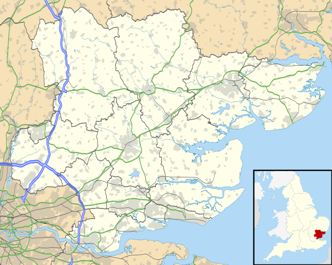
Stapleford Abbotts [n 1] is a village and civil parish in the Epping Forest district of Essex, approximately 9 km (5.6 mi) SW of Ongar, 7 km (4.3 mi) N of Romford and 8 km (5.0 mi) SSE of Epping. The whole parish is within the M25 motorway. The village covers 957 hectares and had a population of 959 in 2001,[3] increasing to 1,008 at the 2011 Census.[1]
History
The origins of the parish’s name are because the principal manor was held by the Abbey of Bury St Edmunds from before the Norman Conquest to the Dissolution. A story is recorded in the abbey's registers that the lord of the manor was miraculously cured of a lingering illness in 1013 by the body of St Edmund as it passed by on its way back to Bury Abbey from London. In gratitude for being cured he gave the manor to the abbey, either then or some time later.[2]
The population rose from 320 in 1801 to 507 in 1831, then fluctuated within that range until 1921 when it was 391. In the 20th century there has been a gradual increase with the building of houses from the 1930s onwards (in 1951 the population was 731).[4]
Historically Stapleford Abbotts was included in the hundred of Ongar. It formed part of the Ongar Rural District Council from 1894 until that authority was absorbed into Epping and Ongar Rural District Council in 1955. Following local government reorganisation in 1974 it has been part of Epping Forest District. The present civil parish retains largely the same boundaries as the ancient parish as it existed prior to the mid-19th century.
Geography
The parish is mostly rural and agricultural with a scattering of farms and cottages, much of it is Metropolitan Green Belt protected land. The northern boundary of the parish is formed by the River Roding and the remainder of the parish is crossed by a number of streams that feed into it or form the headwater of the River Rom. As a result of geology the terrain is hilly and 28–90m above sea level (AOD) with most development at between 35m and 80m.[5]
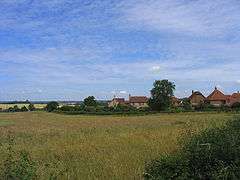
The village itself consists of a straggle of mostly 20th-century housing stretching for about a mile along the elevated Romford to Ongar road from the boundary with Havering-atte-Bower. The medieval church (largely rebuilt in the 19th century) is situated in a relatively isolated position a further mile away from what is now the village, reflecting the fact that there was no single nucleus of settlement until the 20th century.[4][6]
Aside from the village of Stapleford Abbotts the parish includes the hamlets of Bournebridge, Nuper's Hatch and a small part of Passingford Bridge. Two places use the village's name outside of it, Stapleford Flight Centre which provides sightseeing flights and Stapleford Abbotts Golf Course (see below).[7]
 |
Theydon Mount | Stapleford Tawney | across part of Navestock Kelvedon Hatch |
|
| Lambourne | |
Navestock | ||
| ||||
| | ||||
| across Havering Park and Hainault Forest Hainault |
Havering-atte-Bower | Harold Hill |
Localities
Bournebridge
Adjoining a farm on the main street to the south is the Bournebridge hamlet. The bridge called Bourne Bridge crosses the Bourne Brook and it subsequently becomes the River Rom.[8] One listed building is in the hamlet, architecturally at Grade II, named The School House.[9] Fewer than 20 homes and farms make up the hamlet.[5]
Nuper's Hatch
This hamlet ranges from 60–82m AOD compared to the village centre's 55m AOD average and is centred on Nuper's and Lyng's Farm and consists of at least 60 properties, in particular the neighbourhood and linear development of Tysea Hill. On the Tysea Hill ridge is Stapleford Abbotts Golf Course which is across an almost straight north-south divide in the Borough of Brentwood.[5] Six other farms adjoin the main road here using a hilly terrain and Curtismill Green itself is in the parish along with a few cottages, including grade II listed Honeysuckle Cottage,[10] however most of that hamlet is in Navestock.
Transport
Buses are limited in this area, served by one main route, Route 375. Route 575 also passes through the area but this only has one return journey per day.
| Route Number | Route | Via | Operator | Operational Details |
|---|---|---|---|---|
| 375 |
Passingford Bridge to Romford Station |
Havering-atte-Bower, Collier Row. | Arriva Southend . | Mon-Sat every 90 minutes. London Buses service. Times |
| 575 |
Epping High Street to Lakeside Shopping Centre. | Debden, Abridge, Havering-atte-Bower, Collier Row, Romford |
Blue Triangle | Mon-Fri 1 return journey. Times |
See London Bus Routes and Essex Bus Routes.
The nearest railway station is at Romford. There are frequent main line services from its station to London and East Anglia. Both routes 375 and 575 can be used to reach the station.
Notes and References
- Notes
- References
- 1 2 "Civil Parish population 2011". Neighbourhood Statistics. Office for National Statistics. Retrieved 7 September 2016.
- 1 2 British History — Access to historic documents and research from the University of Portsmouth and History of Parliament Trust. A History of the County of Essex: Volume 4: Ongar Hundred (1956), pp. 223-28, Stapleford Abbots: Manors. Accessed: 7 September 2007
- ↑ Epping Forest District Council – Stapleford Abbotts Parish Profile
- 1 2 British History. A History of the County of Essex: Volume 4: Ongar Hundred (1956), pp. 222-23, Stapleford Abbots: Introduction. Date accessed: 7 September 2007
- 1 2 3 Ordnance survey website
- ↑ St Mary's Church — Grade II listing Historic England. "Details from listed building database (1165922)". National Heritage List for England.
- ↑ Stapleford Flight Centre
- ↑ Essex County — Official Map
- ↑ The Old School House — Grade II listing Historic England. "Details from listed building database (1165920)". National Heritage List for England.
- ↑ Honeysuckle Cottage — Grade II listingHistoric England. "Details from listed building database (1165956)". National Heritage List for England.