Stanstead Lock
 The lock, lock-keeper's house and swing-bridge | |
| Waterway | River Lee Navigation |
|---|---|
| County | Hertfordshire |
| Maintained by | British Waterways |
| Operation | Manual |
| Length | 85 feet (25.9 m) |
| Width | 16 feet (4.9 m) |
| Fall | 8 feet 4 inches (2.5 m) |
| Distance to Bow Creek | 21.5 miles (34.6 km) |
| Distance to Hertford Castle Weir | 4.8 miles (7.7 km) |
| Coordinates | 51°47′27″N 0°00′00″E / 51.790953°N 0.000131°ECoordinates: 51°47′27″N 0°00′00″E / 51.790953°N 0.000131°E |
Stanstead Lock (No4) is a lock on the River Lee Navigation close to the villages of Stanstead Abbotts and St Margarets. The lock which incorporates a rare example of a swing-bridge, has the reputation of being one of the country's most difficult to negotiate.[1]
Location
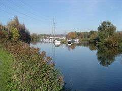
Stanstead marina viewed from the south. The Stanstead mill stream merges with the Navigation in the foreground
The lock-keeper's house is located on an island formed by a section of the River Lee Flood Relief Channel that flows through the automatic sluice gate adjacent to the lock.
Located to the south of the lock is the Stanstead marina.
Public transport
St Margarets (Hertfordshire) railway station
External links
| Next lock upstream | River Lee Navigation | Next lock downstream |
| Hardmead Lock 1.0 mile |
Stanstead Lock Grid reference: TL3792812197 |
Feildes Weir Lock 2.5 miles |
References
- ↑ London canals- Stanstead lock Retrieved 27 June 2008
This article is issued from Wikipedia - version of the 6/23/2015. The text is available under the Creative Commons Attribution/Share Alike but additional terms may apply for the media files.