Stainton, Richmondshire


Coordinates: 54°21′51″N 1°50′15″W / 54.364213°N 1.837617°W
Stainton is a hamlet and civil parish in the Richmondshire district of North Yorkshire, England. It is located on the border of the Yorkshire Dales, with a population of 54. At the 2011 Census the population of the civil parish remained less than 100. Information is included in the parish of Hudswell. It lies close to the army training camp of Wathgill.
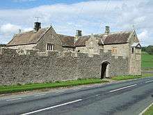
Walburn Hall
A little over a mile to the south-east, Walburn Hall is a fortified house probably dating from the 12th century but much altered in the 15th and 16th centuries.[1]
References
- ↑ Historic England. "Walburn Hall (50954)". PastScape. Retrieved 20 March 2015.
External links
![]() Media related to Stainton, Richmondshire at Wikimedia Commons
Media related to Stainton, Richmondshire at Wikimedia Commons
This article is issued from Wikipedia - version of the 2/6/2016. The text is available under the Creative Commons Attribution/Share Alike but additional terms may apply for the media files.