Kirkoswald, Cumbria
| Kirkoswald | |
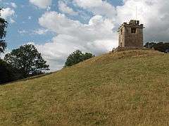 The belltower, built on the hill above the church so that villagers could hear the bells |
|
 Kirkoswald |
|
| Population | 901 (2011)[1] |
|---|---|
| OS grid reference | NY355541 |
| Civil parish | Kirkoswald |
| District | Eden |
| Shire county | Cumbria |
| Region | North West |
| Country | England |
| Sovereign state | United Kingdom |
| Post town | PENRITH |
| Postcode district | CA10 |
| Dialling code | 01768 |
| Police | Cumbria |
| Fire | Cumbria |
| Ambulance | North West |
| EU Parliament | North West England |
| UK Parliament | Penrith and The Border |
Coordinates: 54°45′55″N 2°41′37″W / 54.765183°N 2.693673°W
The village, civil parish and former market town of Kirkoswald lies in the Lower Eden Valley of Cumbria, formerly Cumberland, about 9 miles (14 km) from Penrith. The village is usually referred to locally as KO.

The village's name means Church of St Oswald and the parish church is dedicated to Saint Oswald, King of Northumbria. The body of Oswald is believed to have been taken through the village. The church lies on the southern edge of the village overlooking the River Eden close to the bridge which connects Kirkoswald to Lazonby. St Oswald's Church is unique in having a 19th-century bell tower on top of the hill 200 yards from the church itself. Parts of the church date from the 12th century, the chancel being added in 1523, when the "College" was founded by Thomas Dacre, 2nd Baron Dacre and his wife.[2] A sacred spring lies under the nave of the church, and a well is found on the west wall.[3]
One of Kirkoswald's most splendid buildings is the "College", its name recalling the days when St Oswald's Church was a collegiate church. Originally built in 1450 as a Pele Tower it became home to the Fetherstonhaugh family, after dissolution in 1547, who previously lived at Featherstone Castle in Northumberland.
The village consists mainly of one main street rising up a steep hill passing through a market place on which the village's two pubs (the "Crown Inn" and the "Fetherston Arms") are situated. A third pub, the Black Bull, which at one time won awards for its food, overlooked the square but this closed in the early 1990s.
The village also has one shop which houses a post office, a Methodist church and a well-attended primary school. Until quite recently there were further shops including a butcher and a branch of the Midland Bank.
Given its market charter in the 13th century,[3] the village held a market before it was resited at Lazonby and Kirkoswald railway station[4] after the creation of the Settle to Carlisle Railway Line in 1876.[5]
Kirkoswald is within the Eden District of Cumbria. Included in the parish are the nearby village of Renwick and the hamlets of Staffield, High Bankhill, Parkhead and Scales. From 1866 to 1934 Renwick and Staffield were separate civil parishes. The parish council meets at the village hall in Kirkoswald's former market square.
Governance
An electoral ward in the same name exists. This ward stretches north to Ainstable with a total population taken at the 2011 census of 1,471.[6]
See also
References
- ↑ "Parish population 2011". Retrieved 21 June 2015.
- ↑ Kirkoswald - St Oswald's Church Church
- 1 2 Kirkoswald Cumbria
- ↑ Kirkoswald
- ↑ The Settle-Carlisle Railway
- ↑ "Ward population 2011". Retrieved 21 June 2015.
External links
![]() Media related to Kirkoswald, Cumbria at Wikimedia Commons
Media related to Kirkoswald, Cumbria at Wikimedia Commons
Cumbria Portal | |
| Boroughs or districts | |
| Major settlements |
|
| Topics | |