North Cornwall Railway
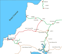
The North Cornwall Railway was a railway line running from Halwill in Devon to Padstow in Cornwall via Launceston, Camelford and Wadebridge, a distance of 49 miles 67 chains (80.21 km). Opened in the last decade of the nineteenth century, it was part of a drive by the London and South Western Railway (LSWR) to develop holiday traffic to Cornwall. The LSWR had opened a line connecting Exeter with Holsworthy in 1879,[1] and by encouraging the North Cornwall Railway it planned to create railway access to previously inaccessible parts of the northern coastal area.
"There are few more fascinating lines than the one which leads to North Cornwall from Okehampton"[2] says T.W.E. Roche in his popular tribute to the network of railway lines operated by the London and South Western Railway (LSWR) in North and West Devon and North Cornwall.
History
First railways
| North Cornwall Railway | ||||||||||||||||||||||||||||||||||||||||||||||||||||||||||||||||||||||||||||||||||||||||||||||||||||||||||||||||||||||||||||||||||||||||||||||||||||||||||||||||||||||||||||||
|---|---|---|---|---|---|---|---|---|---|---|---|---|---|---|---|---|---|---|---|---|---|---|---|---|---|---|---|---|---|---|---|---|---|---|---|---|---|---|---|---|---|---|---|---|---|---|---|---|---|---|---|---|---|---|---|---|---|---|---|---|---|---|---|---|---|---|---|---|---|---|---|---|---|---|---|---|---|---|---|---|---|---|---|---|---|---|---|---|---|---|---|---|---|---|---|---|---|---|---|---|---|---|---|---|---|---|---|---|---|---|---|---|---|---|---|---|---|---|---|---|---|---|---|---|---|---|---|---|---|---|---|---|---|---|---|---|---|---|---|---|---|---|---|---|---|---|---|---|---|---|---|---|---|---|---|---|---|---|---|---|---|---|---|---|---|---|---|---|---|---|---|---|---|---|
Legend | ||||||||||||||||||||||||||||||||||||||||||||||||||||||||||||||||||||||||||||||||||||||||||||||||||||||||||||||||||||||||||||||||||||||||||||||||||||||||||||||||||||||||||||||
| ||||||||||||||||||||||||||||||||||||||||||||||||||||||||||||||||||||||||||||||||||||||||||||||||||||||||||||||||||||||||||||||||||||||||||||||||||||||||||||||||||||||||||||||
In the nineteenth century, Padstow was an important fishing port, but it was hampered by lack of land communication with its markets. The Bodmin and Wadebridge Railway opened in 1834, but it limited its horizons to connecting the harbour at Wadebridge to the immediate hinterland.
Trunk railway connection reached Cornwall with the opening of the Cornwall Railway in 1859, allied with the associated companies which formed the alliance led by the Great Western Railway, whose lines used the broad gauge. The Cornwall Railway ran east to west in the southern part of the county, and it had exhausted its financial resources in building its line through the difficult terrain. The struggle to achieve dominance in Cornwall had been fierce and the rival London and South Western Railway (LSWR) had the intention of having a line in the county; in 1847 it had purchased the Bodmin and Wadebridge Railway,[3][4] at a time when the nearest section of its own network was at Bishopstoke (Eastleigh). Finding the necessity of concentrating its resources further east, it had been unable to make progress towards connecting Cornwall into its system.
The LSWR reaches Devon
Through the medium of nominally independent local companies, the LSWR had reached Lidford (now spelt Lydford) in Devon in 1874, giving it access to Plymouth over the South Devon Railway, and in 1879 it built a branch from Meldon Junction, west of Okehampton, to Holsworthy in north west Devon.
Now the LSWR had the opportunity to enter Cornwall, and to connect with its isolated Bodmin and Wadebridge line. A North Cornwall Railway company, supported by the LSWR, was formed to develop the northern part of the Cornish peninsula; its line was to leave the Holsworthy line (which was later extended to become the Okehampton to Bude Line) at Halwill and continue through Launceston to Wadebridge. The prospectus of the North Cornwall company indicated that a further extension of 24 miles (39 km) would be required to bring the railway from Wadebridge to the county town of Truro.
Opening in stages
The North Cornwall Railway obtained its authorising Act of Parliament on 18 August 1882, but money was scarce and construction was slow, so it was not until 21 July 1886 that the first section opened, and the line was completed in 1899. (In fact to facilitate raising capital, the Company was segmented into several sections for financial purposes; the total authorised capital was £660,000 with borrowing powers of £220,000.)[5] The LSWR was to work the line for 55% of gross receipts.[6]
The line was opened in stages:
- Halwill to Launceston; 14 miles 57 chains (23.68 km); 21 July 1886
- Launceston to Tresmeer; 7 miles 75 chains (12.77 km); 28 July 1892[note 1]
- Tresmeer to Camelford; 9 miles 26 chains (15.01 km); 14 August 1893
- Camelford to Delabole; 2 miles 29 chains (3.8 km); 18 October 1893
- Delabole to Wadebridge; 10 miles 68 chains (17.46 km); 1 June 1895
- Wadebridge to Padstow; 5 miles 52 chains (9.09 km); 27 March 1899.[4][7]
The Great Western Railway (GWR) already had a station at Launceston, opened in 1865, and the North Cornwall Railway station was built adjacent to it. At Wadebridge, the line joined with the Bodmin and Wadebridge line; the original station had been expanded when the GWR line from Bodmin was opened in 1888.
Commercial potential
The fishing activity at Padstow had long been declining, and the LSWR had hopes of reviving it. Their wishes were realised and a substantial increase of fish tonnage carried was experienced over the first years; a special connection to the fish quay had been provided. Tourist and holiday passenger traffic was also sought, as by the end of the nineteenth century this business was well established at comparable locations. There was a large slate quarry at Delabole, at the time said to be the largest man-made excavation in the world[4] and considerable traffic was derived from that.
However apart from Launceston and Wadebridge the very long single-track line served only small rural communities, and never achieved the importance that its promoters had hoped for. Fish traffic and ice for the ships[7] were always important commodities on the line, as was the seasonal holidaymaker traffic for Padstow and several resorts served indirectly by the railway.
Takeover by the LSWR
Worked throughout its existence by the LSWR, the North Cornwall Line was dependent on the larger company, and in 1894 terms were agreed for a sale to the LSWR:
On to Penzance?
In 1894, with rapid progress being made in building the line, a parliamentary notice was issued for a line from Padstow to Newquay and Truro, and from there with running powers over the GWR to Falmouth and Penzance.[4] However this was an aspiration for which there was no possibility of raising the necessary finance,[8] and the proposal came to nothing, but the GWR were concerned at this planned penetration, and it is said[4] that this prompted the scheme to build a line from Truro to Newquay. This became the Atlantic Coast Line, which links the GWR mainline at Par to Newquay. In 1905 powers were granted to provide a line to Newquay diverging in the vicinity of Bodmin Road. Proposals for light railways in the country between Padstow and Newquay continued until 1911, but none came to anything.
Padstow harbour improvements
In 1911 a scheme was developed to improve the fishing harbour arrangements at Padstow; this was supported by the government and the LSWR; the Company alone spent £10,350 on the dock wall and sidings and sheds, and took up £30,000 of the Harbour Commissioners' bonds. The work was completed by 1920, by which time the LSWR was the dominant partner in the operation of the harbour.[9]
Financial reconstruction
The building of the North Cornwall Line had been undertaken by four different financial entities for reasons of raising finance at a difficult time. In 1912 the LSWR chairman, Herbert Walker, proposed a capital reconstruction under which a single North Cornwall Railway Leased Line stock would be created from the four subsidiaries; £825,000 of capital was transferred in this way, the arrangement receiving Parliamentary authority on 15 August 1913.[9]
Grouping of the railways, and nationalisation
Under the terms of the Railways Act 1921, the railway companies of Great Britain were to be amalgamated into four "groups"; the new Southern group was to include the LSWR (as a "constituent"), and the North Cornwall Railway was to be absorbed: the Company was still in existence as an entity although the line was worked as an intrinsic part of the LSWR. This process of "grouping" took practical effect at the beginning of 1923, although a number of technical requirements resulted in the official transfer dates varying.[9]
Under the terms of the Transport Act 1947 the railways of Great Britain passed into national ownership at the beginning of 1948.
Closure
Throughout its existence the North Cornwall line had operated against the odds, its long line serving sparsely populated and relatively unproductive terrain. As the costs of unproductive railway operation came into focus following the Beeching Report, the line had only its romantic appeal to offer, with even the highly seasonal summer holiday traffic falling away in the face of road transport and more attractive destinations. It closed on 3 October 1966, the Wadebridge to Padstow section continuing to be served by Bodmin trains until it too closed on 28 January 1967.[10]
Train services
The thin population meant that little intermediate traffic was generated, and a passenger service of four or five daily trains was operated almost throughout the life of the line.
The route between Launceston and Padstow was not designed for speed. The single line route required several sections at a gradient of 1 in 73 to allow for the rise from near Sea Level at Padstow to a summit at 860 feet above Sea Level between Camelford and Otterham and the line constantly curved, typically with a radius of 30 chains, in order to follow the contours and avoid costly earthworks. The result was a typical journey from Halwill to Padstow that occupied 90 to 100 minutes down and up to 110 minutes in the up direction. These times were reduced over the years with more powerful locomotives so that by the 1940s journey times between Launceston and Padstow were typically 80 minutes in the down direction and 90 minutes in the up. The maximum speed permitted on the North Cornwall line was 55 mph.[11]
The 1938 Bradshaw's Railway Guide[12] shows five down and six up trains a day (Monday to Friday) on the line, plus a first up train from Launceston to Halwill and a last up train from Padstow to Launceston, and a last down train from Halwill to Launceston. All the trains called at all stations with the exception of the Atlantic Coast Express, the 11:00 from Waterloo, which ran non-stop Exeter St Davids to Halwill, then Launceston, Otterham, Camelford, Delabole, Port Isaac Road and Wadebridge, arriving in Padstow at 4:24 after a 260-mile (420 km) journey. The train conveyed a restaurant car throughout. The Saturday service was similar, although congestion earlier in the journey meant a slightly slower journey. There was no Sunday service.
Tender engines were preferred on the line, the Adams Jubilee class being dominant at first, supplanted by the T9 class 4-4-0 being dominant in the Edwardian era. Until the mid-1940s the weight restriction over Meldon Viaduct and the short turntable at Padstow prevented anything larger than the Southern Railway mixed traffic 2-6-0 types from working over the line. However, after the turntable was replaced, the Bulleid Light Pacific locomotives were able to use the line.[4] On summer Saturdays in the 1950s, some trains loaded to ten coaches, and in that era the Standard 2-6-4T class came into use on the line.[10]
While the GWR could easily serve major Devon and Cornwall resorts on its main line and branches, the rugged North Cornwall terrain prevented this. However Southern National omnibus connections gave journey options: Tintagel and Boscastle had good connections from Camelford, Newquay from Wadebridge, and Bedruthan and Trevone Bay from Padstow. Otterham is marked in the timetable as being the "Station for Wilsey Down and Davidstow (2½ miles) and Crackington Haven (5 miles)".
By 1964[13] the passenger service had declined to four trains a day plus a Halwill to Launceston short return journey.
Motive power in later years had been the T9 4-4-0 Greyhounds and the N class 2-6-0s but with Bulleid Pacifics, often on uneconomically short trains, putting in an appearance.
Topography
Route
From Halwill the line describes a loop turning from north to south west; it runs downhill at gradients of 1 in 74 and 1 in 82[4] to join the valley of the River Carey, following this down for nearly 10 miles (16 km) to cross the River Tamar just east of Launceston, the first station actually in Cornwall. From a summit at Otterham, 800 feet (244 m), the line descends into the upper reaches of the Camel valley, passing through Camelford Station over 2 miles west of Camelford town and then leaving the valley for a gentle climb to the coastal uplands.
At Delabole the line skirts the slate quarry, and then descends to the Allen valley, diving briefly through Trelill Tunnel (333 yards, 304 m), before returning to the Camel valley, crossing the river and joining the Bodmin and Wadebridge line into Wadebridge station]].
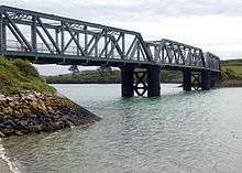
Once past Wadebridge the character changes as the line hugs the tidal River Camel until crossing Little Petherick Creek over a three-span iron bridge and rounding Dennis Hill, it reaches Padstow station which was located on a narrow strip of reclaimed land with the Atlantic Ocean, visible in the distance.[10]
Stations
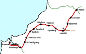
Halwill and Beaworthy; LSWR station on the Holsworthy line; renamed Halwill Junction March 1887
Ashwater;see Ashwater railway station
Tower Hill; The line arrived at Tower Hill (50°41′27″N 4°18′37″W / 50.6908°N 4.3103°W), the station name being taken from a nearby farm. Local people had favoured a station at Boldford, 1½ miles nearer to Launceston,[14] whereas St. Giles on the Heath, ½ mile to the west, was the only village in the area chosen, having a population of 258 in 1901.
The original station layout was identical to Ashwater, but after the First World War the crossing facilities were removed. From 15 June 1920 the Down loop was taken out of use and the signal box closed. The Second World War was to bring a reversal of fortunes when in 1943 the loop was restored and extended by a further 150 yards to enable the servicing of U.S. ammunition dumps in the surrounding countryside. At the same time the signal box was moved from the Down platform to a position in front of the booking office on the Up platform.
The station was oil lit throughout its existence, services being withdrawn in February 1964. The signal box closed on 7 November 1965, from which date the 12 1⁄2 miles (20.1 km) from Halwill to Launceston was a single section. The station closed on 3 October 1966. Today there is almost no trace of the station at Tower Hill. A row of LSWR cottages survives close to the site.
Launceston
; the first station on the line in Cornwall, adjacent to the GWR station.
Egloskerry; Egloskerry station (50°39′07″N 4°27′03″W / 50.6519°N 4.4507°W) opened on 3 October 1892, and had a simple layout with only four points. There was a passing loop, and the station building and signal box were both located on the up platform, with a siding behind serving cattle pens. There was a level crossing at the down end of the station immediately at the platforms' end, the only one between Launceston and Wadebridge.[11] The population of the surrounding area dropped between the building of the railway in the early 1890s and closure in the 1960s; it was always sparse and revenue poor resulting in various economies over the years. In the late 1920s responsibility for the station was passed to the Stationmaster at Otterham, and in 1930 the block instruments were moved from the signalbox to the Booking Office under the charge of a porter-signalman. The goods facilities closed on 9 May 1961 and the goods sidings were removed the following year. The station closed on 3 October 1966. The former station building is now a private dwelling.
Tresmeer; Tresmeer station (50°40′12″N 4°31′02″W / 50.6699°N 4.5171°W) was located in a nearby hamlet, Splatt,[14] and was the closest station to Crackington Haven; this kept passenger numbers up until a bus from Launceston started running in 1935. The station was due to open on 1 July 1892 but a landslip in an adjacent cutting delayed this until 28 July.[14] As at all stations on the line there was a passing loop here, with the station building on the down platform and signal box on the up platform. A single siding behind the down platform gave access to a goods shed and loading dock; goods facilities officially ceased in September 1964 although the line to the loading dock had been removed three months earlier. The siding and passing loop were officially taken out of use on 14 November 1964, with the station becoming unstaffed on 6 January 1965. The station closed on 3 October 1966. The Station is now a private dwelling.
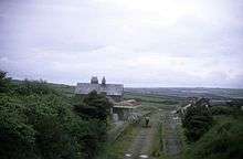
Otterham; Otterham station (50°40′29″N 4°36′47″W / 50.6748°N 4.6130°W) opened on 14 August 1893[15] was situated in sparsely populated country at the junction of the A39 and the B3262. At 850 ft (260 m) above sea level it occupied the most exposed section of the line, open to the fury of Atlantic gales in winter and subject to sea mists in summer. A footpath linked the station with the village, which was more than a mile away: by road the distance was 2 miles (3.2 km). Otterham Station was also the name of a hamlet which grew up near the station.
The down platform was provided with a waiting shelter while the station building and signal box were on the up platform; all three were built of local stone. A single siding on the up side provided access to a loading dock, but there was no goods shed. A second siding parallel to the first was added later. In 1928 Otterham returned the lowest ticket sales on the line. Following the withdrawal of goods facilities on the line on 7 September 1964, the passing loop, sidings, and signal box were officially taken out of use on 7 February 1965, and the trackwork was removed that October. The station was unmanned from 6 December 1965 and closed on 3 October 1966. For many years after closure the station operated as a caravan site. More recently a new road of houses has occupied the trackbed at the eastern end of the old platforms.
Camelford;
Camelford station (50°38′20″N 4°41′14″W / 50.6389°N 4.6871°W) was situated more than 2 miles (3.2 km) from the town "at a road junction in wild country almost devoid of trees".[16] The station had a passing loop with the station building and signal box on the up platform. Like the waiting shelter on the down platform, the buildings were constructed from local stone. As elsewhere on the line, no footbridge was provided. Cattle pens were provided on the single siding, with the goods shed on a loop between the siding and headshunt.
The station opened on 14 August 1893, with station signs proclaiming "Camelford for Boscastle and Tintagel". Camelford was the busiest intermediate station between Launceston and Wadebridge, but the distance from the town kept the passenger numbers low: in 1928 there was an average of just over 20 tickets issued daily, with 35 collected, and this number steadily declining with improved road transport. No alterations were made to the station layout throughout its life; the sidings were officially taken out of use on 30 November 1965 after the end of goods traffic the previous year, but the signal box and passing loop remained operational until closure on 3 October 1966.
The small settlement of Camelford Station grew up around the railway and the station site was for a time occupied by the British Cycling Museum (subsequently closed). More information about the area can be found in the article on Slaughterbridge.
Delabole; The adjacent Delabole Slate quarry, Delabole station (50°37′21″N 4°43′36″W / 50.6226°N 4.7268°W) resulted in considerable outwards mineral traffic. The station opened on 18 October 1893 with a passing loop and two platforms. A single siding was provided behind the up platform, which was where the signal box was sited. On the down side the platform had the station building and a short loading dock with the goods shed on a further siding running behind the platform. A single road through engine shed was provided, with a turntable beyond between the goods shed and a line extending to the quarry. There was a considerable narrow gauge tramway network within the quarry, in existence before the construction of the North Cornwall line. There had earlier been a three-foot gauge network with a four track incline, but by 1879 this had been converted to a 2-feet gauge system with a six-track incline.[17]
As it was situated in the village itself, the station was better used than many on the route, and the proximity of the quarry ensured that freight receipts remained healthy. Goods services were withdrawn on 7 September 1964 and the loading dock was removed; the siding on the down side had been removed some time previously.The station closed on 3 October 1966. The station building is now in use as a private residence, and houses have been built on the site of the up platform.
Port Isaac Road; the station (50°34′35″N 4°46′13″W / 50.5764°N 4.7703°W) was three miles (5 km) from Port Isaac itself, and opened on 1 June 1895, and had a passing loop and a single siding with headshunt that served a goods shed and loading dock. All buildings were of local stone; the station building and signal box locking room were on the up platform, the small waiting shelter on the down platform, and the goods shed. Ticket sales were low, with nearly 4500 annually in 1928, this dropping to under 2000 in 1936; freight dropped in a similar way over the same period. The station layout never changed; the station siding was taken out of use in December 1965. The station was unmanned from 6 December 1965 and closed on 3 October 1966. The station buildings are the best preserved example on the line.
St Kew Highway;
The station here (50°32′36″N 4°46′51″W / 50.5434°N 4.7807°W) opened on 1 June 1895, and had a passing loop and a single siding with headshunt that served a goods shed and loading dock. Both lines through the station had platforms although the down platform had no buildings and was only accessible via a foot crossing at the down end of the station. The station building itself, like the goods shed, was substantially constructed out of local stone, as was the locking room of the signal box. The passing loop was extended in 1939, but the up loop, sidings and signal box were taken out of use on 21 November 1965 as goods services had ceased on 7 September the previous year. Traffic was never very heavy and by the late 1930s was averaging 5 passengers per day, less than a third of that ten years earlier. The station was unmanned from 6 December 1965 and closed on 3 October 1966, although the building functioned for some time as a guest house but is now a private residence.
Wadebridge Junction, about a mile east of Wadebridge station, was the point of convergence of the Bodmin lines with the North Cornwall line; from 3 February 1907 a second independent track was provided, the two lines running parallel; the junction signal box was abolished.[9]
Wadebridge;
Wadebridge Station buildings are currently in use as "The John Betjeman Centre".
Padstow;
Steam railway
A section of trackbed from Launceston is now in use as the Launceston Steam Railway, and the section from Wadebridge to Padstow is now part of the Camel Trail.
Poetical reference
The North Cornwall Railway is commemorated in Sir John Betjeman's classic verse autobiography Summoned by Bells. Betjeman travelled from London to his childhood holiday home in Trebetherick:
"The emptying train, wind in the ventilators,
Soft air, soft Cornish Rains, and silence after steam...."
Puffs out of Egloskerry to Tresmeer
Through minty meadows, under bearded trees,
And hills upon whose sides, the clinging farms hold bible Christians
Can it really be that this same carriage came from Waterloo?
On Wadebridge's platform what a breath of sea scented the Camel valley!
See also
Notes
- ↑ Wilson says 21 July 1892.
References
| Wikimedia Commons has media related to North Cornwall Railway. |
- ↑ Semmens, Peter (1988). The Withered Arm: the Southern West of Exeter. Weybridge: Ian Allen. ISBN 0 7110 1806 5.
- ↑ Roche, T.W.E. (1977). The Withered Arm: Reminiscences of the Southern Lines West of Exeter (new ed.). Bracknell: Forge Books.
- ↑ Awdry, Christopher (1990). Encyclopaedia of British Railway Companies. Wellingborough: Patrick Stephens Limited. ISBN 1 85260 049 7.
- 1 2 3 4 5 6 7 Wilson, B.G. (September–October 1949). "The North Cornwall Line of the Southern Region" (PDF). The Railway Magazine. 95 (583): 326–329. Retrieved 29 October 2008.
- ↑ Carter, E.F. (1959). An Historical Geography of the Railways of the British Isles. London: Cassell.
- ↑ Williams, R.A. (1973). The London & South Western Railway. Vol 2. Newton Abbot: David & Charles. ISBN 0 7153 5940 1.
- 1 2 St John Thomas, David (editor) (1966). Regional History of the Railways of Great Britain; Volume 1: the West Country (3rd ed.). Newton Abbot: David & Charles.
- ↑ Williams, page 279
- 1 2 3 4 Faulkner, J.N.; Williams, R A (1998). The LSWR in the Twentieth Century. Newton Abbot: David & Charles. ISBN 0 7153 8927 0.
- 1 2 3 Vaughan, John (2002). Branches and Byways of Cornwall. Hersham: Oxford Publishing Company. ISBN 0 86093 566 3.
- 1 2 Wroe, David. (1995). An Illustrated History of the North Cornwall Railway. Caernarfon: Irwell Press. ISBN 1 871608 63 5.
- ↑ Bradshaw's Railway Guide for July 1938 (1968 reprint ed.). Newton Abbot: David and Charles.
- ↑ British Railways Western Region. Working Time Table, Section P, Winter 1964/65.
- 1 2 3 Reade, Lewis (1984). Branch Line Memories Volume 3 Southern. St Day: Atlantic. ISBN 0 906899 10 9.
- ↑ Southern Region Record by R.H.Clark
- ↑ Mitchell, Vic; Smith, Keith (1995). Branch Line to Padstow. Middleton Press. ISBN 1 873793 54 5.
- ↑ Bodman, Martin (2012). Inclined Planes in the South West. Truro: Twelveheads Press. ISBN 978 0 906294 75 8.
Further reading
- Cooke, R A (1979). Track Layout Diagrams of the GWR and BR WR, Section 13: North Cornwall. Harwell: R A Cooke.
- Fairclough, Tony (1970). The Story of Cornwall's Railways. Truro: Tor Mark Press.
- Reade, L (1984). The Branch Lines of Cornwall. Redruth: Atlantic Transport And Historical Publishers. ISBN 0 906899 13 3.
External links
Cornwall Portal | |
| Unitary authorities | |
| Major settlements |
|
| Rivers | |
| Topics | |