St John's, Woking
| St John's | |
| St John's and Hook Heath | |
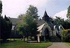 St John's Church, St John's |
|
.jpg) Thick woodland is mixed with open meadow at St John's Lye, between St John's and Hook Heath |
|
 St John's |
|
| Area | 3.46 km2 (1.34 sq mi) |
|---|---|
| Population | 4,656 (2011 Census. Ward)[1] |
| – density | 1,346/km2 (3,490/sq mi) |
| OS grid reference | SU9855 |
| District | Woking |
| Shire county | Surrey |
| Region | South East |
| Country | England |
| Sovereign state | United Kingdom |
| Post town | Woking |
| Postcode district | GU21 |
| Dialling code | 01483 |
| Police | Surrey |
| Fire | Surrey |
| Ambulance | South East Coast |
| EU Parliament | South East England |
| UK Parliament | Woking |
Coordinates: 51°18′40″N 0°35′38″W / 51.311°N 0.594°W
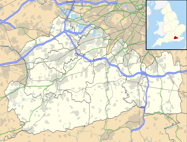
St John's and Hook Heath is a suburban ward in Surrey consisting of two settlements founded in the 19th century in the medieval parish of Woking. The two 'villages' have residents' associations and are centred 2.5 km WSW and SW of Woking's town centre in the north-west of the English county – by including such suburbs, Woking is the largest town in the county. The ward in 2011 contained 1,888 homes across its 3.46 square kilometres (1.34 sq mi).
St John's
History
The village is elongated along the south of the Basingstoke Canal (completed in 1794), providing boat navigation and a quieter alternative for pedestrians and cyclists to access to the town centre than its various suburban streets. St John's formed towards the end of Goldsworth Road leading from what was becoming gradually a town centre. It dates largely from the 19th century, when housing first began to be constructed to accommodate workers employed at the local brickworks.
The village gained its name from the Church of England St John the Baptist's church, built here in 1842 from designs prepared by Sir George Gilbert Scott.[2] The church houses a notable organ, described in the National Pipe Organ Register.[3]
A narrow majority of shops and homes exhibit late Victorian to Edwardian architecture, styles which have been promoted in new buildings in and around its conservation area.[4]
Amenities
- Economic amenities
Today the village is home to a mixture of shops and businesses which include a pharmacy, a small supermarket, restaurants, and office premises.
- Informal social and leisure amenities.
Wildlife is present on the canal and at St John's Lye – a public open space with a football ground, areas set aside for habitat, a rolling elevated landscape, and other outdoor leisure use.
- Organised social and leisure groups
The sole church, mentioned in history, is an active religious group and the dedication of the building gives rise to the name of the settlement.
Scout, guides, a residents' association providing voluntary work, the Women's Institute, a floral art group and the 'Churchill Tennis Club' operate in St John's.[5]
Baroness Anelay of St Johns is a notable member of the Village Hall facilities provision group for St John's Memorial Hall which is in the centre of the village.[6]
- Schools
- A county secondary school is 500m west of St John's western border, The Winston Churchill School
The following primary schools are in St John's:
- Hermitage School
- Oaktree School
- St Hugh of Lincoln Catholic Primary School
- St John's Primary School
Hook Heath
.jpg)
History
The oldest building is The Old Cottage, a 16th century cottage with much of its original core intact. In the ward as a whole no other buildings from the two centuries after this exist.[7] No church is in the suburb of Hook Heath. Clay in the east rises into heath of the Bagshot Formation; a town-side residential hill (other than Fisher's Hill by the south of Woking Golf Club) is named Wych Hill and has a number of streets named after it as well as all the commerce apart from the golf club.[8] Hook Heath adjoins the large St John's Lye open space, the South Western Main Line being the borderline and one road and a footpath connects the two villages. Hook Heath has two roads connecting it to the almost equally elevated district of Woking known as Mount Hermon, passing over and under the Portsmouth Direct Line. The line branches off southwards from the other main line next to some homes of Wych Hill set above the junction in a cutting.
Two large Edwardian homes in tall, ornate architecture in the most rural part of the village are:
- Fisher's Hill House (completed 1901) (by Lutyens) (for Rt Hon Gerald Balfour).[9][10]
- Gorse Hill (completed 1910) (by E. P. Warren)[11]
These are styles which have been imitated across the settlement which slopes up to Fisher's Hill – a conservation area which is a part-developed, part-golf course sub-locality of the neighbourhood. In 1911 also living in the rural hamlet were Alfred Lyttelton (Lib. U.), Secretary of State for the Colonies (1903–1905) and the Duke of Sutherland.[10][12]
Amenities
- Economic amenities
The village has in common with St John's one half of the local Renault dealership and car servicing centre,[13] a large inn (the Star) which closed in 2014 pending redevelopment into a small supermarket, a national chain of hairdressers and a small number of private care homes.
- Social and leisure amenities.
Woking Golf Club with woodland, heath and 18 holes of golf, occupies much of the west of Hook Heath and has large lakeside pavilion golf club restaurant. The clubhouse venue has bar and shop facilities.[14]
Gorse Hill is today an air-conditioned Edwardian mansion, at the end of Mile Path, by the Golf Course, a partial residential road, partial driveway, offering residential management training and meeting and conference facilities here run by the De Vere Venues group.[15]
Hook Heath has a residents' association providing seasonal voluntary work in and with the community.[5]
Demography
At the last census in 2011, the proportion of households in St John's and Hook Heath who owned their home outright was 8.2% above the borough average. The proportion who owned their home with a loan was 0.5% greater than borough average. The borough figures were in turn slightly greater than the national average. The figures showed overall a lower proportion than average of rented residential property and of social housing in St Johns and Hook Heath than either of the two averages however close to the average in Surrey.[1]
| Output area | Population | Households | % Owned outright | % Owned with a loan | hectares[1] |
|---|---|---|---|---|---|
| St Johns and Hook Heath (ward) | 3,192 | 1,888 | 39.8 | 39.4[1] | 346[1] |
Local government
At Surrey County Council, one of the 81 representatives represents the area within the Woking West division.[16]
At Woking Borough Council most wards of the borough are small and deemed appropriate to be represented under the current constitution of councillors by one or two councillors, as is the case for St John's and Hook Heath.[17]
| Election | Member[18] | Electoral Division | |
|---|---|---|---|
| 2011[19] | Linda Kemeny | Woking South West | |
| Election | Member | Ward[17] | |
|---|---|---|---|
| 2010 | John Kingsbury | St John's and Hook Heath | |
| 2011 | Graham Cundy | St John's and Hook Heath | |
Neighbouring areas
Neighbouring suburbs or villages of both villages are Goldsworth Park and Mount Hermon. Two neighbours to the north of the canal are outlying Horsell and Knaphill, which adjoin the canal's towpath and have marginally more retail and commerce. A neighbour to Hook Heath is Mayford from which it is separated by a buffer of garden nurseries and agricultural fields. The borough council groups voluntary and leisure organisations into a Mount Hermon, St. Johns, Hook Heath, Mayford and Sutton Green neighbourhood' of Woking.[5][20]
References
- 1 2 3 4 5 Key Statistics; Quick Statistics: Population Density United Kingdom Census 2011 Office for National Statistics Retrieved 20 November 2013
- ↑ St John's Woking Retrieved 20 November 2013
- ↑ Organ Survey: National Pipe Organ Register Retrieved 20 November 2013
- ↑ St John's Conservation Area Woking Borough Council. Retrieved 20 November 2013
- 1 2 3 Mount Hermon, St. Johns, Hook Heath, Mayford and Sutton Green Neighbourhood Woking Borough Council
- ↑ Window on Woking linked to as charity-run main communities noticeboard Woking Borough Council
- ↑ Historic England. "Details from listed building database (1236960)". National Heritage List for England. The Old Cottage – Grade II
- ↑ Grid square map Ordnance survey website
- ↑ Historic England. "Details from listed building database (1044697)". National Heritage List for England. Fisher's Hill House – Grade II
- 1 2 H.E. Malden (editor) (1911). "Parishes: Woking". A History of the County of Surrey: Volume 3. Institute of Historical Research. Retrieved 20 November 2013.
- ↑ Historic England. "Details from listed building database (1378266)". National Heritage List for England. Gorse Hill, Hook Hill, a listed building at Grade II
- ↑ Fisher's Hill Conservation Area Woking Borough Council. Retrieved 20 November 2013
- ↑ SMC Renault (car dealership and MOT centre) Retrieved 20 November 2013
- ↑ Woking Golf Club Retrieved 20 November 2013
- ↑ De Vere Venues Retrieved 20 November 2013
- ↑ Electoral Divisions Surrey County Council. Retrieved 6 November 2013
- 1 2 Your local councillors Woking Borough Council. Retrieved 6 November 2013
- ↑ Your Councillor Surrey County Council. Retrieved 6 November 2013
- ↑ Four-yearly election results, 2011 Woking Borough Council. Retrieved 6 November 2013
- ↑ Your local services Woking Borough Council