St James railway station, Sydney
St James | ||||||||||||||||
|---|---|---|---|---|---|---|---|---|---|---|---|---|---|---|---|---|
 Elizabeth Street entrance in June 2011 | ||||||||||||||||
| Location | Elizabeth Street, Sydney | |||||||||||||||
| Coordinates | 33°52′13″S 151°12′43″E / 33.8702°S 151.2120°E | |||||||||||||||
| Owned by | RailCorp | |||||||||||||||
| Operated by | Sydney Trains | |||||||||||||||
| Line(s) | City Circle | |||||||||||||||
| Distance | 4.40 kilometres from Central | |||||||||||||||
| Platforms | 2 (1 island) | |||||||||||||||
| Tracks | 2 | |||||||||||||||
| Connections | Bus | |||||||||||||||
| Construction | ||||||||||||||||
| Structure type | Underground | |||||||||||||||
| Disabled access | Yes | |||||||||||||||
| Other information | ||||||||||||||||
| Status | Staffed | |||||||||||||||
| Station code | STJ | |||||||||||||||
| Website | Sydney Trains | |||||||||||||||
| History | ||||||||||||||||
| Opened | 20 December 1926 | |||||||||||||||
| Electrified | Yes | |||||||||||||||
| Services | ||||||||||||||||
| ||||||||||||||||
St James railway station is located on the City Circle, at the northern end of Hyde Park in the Sydney central business district. It is served by Sydney Trains T2 Airport, Inner West & South and T3 Bankstown line services. It is named after the nearby St James' Church.
History


Part of the Bradfield Plan, St James station was originally intended to be a major interchange with the Eastern Suburbs line[1] on Sydney's underground rail system. Plans for the construction of St James included railway lines in four directions, but the original plan was never completed due to disagreements over the routes.[1] Four platforms were completed, but the two inner platforms, intended to support Bradfield's proposed eastern and western suburbs lines, were never put into service.[2] When the Eastern Suburbs line was eventually built it was done so via a different route via Town Hall.
In the 1990s, the two island platforms were connected by filling in the track space between the two inner platforms, resulting in the single, large island platform seen today.
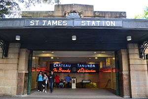
The station itself was designed by New South Wales Government Architect George McRae, but not completed until after his death. An example of Inter-War Stripped Classical architecture[3] influenced by Art Deco. One distinctive feature of the station is a neon sign from the late 1930s advertising Chateau Tanunda Brandy installed by Tucker, Lingard & Co, located at the northern entrance on Elizabeth Street.[4]
St James station opened on 20 December 1926 with the opening of the eastern city line from Central.[5][6] For the first 30 years, St James station was used as a terminating station for the Bankstown, East Hills and Illawarra lines.[3] As a terminating station, St James was equipped with a small signal box and two dead end sidings, located in the tunnel stub at the north end of the station.[2][7] The St James signal box, equipped with pistol grips, was the smallest such box in New South Wales. Trains arriving at St James would disembark passengers on one of the outer platforms, then the train would move to a siding and reverse direction, coming out at the opposite outer platform. During non-peak hours the driver would simply move to the other end of the train while the train was on the siding. During peak hours the train would take on a second driver in the last car while at the platform, then proceed to one of the sidings, where the drivers would exchange control of the train.[7]
Completion of the City Circle loop did not occur until 30 years after St James station opened. Construction of the western city line as far as Wynyard was completed in 1932, but completion of the line connecting Wynyard and St James via Circular Quay, begun in 1936, proved problematic. Construction was halted during World War II, and after 1945, construction was intermittent due to inconsistent funding. By 1953 it was determined that work underground could not proceed at Circular Quay due to water entering the tunnels. A section of rail line above ground was constructed, and the City Circle loop opened on 22 January 1956.
Following the completion of the City Circle, most trains travelled through St James without needing to terminate, and the station's terminating facilities were no longer regularly used. The signal box remained in use until 1990 with the occasional train continuing to terminate at St James to keep the terminating tracks usable for emergencies and railway staff familiar with the procedures.[7] In 1985–86, the signal box was taken out of service for an asbestos abatement project. During this period, train cars allocated for the removal of the asbestos would occupy one or the other of the dead end sidings, which meant that regular use of those lines by passenger trains was not possible. After the asbestos abatement project was completed, the signal box was returned to service until 1990, when asbestos was discovered in the signal box and the sidings. From that time the signal box was not used, and the signals and siding tracks were eventually removed.[7] The sidings were formally closed on 27 July 1991.[8]
In February 2010, a passenger lift between the platform and the concourse opened, followed later by a lift between the concourse and street level.[9]
Underground tunnels
St James station is notable for the abandoned tunnels connected to the station. The Australian Railway Historical Society, with the approval of the State Rail Authority, has given tours of the tunnels, but many people have visited the tunnels by entering along the subway tracks.[1][3] The tunnels were constructed as stubs for the planned eastern and western suburbs lines when the station was built in the 1920s. This was to ensure that the operation of St James would not be disrupted if future work was carried out on the lines.[3] The abandoned tunnels extend some distance in either direction from St James. They proceed for some 250 metres north under Macquarie Street to be roughly parallel with the State Library; to the south they extend to Whitlam Square at the intersection of Liverpool and College Streets.[10]
Use as a mushroom farm
From 1933 to 1934, the tunnel between St James and Circular Quay was used by Raymond Mas as the location for an experimental mushroom farm producing 10,000 pounds (4,500 kg) of mushrooms per month.[7]
Use during World War II
The tunnels originally planned for use as the eastern suburbs line were modified during World War II to serve as a public air raid shelter.[1][7] The abandoned air raid shelter begins in the double track tunnel section at the north end of the station and continues into the two single track tunnels beyond. At the station end the air raid shelter is protected by a blast curtain and the doorways and openings for ventilation between the chambers, each about 30 metres long, are protected by blast curtains.[7][4]
The tunnels were also used during World War II as an operations bunker by the No. 1 Fighter Sector RAAF.[11] The bunker was located in what was intended to be the City Inner Tunnel, access to which was provided by a wooden staircase in a shaft leading upward to Shakespeare Place.[7] Women's Auxiliary Australian Air Force (WAAAF) personnel housed in this operations bunker collected information from radar and weather stations, as well as reports on air traffic, ship and troop movements collected from airports, army and Volunteer Air Observer Corps reporting posts.[11] This section of tunnel was constructed using a cut and cover technique outside St James station, and connects to the tunnels in St James through pilot tunnels, accessible via ladder.[7]
As air quality in the tunnel was poor, WAAAF shifts were limited to six hours. Eventually the health of the WAAAF personnel declined due to poor air quality or poor food, so operations were relocated first to The Capital Theatre in Bankstown, and subsequently to the Bankstown Bunker on Black Charlies Hill near Condell Park.[11]
The staircase used to access the bunker was destroyed by fire on 16 November 1968. Smoke from this fire interrupted train service for approximately twelve hours.[7]
In popular culture
The tunnels which had been prepared as an air raid shelter were also used by the Australian Broadcasting Corporation (ABC) as a location for one episode of the TV series Police Rescue in the early 1990s. In the episode, a boy who had fallen down a storm drain is rescued.[3]
There is also a large bell in one of the tunnels. According to one source, the ABC used this bell to simulate the sound of Big Ben for use in a TV series during the 1960s,[3] but that information has not been verified. Another source suggests that the bell was installed by Nigel Helyer in 1992 as a work of art.[1] The piece, titled "An UnRequited Place", was part of the Working in Public project created by ArtSpace Sydney, and was a combination of the physical sculpture, performance and audio broadcast.[12] For 21 days the sound of the bell tolling at midnight was broadcast by the ABC.[1][12]
The platforms were used as a shooting location in 2003 film The Matrix Revolutions.[13][14][15]
In 2008, the station was used as a location for the mini-series False Witness.[16] The platforms featured in Zoë Badwi's 2010 music video Freefallin. In 2011, The Tunnel was filmed in the abandoned tunnels.[17][18]
Underground lake
One of the abandoned tunnels flooded and produced an underground lake, ten metres wide, five metres deep, and one kilometre long.[19] Known as St James Lake, it has been used for many years as a swimming hole.[3] In recent years, due to drought and diminishing water supplies in underground aquifers, there have been a number of proposals for how to use the abandoned tunnels and other underground spaces for storage and recycling of water.
In the mid-2000s, Ian Kiernan proposed that an abandoned water tunnel, Busby's Bore, be redirected to St James Lake where water could be stored and recycled. Busby's Bore was originally used to carry water from nearby swamps to the Hyde Park area, but was abandoned for that purpose in the 1890s after becoming contaminated by sewage. In 2004 the idea of recycling the water from the bore received support from the executive director of the Botanical Gardens Trust, Tim Entwisle.[20]
During 2006, it was proposed that the northern unused tunnels be used as a reservoir for irrigation water for The Domain and the Royal Botanic Gardens as part of a Clean Up Australia project to create a series of water reclamation and storage facilities.[21] Clean Up Australia partnered with a number of groups in the attempt to move the project forward, and in 2007 obtained funding to proceed.[22] Also in 2007, State Premier Morris Iemma announced plans to harvest rainwater at Parliament House. According to this plan all storm water from Parliament House, the State Library and Sydney Hospital (all on Macquarie Street) would be drained into the tunnels, treated, and then pumped back to storage tanks at the surface for use in non-potable water systems, saving an estimated 17 million litres each year.[19]
In interview from January 2008 Minister for Transport John Watkins said he intended to ask RailCorp to begin a study to determine if the underground network of tunnels could be used for water storage.[23] The project began on 15 January 2008 when water tanks for storage of the recycled water were installed on the top of Parliament House.[24] [25]
Platforms & services
| Platform | Line | Stopping pattern | Notes |
| 1 | services to Homebush, Leppington & Campbelltown | [26] | |
|---|---|---|---|
| 2 | services to Kingsgrove, Revesby, Campbelltown & Macarthur | [27] | |
| services to Lidcombe & Liverpool via Bankstown | [28] |
Transport links
Elizabeth Street
|
|
Trackplan

References
- 1 2 3 4 5 6 St James tunnels Steve Dow
- 1 2 St James Station NSWRail.net
- 1 2 3 4 5 6 7 St James railway station Sydney Architecture
- 1 2 St James Railway Station NSW Environment & Heritage
- ↑ Sydney Morning Herald 21 December 1926 p11 and p12
- ↑ "60 Years Ago" Railway Digest December 1986 page 398
- 1 2 3 4 5 6 7 8 9 10 St James Tunnels Neety
- ↑ "Signalling & Safeworking" Railway Digest November 1991 page 416
- ↑ "Transit Newsfile: Sydney Trains" Transit Australia volume 65 number 11 November 2010
- ↑ The St James Railway Tunnels Australian Railway Historical Society
- 1 2 3 No. 1 Fighter Sector Headquarters RAAF, later known as No. 101 Fighter Control Unit RAAF Oz at War
- 1 2 An UnRequited Place Sonic Objects
- ↑ Sydney Movie Set Locations
- ↑ Staircase (the Matrix) World Reviewer
- ↑ Filming locations for The Matrix Revolutions Internet Movie Database
- ↑ Filming locations for False Witness Internet Movie Database
- ↑ About The Tunnel Movie
- ↑ Filming locations for The Tunnel Internet Movie Database
- 1 2 Underground lake gives hope Daily Telegraph 5 February 2007
- ↑ New interest in dld Sydney bore Waste Management & Environment 7 October 2004
- ↑ Solution to water crisis is history Sydney Morning Herald 1 June 2006
- ↑ Busby's bore Clean Up Australia
- ↑ Secret city reservoir for drought Daily Telegraph 16 January 2008
- ↑ Sydney harnesses CBD's underground lake ABC News 15 January 2008
- ↑ Water scheme scratches surface Sydney Morning Herald 16 January 2008
- ↑ "T2: Inner West & South line timetable" (PDF). Sydney Trains. 13 December 2015.
- ↑ "T2: Airport line timetable" (PDF). Sydney Trains. 20 October 2013 [amended January 2015].
- ↑ "T3: Bankstown line timetable" (PDF). Sydney Trains. 20 October 2013 [amended January 2015].
External links
 Media related to St James railway station at Wikimedia Commons
- St James station details Sydney Trains
- |Sydney's abandoned underground rail tunnels, on ABC Radio National
- Sydney Architecture Images
- Lake St James - pictures of the lake that has formed in the northern unused tunnel.
- St James air raid shelter - Photo of one of the five remaining bomb shelters.
- PDF of routes served by St. James Station
- Sydney Downunder news report
- HET Past Tours