St James's
| St James's | |
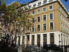 BP head office in St James's Square |
|
 St James's |
|
| Population | 10,828 (2011 Census. Ward)[1] |
|---|---|
| OS grid reference | TQ295805 |
| – Charing Cross | 0.5 mi (0.8 km) E |
| London borough | Westminster |
| Ceremonial county | Greater London |
| Region | London |
| Country | England |
| Sovereign state | United Kingdom |
| Post town | LONDON |
| Postcode district | SW1 |
| Dialling code | 020 |
| Police | Metropolitan |
| Fire | London |
| Ambulance | London |
| EU Parliament | London |
| UK Parliament | Cities of London and Westminster |
| London Assembly | West Central |
Coordinates: 51°30′31″N 0°07′59″W / 51.5085°N 0.1330°W
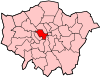
St James's is a central district in the City of Westminster, London, forming part of the West End. In the 17th century the area developed as a residential location for the British aristocracy and around the 19th century was the focus of the development of gentlemen's clubs. Anciently part of the parish of St Martin in the Fields, much of it formed the parish of St James from 1685 to 1922. Since the Second World War the area has transitioned from residential to commercial use.
History
Toponymy
The St James name is derived from the dedication of a 12th-century leper hospital to Saint James the Less. The hospital site is now occupied by St James's Palace.[2] The area became known as "Clubland" because of the historic presence of gentlemen's clubs.[3]
Urban development
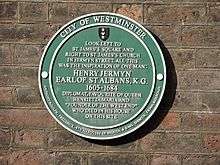
St James's was once part of the same royal park as Green Park and St. James's Park. In the 1660s, Charles II gave the right to develop the area to Henry Jermyn, 1st Earl of St Albans, who developed it as a predominantly aristocratic residential area around a grid of streets centred on St James's Square. Until the Second World War, St James's remained one of the most exclusive residential enclaves in London. Notable residences include St James's Palace, Clarence House, Marlborough House, Lancaster House, Spencer House, Schomberg House, Norfolk House and Bridgewater House.
Local government
St James's was in the ancient parish of St Martin in the Fields in the Liberty of Westminster. Attempts made in 1664, 1668 and 1670 to separate St James's from the parish were resisted by St Martin's vestry.[4] The building of St James's Church, Piccadilly in 1684 forced the issue, and a new parish of St James within the Liberty of Westminster was created in 1685. The parish stretched from Oxford Street in the north to Pall Mall in the south.[5] It roughly corresponded to the contemporary St James's area, but extended into parts of Soho and Mayfair. Land south of Pall Mall remained in St Martin in the Fields' parish and St James's Park was split between the parishes of St Martin and St Margaret. St James's Palace was an extra-parochial area and not part of any parish. A select vestry was created for the new parish.
Governance
For elections to Westminster City Council, the area is part of the St James's ward.[6] The ward includes Covent Garden, Strand, Westminster and part of Mayfair. The ward elects three councillors.[7]
Geography
St James's is bounded to the north by Piccadilly, to the west by Green Park, to the south by The Mall and St. James's Park and to the east by Haymarket.
Notable streets include:
- St James's Square, which retains many of its original houses but is mostly in office use. The London Library is located there.
- Jermyn Street, an upmarket retail street best known for bespoke shirtmakers and shops offering the finest gentlemen's attire.
- Pall Mall, which contains many of London's gentlemen's clubs.
- Haymarket was once the best known centre of prostitution in London, but no trace remains. It contains two historic theatres: the Haymarket Theatre and Her Majesty's Theatre.
- Carlton House Terrace, a pair of grand terraces of houses designed by John Nash overlooking St. James's Park.
- St James's Street which runs down from Piccadilly to St James's Palace.
Economy
St James's is a predominantly commercial area with some of the highest rents in London and, consequently, the world. The auction house Christie's is based in King Street, and the surrounding streets contain many upmarket art and antique dealers including Colnaghi, Agnew’s Gallery, Hazlitt, Gooden & Fox, Johnny Van Haeften, Stoppenbach & Delestre Ltd, The Sladmore Gallery and S Franses Ltd.
BP is headquartered in St James's.[8] Office space to rent is the most expensive in the world, costing up to five times the average rents in New York City, Paris and Sydney.[9]
The area is home to fine wine merchants including Berry Brothers and Rudd, at number 3 St James's Street. Adjoining St James's Street is Jermyn Street, famous for tailoring. Some famous cigar retailers are at 35 St James's Street, occupied by Davidoff of London; J.J. Fox at 19 St James's Street and Dunhill at 50 Jermyn St.
Shoemaker, Wildsmith,designers of the first loafer, was located at 41 Duke Street but is now at 13 Savile Row.
Culture


Art galleries catering for a spectrum of tastes occupy premises in the area. The White Cube gallery, which represents Damien Hirst and Tracey Emin, opened in Duke Street before moving to Hoxton Square. In September 2006, it opened a second gallery at 25–26 Mason's Yard, off Duke Street, on a plot previously occupied by an electricity substation. The gallery is the first free-standing building to be built in the area for more than 30 years.
Other notable modern and contemporary art dealers in the St James's area include Helly Nahmad Gallery, Paisnel Gallery, Bernard Jacobson Gallery, Thomas Dane, Whitford Fine Art and Panter & Hall.
On the southernmost border of St James's is The Mall where The Institute of Contemporary Arts and the Mall Galleries are located.
Clubland
St James's is home to many of the best known gentlemen's clubs in London, and sometimes, though not as often as formerly, referred to as "Clubland".[10] The clubs are organisations of English high society. A variety of groups congregate here, such as royals, military officers, motoring enthusiasts, and other groups. In 1990, the Carlton Club, traditional meeting place for members of the Conservative Party, was struck by an IRA bomb.
See also
References
- ↑ "City of Westminster ward population 2011". Neighbourhood Statistics. Office for National Statistics. Retrieved 15 October 2016.
- ↑ Mills, A.D. (2001). Dictionary of London Place Names. Oxford University Press. ISBN 978-0199566785.
- ↑ "Pall Mall; Clubland | British History Online". British-history.ac.uk. 2015-05-23. Retrieved 2015-05-29.
- ↑ "The Parish and Vestry of St. James | British History Online". British-history.ac.uk. 2015-05-24. Retrieved 2015-05-29.
- ↑ "Boundary Map of Westminster St James CP/Vest". Visionofbritain.org.uk. Retrieved 2015-05-29.
- ↑ "St James's Ward Profile : July 2013" (PDF). Westminster.gov.uk. Retrieved 2015-05-29.
- ↑ "Westminster City Council". Westminster.gov.uk. Retrieved 2015-05-29.
- ↑ Archived 25 May 2009 at the Wayback Machine.
- ↑ Campbell, Peter (2013-02-19). "West End has the most expensive office space in the world costing more than double New York's 5th Avenue, Paris and Sydney | Daily Mail Online". Dailymail.co.uk. Retrieved 2015-05-29.
- ↑ "History : Royal Opera Arcade". Royaloperaarcade.com. Retrieved 2015-05-29.
Further reading
- John Timbs (1867), "St. James's", Curiosities of London (2nd ed.), London: J.C. Hotten, OCLC 12878129
External links
- St James's Westminster, Part 1 – a volume of the Survey of London which provides a very detailed architectural history of most of St James's. However a few sections of the parish of St James's fall outside the district, so they are omitted (map).
- Map of St James's and surrounding areas
- Clubland at Virtual London
- Tourist Information on St James's
- Area website for St James's with profiles on shops, restaurants and galleries in the area and a full events calendar