Canal de Saint-Quentin
| Canal de Saint-Quentin | |
|---|---|
|
Lock Noyelles-sur-Escaut on Canal Saint-Quentin | |
| Specifications | |
| Length | 92.5 km (57.5 mi) [1] |
| Lock length | 38.5 m (126 ft) |
| Lock width | 5.05 m (16.6 ft) |
| Minimum boat draft | 2.2 m (7.2 ft) |
| Minimum boat air draft | 3.5 m (11 ft) |
| Locks | 35 [1][2] |
| Status | Open |
| History | |
| Former names | Canal Crozat or Canal de Picardie between Chauny and Saint-Simon in 1738 [1] |
| Principal engineer | Original engineer named Devicq in 1727. Died in 1742. |
| Other engineer(s) | Revised plan by Laurent de Lyonne. Work began in 1768. |
| Date completed | Napoléon oficiated at the opening in 1810.[1] |
| Geography | |
| Start point | Canalised Escaut River(Scheldt) in Cambrai |
| End point | Chauny |
| Beginning coordinates | 50°10′35″N 3°13′18″E / 50.17646°N 3.22173°E |
| Ending coordinates | 49°36′29″N 3°13′31″E / 49.60814°N 3.22526°E |
| Connects to | Canal latéral à l'Oise, Canal de l'Oise à l'Aisne, Canal de la Sambre à l'Oise, Canalised Escaut River [2] |

The Canal de Saint-Quentin is a canal in northern France connecting the canalised Escaut River in Cambrai to the Canal latéral à l'Oise [1] and Canal de l'Oise à l'Aisne in Chauny[2]
History
Canal construction was accomplished in two phases, the second much longer than the first. The kings' ministers Colbert and Mazarin had both proposed linking the River Oise and the Somme in the 17th century and this resulted in the Canal Crozat, or Canal de Picardie, between Chauny and Saint-Simon in 1738. The remainder, connecting the Seine Basin with the Escaut was a lengthy process. The original designer, Devicq in 1727, died in 1742. Little was accomplished until Napoléon demanded that work begin again in 1801. He officiated at the opening in April 1810.[1]
The canal was such a success that traffic levels required the need to build duplicate locks, deepen the channel, enlarge the tunnels, and increase water supplies. Improvements in the 20th century included electric barge traction on rails, installed during World War I, mechanizing locks, and lighting the heavier traveled sections. Later, the locks were operated automatically, using radar.[3] By 1878, up to 110 barges were crossing the summit daily. The Canal du Nord was built as a duplicate path and completed in 1965. The canal carried more freight than any other man-made waterway in France in 1964.[1]
Battle of St Quentin Canal
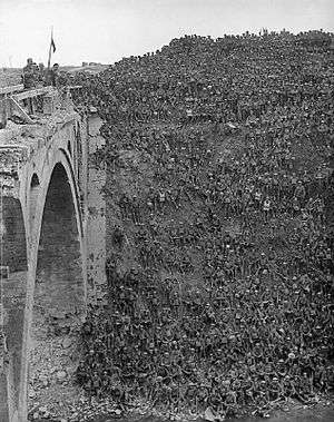
The Canal in World War I formed part of the Hindenburg Line, a German defensive position built during the winter of 1916–1917. The Allied crossing of the St Quentin Canal in 1918 was a significant part of the Hundred Days Offensive that led to the Armistice.
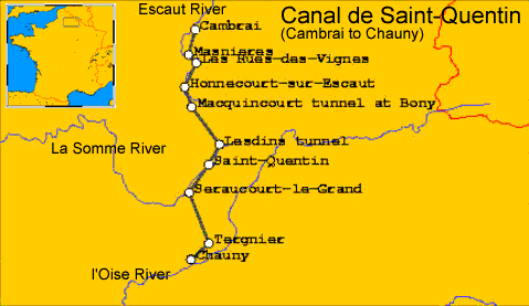
En route
- PK 0 Cambrai
- PK 11 Masnières
- PK 18 Les Rues-des-Vignes
- PK 23 Honnecourt-sur-Escaut
- PK 28.5-35 Riqueval tunnel (5670m) [2] Bony [1]
- PK 42-43 Tronquoy tunnel (1098m) [2] Lesdins [1]
- PK 53 St-Quentin [2]
- PK 62 Seraucourt-le-Grand
- PK 68 Right Petite Somme: St-Simon to Ham. Closed 2006 Left continues [2] Link to Canal de la Somme[1]
- PK 80.5 Voyaux
- PK 83 Tergnier [2]
- PK 85 T-junction left 3.8 km branch Canal de Saint-Quentin to Canal de la Sambre à l'Oise Right continues as Canal de Saint-Quentin.[2]
- PK 92 Chauny, the canal continues as Canal latéral à l'Oise towards Paris. Left Canal de l'Oise à l'Aisne[2]
References
- 1 2 3 4 5 6 7 8 9 10 McKnight, Hugh (2005). Cruising French Waterways, 4th Edition. Sheridan House. pp. 16, 37–42. ISBN 978-1-57409-087-1.
- 1 2 3 4 5 6 7 8 9 10 Jefferson, David (2009). Through the French Canals. Adlard Coles Nautical. pp. 197–199. ISBN 978-1-4081-0381-4.
- ↑ McKnight, Hugh (2005). Cruising French Waterways (4 ed.). London: Bloomsbury. p. 36. ISBN 9780713666380.
External links
| Wikimedia Commons has media related to Canal de Saint-Quentin. |