Sankt Peter, Baden-Württemberg
| St. Peter | ||
|---|---|---|
| ||
 St. Peter | ||
Location of St. Peter within Breisgau-Hochschwarzwald district 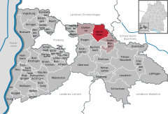
 | ||
| Coordinates: 48°0′59″N 8°1′57″E / 48.01639°N 8.03250°ECoordinates: 48°0′59″N 8°1′57″E / 48.01639°N 8.03250°E | ||
| Country | Germany | |
| State | Baden-Württemberg | |
| Admin. region | Freiburg | |
| District | Breisgau-Hochschwarzwald | |
| Government | ||
| • Mayor | Gottfried Rohrer (CDU) | |
| Area | ||
| • Total | 35.93 km2 (13.87 sq mi) | |
| Population (2015-12-31)[1] | ||
| • Total | 2,583 | |
| • Density | 72/km2 (190/sq mi) | |
| Time zone | CET/CEST (UTC+1/+2) | |
| Postal codes | 79271 | |
| Dialling codes | 07660 | |
| Vehicle registration | FR | |
| Website | www.st-peter-schwarzwald.de | |

Sankt Peter is a municipality in the district of Breisgau-Hochschwarzwald in Baden-Württemberg in Germany.
Gallery
 Sankt Peter, church: die Klosterkirche Sankt Peter und Paul
 Sankt Peter, Kaufstätte Klosterhof
 Sankt Peter, view to a street: die Steyrer Strasse
 between Sankt Peter and Glottertal, road panorama
Data
Location
St. Peter is a climatic spa located within the Southern Black Forest Nature Park, on the southern flank of the Kandel, about 12 miles east of Freiburg im Breisgau.
Administrative structure
To the municipality of St. Peter belong the village Bürgerschaft, the hamlet Sägendobel, the localities Kandelberg, Neuwelt, Oberibental, Ränke, Rohr, Schmittenbach, Schönhöfe, Seelgut and Willmendobel as well as the farms Eckpeterhof, Langeck and Lindlehof.
References
External links
- (German) St. Peter: History and images
- (German) St. Peter
This article is issued from Wikipedia - version of the 6/21/2015. The text is available under the Creative Commons Attribution/Share Alike but additional terms may apply for the media files.