St. Elmo Historic District (Chattanooga, Tennessee)
|
St. Elmo Historic District | |
|
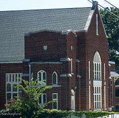
St. Elmo United Methodist Church | |
  | |
| Location | Chattanooga, Tennessee |
|---|---|
| Coordinates | 34°59′43″N 85°16′49″W / 34.99528°N 85.28028°WCoordinates: 34°59′43″N 85°16′49″W / 34.99528°N 85.28028°W |
| Built | 1885 |
| Architect | Various |
| Architectural style | Victorian and Victorian bungalow |
| NRHP Reference # | 82003976 |
| Added to NRHP | April 4, 1992[1] |
The St. Elmo Historic District, or St. Elmo for short, is a neighborhood in the city of Chattanooga, Tennessee. It is situated in the southernmost part of Hamilton County within the valley of Lookout Mountain below the part of the Tennessee River known as Moccasin Bend. St Elmo is at the crossroads of two ancient Indian trails, and was first occupied by Native American hunters and gatherers in the Woodland period, then agricultural Mississippians, including Euchee and Muscogee, and for a brief period between 1776 and 1786, the Cherokees in a community called Lookout Town. St. Elmo became part of the city of Chattanooga when it was annexed in September 1929.
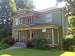
Hundreds of properties in the neighborhood were listed on the National Register in 1982, and in 1996 St. Elmo was designated a Local Historic District. Many of the buildings from the late 19th and early 20th century have been preserved.
Settlement
In 1776, Cherokee chief Dragging Canoe and several hundred Cherokee warriors migrated to Chickamauga Creek after objecting to a treaty between other Cherokees and American land speculators and promising active resistance. They became known as the Chickamaugas, and eventually moved farther down the Tennessee River below The Suck; to the other end of the Tennessee River Gorge. There they built the "Five Lower Towns" at Running Water (now Whiteside) and further downriver. Between 1777 and 1782, the so-called "Chickamaugas" also had a town called Tsatanugi (or Chatanuga, based on the Muscogee word cvto - rock), near here along Chattanooga Creek.
Daniel Ross, a young Scottish immigrant, came to the area in 1785 and worked at a trading post with John McDonald, the area's first businessman. Ross married McDonald's daughter and the two built a house in what was to become St. Elmo after the Wars. Their youngest son, John Ross, was the leader of the Cherokee Nation who would call for passive resistance to the federal Indian removal policies that led to the Trail of Tears in 1838.
Early St. Elmo and Chattanooga
Up until 1838, the Tennessee River was the dividing line between Hamilton County and the Cherokee country. That year, the community of Ross's Landing was surveyed, and in 1839 the village of Chattanooga was established north of the mouth of Chattanooga Creek. In 1840, the state of Tennessee began to sell the property formerly owned by the Cherokees at the rate of $7.50 an acre. Much of the Tennessee side of Lookout Mountain and the surrounding land was purchased by the Whiteside and Cravens families.
The area at the foot of Lookout Mountain was acquired shortly after the Civil War by Colonel Abraham Malone Johnson and his wife, Thankful Whiteside Johnson. In 1885, Colonel Johnson divided his farm into residential and commercial lots. The name "St. Elmo" was taken from the title of a novel written by Augusta J. Evans Wilson, who had spent several summers on Lookout Mountain and found the view similar to that of St. Elmo Castle in Naples, Italy. Her book, St. Elmo, was published in 1866, and ultimately rivaled Harriet Beecher Stowe's Uncle Tom's Cabin in impact and influence. St. Elmo became one of the top three best-selling novels of the nineteenth century.
Yellow Fever and Urban Development
A yellow fever epidemic in Chattanooga caused an exodus in 1878. Almost 12,000 people fled the city, many going to Lookout Mountain. At the time, the mountain was accessible on the north side only by a four-hour trip up the old Whiteside Turnpike, which was built in the 1850s and cost a toll of two dollars. Complaints about the toll led to the 1879 construction of the St. Elmo Turnpike, which had an easier grade and a lower toll (the St. Elmo turnpike was paved and renamed the Adolph S. Ochs Highway in the late 1920s).
Until the 1880s, the area at the foot of Lookout Mountain remained primarily a wooded area. The real boom in the growth of St. Elmo as a residential community coincided with the planning and development of the Chickamauga and Chattanooga National Military Park, which was dedicated in 1890. At the time, St. Elmo saw development resulting from both a general real estate and construction boom in the South and the 1893 expansion of an electric trolley from Chattanooga to St. Elmo.
Connecting St. Elmo to Chattanooga
The trolley was not the only transportation development to influence the history of St. Elmo. In 1887, the narrow-gauge Incline #1 ran cars from St. Elmo up to the bluffs of Lookout Mountain. Soon after, a broad-gauge line was opened for carrying regular railroad cars to the mountaintop. And finally, in 1895, Incline #2 (now known as the Incline Railway) started taking passengers up the steepest part of the mountain. Its views were popular with both residents and tourists, and by 1900 the success of this railway closed down all of its competitors. Today, "America's Most Amazing Mile" still enjoys the distinction of being the world's steepest passenger railway.
In 1905, St. Elmo was incorporated and a town commission was formed for the purpose of securing funding for a school. A bond was issued, and work on the building was completed at the end of 1906. The small brick building replaced St. Elmo's first school, established in 1891.
It wasn't until 1926 that a direct route was established between St. Elmo and Chattanooga. The city wanted to provide a thoroughfare to St. Elmo and Lookout Mountain, but Broad Street ended abruptly at Ninth Street (now Martin Luther King Jr Boulevard), terminating at a railroad station owned by the State of Georgia. Negotiations to open a passageway for a road through the south side had failed over the years. Chattanooga Commissioner Ed Bass took matters into his own hands on the night of May 6, when he and a crew of city workers bulldozed enough of the buildings to establish a right-of-way for cars. The city got its road, and eventually Georgia sold the rest of its holdings in the area.
References
- ↑ "NPS Focus". National Register of Historic Places. National Park Service. Retrieved March 14, 2010.
External links
- St. Elmo Historic District official website
- St. Elmo Flickr Photo Group
- A Visual History St. Elmo Yesterday and Today
- St. Elmo Historic District on LocalWiki