Spring Creek, Brooklyn
| Spring Creek | |
|---|---|
| Neighborhood of Brooklyn | |
|
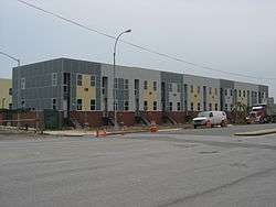
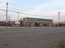
Houses of the Nehemiah Spring Creek development under construction in 2008. | |
 Spring Creek  Spring Creek  Spring Creek Spring Creek | |
| Coordinates: 40°39′31″N 73°52′29″W / 40.65873°N 73.874603°WCoordinates: 40°39′31″N 73°52′29″W / 40.65873°N 73.874603°W | |
| Locale | East New York, Brooklyn, New York |
| ZIP codes | 11207, 11208, 11239 |
Spring Creek, previously called Spring Creek Basin,[1][2] is a neighborhood within the East New York section of Brooklyn in New York City. Part of Brooklyn Community Board 5,[3][4] it roughly comprises the southern portions of East New York between Flatlands Avenue to the north, and Jamaica Bay and the Gateway National Recreation Area to the south, with the Brooklyn neighborhood of Canarsie to the west and the Queens neighborhood of Howard Beach to the east.[3] It is named after Spring Creek, one of several creeks that formerly ran through the area and drained into Jamaica Bay.[5][6]
For most of its history Spring Creek was considered the place where "the city came to an end",[7] consisting of undeveloped marshland used as illegal dumping grounds, and hosting several large landfills and an incinerator during the 20th century.[1][5] Much of the area was designated as the Fresh Creek Urban Renewal Area in 1967. The area has since seen several major development and restoration projects, including the Starrett City apartment complex, the Gateway Center shopping complex, several affordable housing communities, and Spring Creek Park.[5][8][9] Spring Creek had the largest net gain in population in Brooklyn between 1940 and 2010, an increase of 330%.[10]
Location
Spring Creek comprises the southeastern section of East New York, located to the south of New Lots.[3][11] It is bounded to the north by Flatlands Avenue, to the east by Fountain Avenue (at the former drainage basin of Spring Creek and Betts Creek on the Brooklyn-Queens border), and to the west by Schenck Avenue, Gateway Drive and Hendrix Creek. To the south is the Shore Parkway portion of the Belt Parkway, the Gateway National Recreation Area, and Jamaica Bay.[3][5][11][12] Including Starrett City (which is physically separated by Hendrix Creek), the neighborhood extends west to Louisiana Avenue and Fresh Creek at the boundary with Canarsie.[3] Several areas north to Linden Boulevard, between Fountain Avenue to the west and 78th Street to the east, are also considered part of Spring Creek;[13][14] this area was formerly known as Plunders Neck.[11][15][16] Linden Boulevard was previously considered the northern boundary of Spring Creek.[1][17]
To the south of the Belt Parkway are the Pennsylvania Avenue and Fountain Avenue Landfills (PAL/FAL).[18] The two 130-foot high landfills, 110 acres and 297 acres in size respectively, were opened in 1956 and 1961 respectively, man-made peninsulas created from former marshland and open water. The massive Fountain Avenue Landfill served as one of five major city facilities for regular refuse at the time, along with the Fresh Kills and Brookefield Landfills in Staten Island; a facility in Pelham Bay Park in the Bronx; and another one in Edgemere, Queens. The landfills closed around 1985. The two sites have since undergone restoration and are now part of Spring Creek Park.[5][19][20][21][22][23][24]
Most of Spring Creek and Starrett City fall under the 11239 ZIP code, but some portions of Spring Creek north of Flatlands Avenue, as well as the Brooklyn Developmental Center, fall under the 11207, and 11208 ZIP codes.[12]
History
Early settlement
Prior to European colonization, what is now Spring Creek consisted of salt marshes and several creeks, which drained into Jamaica Bay. The namesake creek itself ran north as far as Atlantic Avenue and Eldert Lane, near Highland Park (at the north end of Brooklyn) and Forest Park, forming the border of Brooklyn and Queens. The northern shores of Jamaica Bay were inhabited by the Jameco, Canarsee, and Rockaway Native American groups (for whom the Jamaica, Canarsie, and Rockaway areas would be named).[5][6][11][16][25][26] In the 1650s, Dutch colonists began settling in the eastern sections of Brooklyn, forming the towns of Flatbush and New Lots (the predecessor to East New York).[5][27] The area, along with the rest of Brooklyn and modern New York City, was ceded to the British Empire in 1664.[5]
The first development in the Spring Creek area took place in the 1890s, a 30-acre (12 ha) farm built by the Cozine family, the likely namesake of Cozine Avenue. This farm included a house and stable at the modern-day intersection of Elton Street and Vandalia Avenue.[5] Plunders Neck, then a peninsula between Betts and Spring Creeks, took its name from pirates who occupied the waters and "plundered." In the late 19th century it hosted a small community of wooden houses housing around 50 families who fished and farmed in the area. A hotel was erected along Mill Pond, near the basin of the creeks, at what was called Forbell's Landing.[11][15][16] Otherwise, the area remained uninhabited.[5][11]
Early development
Beginning in the 1920s, the city planned to develop a large ship and rail terminal along Jamaica Bay, particularly along the Paerdegat Basin in nearby Canarsie, to relieve port operations in the greater New York Harbor. The project would have constructed new rail facilities to connect with the Long Island Rail Road, New York Connecting Railroad, and a proposed rail tunnel to Staten Island.[19][28][29][30][31] Around this time, a street grid was mapped in Spring Creek, though most of the streets had yet to be constructed.[19] In 1930, Spring Creek Park and the Shore Parkway portion of the Belt Parkway were proposed by Robert Moses, along with several other parks and highways.[25][26][32] Land for both projects along Jamaica Bay in the area was acquired via condemnation in 1938, and Shore Parkway opened in 1940, with an interchange to the south end of Pennsylvania Avenue.[1][5][7][19][25][26] This put an end to the proposed Jamaica Bay seaport.[33] Later plans by Robert Moses in the 1950s called for Spring Creek Park to extend to Cross Bay Boulevard in Howard Beach, Queens and include a new beach and boat basin.[34]
The Milford Street Landfill began operations in the 1930s, occupying much of the Spring Creek neighborhood.[5] The Milford Street Landfill was closed in 1950.[5] However, the South Shore Incinerator at Forbell Street and Wortman Avenue was dedicated on June 30, 1954,[35][36] and the Pennsylvania and Fountain Avenue Landfills were opened in 1956 and 1961 respectively,[19][23] on land previously earmarked for Spring Creek Park.[1][34] A sewage treatment plant adjacent to Hendrix Creek was also opened around this time.[5][8][11]
In spite of the new highway, Spring Creek Basin, as the area was then called,[1][2] continued to remain undeveloped while other local areas were extensively built up. This was in part due to its remoteness from the city's focal points (such as Manhattan and Downtown Brooklyn), its distance away from the nearest rapid transit lines, the presence of the landfills, incinerator, and water treatment plant in the area, and noise from the nearby Idlewild Airport (now John F. Kennedy International Airport).[1][7][11][19] A 1943 city profile called the area "Brooklyn's least populated district", with many streets remaining as mapped but not constructed.[1] Smoke and odor from the incinerator and landfills, meanwhile, were reported to extend to the Queens neighborhoods of Howard Beach and Ozone Park.[37][38][39] The remoteness of the area led it to be used as an illegal dumping ground for waste. The territory, particularly the landfills, is also said to have been used for dumping corpses, most notably by Murder, Inc. and the Gambino crime family;[7][19][40][41] human remains from modern incidents have been unearthed as recently as 2013.[19][41][42]
Urban renewal and development
In 1967, the area south of Flatlands Avenue between Schenck and Fountain Avenues (on the peninsula between Hendrix and Spring Creeks) was designated as the Fresh Creek Urban Renewal Area (FCURA). During this time, the remaining 19th Century buildings in this vicinity were demolished.[5][8][9] That year, a major development project was proposed, which would include a state mental health facility, several intermediate schools, a high school, a community college, a shopping center, a branch library, an expansion of Spring Creek Park, and several thousand housing units including 8,000 middle-income condominium-style units.[17] In preparation for the development, in 1968 under the city's Program for Action, it was proposed to extend the IRT New Lots Line and the BMT Canarsie Line of the New York City Subway to the Spring Creek area; the New Lots Line would have been extended to Flatlands Avenue near Elton and Linwood Streets.[43] These extensions were cancelled in the mid-1970s, largely due to the city's fiscal crisis at the time.[27][28] Under the 1967 FCURA plan, the mental health facility (called the Brooklyn Developmental Center) was opened in 1973,[5][8] the condominium complex (the Starrett City apartment complex) opened in 1974,[7] and the Spring Creek branch of the Brooklyn Public Library opened in the summer of 1977.[44] The area was officially given the name Spring Creek in 1973 by Brooklyn borough president Sebastian Leone.[11]
Following community protests, and seepage of contaminated oil into Jamaica Bay, the Pennsylvania and Fountain landfills ceased municipal waste operations in 1979 and 1985 respectively, after which they were absorbed into the Gateway National Recreation Area.[18][19][23][45][46][47] On June 25, 1996, the New York City Council amended the original Fresh Creek Urban Renewal Plan to facilitate the Gateway Estates plan, a massive mixed-use proposal to redevelop 227 acres of landfill south of Flatlands Avenue. Expanding on the 1967 plan, it proposed to construct a 640,000-square-foot (59,000 m2) retail development and 2,385 units of affordable housing.[5][8][9] Ground broke on the Gateway Center shopping mall on November 16, 2000, and it opened on October 1, 2002.[48][49][50][51][52] Restoration of the Pennsylvania and Fountain Avenue Landfills meanwhile began in March 2002.[20][21]
In early 2007, the second phase of the Gateway Estates project (Gateway Estates II) was proposed, which included a 605,000 square feet (56,200 m2) expansion of the Gateway Center, 2,385 additional affordable housing units, and a new public school facility.[5][8][9][53][54] The school facility, Spring Creek Educational Campus, opened in fall 2012.[55] Gateway Center II opened in stages beginning in late 2014.[56]
Housing
Starrett City

Starrett City (also known as Spring Creek Towers) is the largest subsidized rental apartment complex in the United States.[57] Its boundaries, starting from the north and moving clockwise are: Flatlands Avenue to the north, Hendrix Street to the east, Jamaica Bay to the south and the Fresh Creek Basin. Opened in 1974,[58][59] the Starrett City site spanned over 153 acres (0.62 km2) before being subdivided in 2009 as part of a refinancing. The housing development contains 5,881 apartment units in 46 buildings.[60] The residential site also includes eight parking garages, a community center, and a number of parcels of undeveloped land were separated out from the residential site as part of the refinancing.
The residential portion of the property has eight "sections" each including several buildings, its own sports field, recreational area (jungle gym, park, handball court, basketball court) and a parking garage for residents in that section. These sections are Ardsley, Bethel, Croton, Delmar, Elmira, Freeport, Geneva, and Hornell; each named after municipalities in New York State. Each building has between 11 and 20 floors, with eight apartments on most floors. All of the apartment buildings have a street address as well as a building name consisting of one letter from A-H, and one number from 1–8. In this case, A5 would refer to the fifth building of Ardsley Loop. With its many grassy fields, Fresh Creek, and Spring Creek Towers Shopping Center, Starrett City is different in landscape, community, and neighborhood life than other regions of Brooklyn. The community has its own newspaper known as the Spring Creek Sun.[61][62]
Nehemiah Spring Creek
Nehemiah Spring Creek, or Spring Creek Nehemiah, is one of two affordable housing developments built under the Gateway Estates plan (along with Gateway Elton). Located south of Flatlands Avenue and north of Gateway Center II between Elton and Erskine Streets, the neighborhood consists of modular prefabricated one-to-three family rowhouses assembled at the Brooklyn Navy Yard. The houses were designed by Soho-based architect Alexander Gorlin. Nehemiah, operated by East Brooklyn Congregations (EBC), previously constructed other developments in the East New York and Brownsville areas in the 1980s.[55][63][64][65][66][67]
The land was originally assigned by the city to the Starrett Housing Corporation for development in 1989; the project was known as Spring Creek Estates. EBC began competing with Starrett for the site in 1992.[49][58][59][65] The name was changed to Gateway Estates in 1994.[59] By the project's groundbreaking in August 2006, Starrett Housing had backed out of the plan, and the name was changed to Nehemiah Spring Creek Houses at Gateway Estates.[67][68] The first phase of the development was completed in 2008.[64] Residents of the community apply for housing via a lottery; some applied during the project's planning in the 1990s.[55]
Gateway Elton

Gateway Elton Street sits at the west end of Nehemiah Spring Creek, on Elton Street between Flatlands Avenue and the Gateway Center. The three-phase affordable-housing project features six-story apartment buildings with retail space on the ground level. The buildings utilize electricity from solar panels affixed to the roofing. The first phase of the project, featuring 197 rental units, was completed in 2012. The second phase broke ground on May 2, 2013.[5][69][70][71][72] Construction on the third phase started on January 15, 2015.[73]
Spring Creek Gardens
Spring Creek Gardens is a third low-income housing complex in the northeast corner of Spring Creek near the border with Lindenwood, Queens, one block south of Linden Boulevard. Located at 902 Drew Street, it is bound by Loring Avenue to the north, Stanley Avenue and the remnants of Spring Creek to the south, Forbell Street to the west, and Emerald Street to the east. The community is gated, with the primary entrance situated at Drew Street. It was opened in 1989, developed by General Atlantic Realty Corporation, and paid for by Federal Low Income Housing Tax Credits and the city's 421a tax-abatement certificates. It was sold to the Domain Companies and the Arker Companies in 2006.[14][74]
Industry and commerce
Several industrial and commercial structures are located in the northeastern portion of the area east of Fountain Avenue and south of Linden Boulevard, the former Plunders Neck area. At 803 Forbell Street in this part of the neighborhood, the South Shore Incinerator, also known as the Forbell Street Incinerator, was active from 1954 to the 1980s.[35][36][37][75][76] Other structures in this area include:
- Spring Creek Auxiliary Water Pollution Control Plant (Spring Creek AWPCP), operated by the New York City Department of Environmental Protection (NYCDEP).[8][77][78]
- Spring Creek Yard Waste Composting Facility, operated by the New York City Department of Sanitation (DSNY) at the former incinerator site.[75][77][79] The incinerator facility is now used as a garage for cleaning and derelict vehicle storage.[80][81] Two other DSNY facilities are located west of Fountain Avenue, at Milford Street and at Georgia Avenue.[82]
- Spring Creek Depot, operated by the MTA Bus Company.[13]
- United States Postal Service Brooklyn Processing and Distribution Center, also known as the Brooklyn P&DC, the Brooklyn General Mail Facility, or simply the Postal Facility, at 1050 Forbell Street. Constructed in 1991, it occupies a large area between the bus depot and DSNY facility.[5][27][83][84][85]
Other structures in the rest of Spring Creek include:
- 26th Ward Water Pollution Control Plant, also operated by the NYCDEP, in Starrett City on the shore of Hendrix Creek. It was opened in the 1950s.[5][8]
- Flatlands Fairfield Industrial Park, north of Flatlands Avenue.[8][11]
Parks and recreation
Moe Finklestein Athletic Complex, on Flatlands Avenue between Essex Street and Erskine Street, is used by the schools of Thomas Jefferson Educational Campus and other schools in PSAL competition.[5][55]
Spring Creek Park consists of man-made parkland, marshland along the Jamaica Bay Shore, and the former Pennsylvania and Fountain Avenue Landfills.[5][25]
Retail

There are two major shopping malls in the area:
- Gateway Center, located on Erskine Street and Gateway Drive across from the Brooklyn Developmental Center. The two-part suburban-style complex was built as the retail component of Gateway Estates. The southern portion opened in 2002, and the northern (Gateway Center II) in 2014.[5][51][56]
- Spring Creek Towers Shopping Center, located in Starrett City.
Schools

A branch of the New York School of Career and Applied Studies, part of Touro College, is located in Starrett City. There are four elementary schools located in the neighborhood.
- Abe Stark Elementary School (PS 346)
- Gateway Intermediate School (IS 364)
- Frederick Douglass Academy VIII Middle School (located on the 4th floor of PS 346)
- Be'er Hagolah, a religious (Jewish) school
Other schools in the area include:
- P.S. 273 Wortman, on Jerome Street and Cozine Avenue.
- P.S. 224 Hale A Woodruff, on Wortman and Autumn Avenues near the Postal Facility
- George Gershwin Junior High School, on Linden Boulevard and Van Siclen Avenue, also housing the Achievement First Linden Elementary School and The UFT Charter High School.
- Spring Creek Educational Campus, opened in fall 2012 at Flatlands Avenue and Elton Street during Gateway Estates II, at a cost of $73 million. It features the Academy for Young Writers (a high school), and Spring Creek Community School (a grade 6–12 school).[55][69][86]
The William H. Maxwell Vocational High School and Thomas Jefferson Educational Campus (formerly Thomas Jefferson High School) are located on Pennsylvania Avenue in the northern portions of East New York. Additionally, the Canarsie and South Shore Campuses (also formerly high schools) are located in the adjacent Canarsie neighborhood.[86]
Transportation

The B6, B13, B14, B15, B20, B82, B83, B84 and Q8 local buses serve the Spring Creek area, while the BM2 and BM5 provide express service to Midtown and Lower Manhattan.[87] The B13, B83, B84 and Q8 serve the area around Gateway Mall and the Brooklyn Developmental Center;[87] the B13, B83 and Q8 were extended to the area following the opening of Gateway in 2002,[88][89] while the B84 was created in 2013 to serve as a connector to local subway service.[90][91][92][93] The B82, B83, BM2, and BM5 serve the Starrett City neighborhood along Pennsylvania Avenue,[87][88] while the B13, B14, B15, B20, and BM5 serve the area around Spring Creek Gardens and the Brooklyn Postal Facility.[87][88]
The closest New York City Subway stations to the area are New Lots Avenue in East New York, served by the 2 3 4 5 trains (connected to Spring Creek by the B6 and B84 buses),[90] and Rockaway Parkway in Canarsie, served by the L train (connected by the B6).[5][8] Residents also use the Euclid Avenue station served by the A C trains on Pitkin Avenue at the north end of East New York (connected by the B13 and Q8).[5][8]
References
- 1 2 3 4 5 6 7 8 "1943 Profile of the Spring Creek Basin, Brooklyn area from the 1943 New York City Market Analysis" (PDF). 1940snewyork.com. Center for Urban Research at the CUNY Graduate Center, The New York Times, New York Daily Mirror, Hearst Corporation. Retrieved November 18, 2015.
- 1 2 "Apartment Seekers Guide". Brooklyn Daily Eagle. November 14, 1954. p. 41. Retrieved November 21, 2015 – via Newspapers.com.
- 1 2 3 4 5 "COMMUNITY PORTAL: BROOKLYN Community District 5". nyc.gov. New York City Department of City Planning. Retrieved November 18, 2015.
- ↑ Brooklyn Community Boards, New York City. Accessed April 2, 2008.
- 1 2 3 4 5 6 7 8 9 10 11 12 13 14 15 16 17 18 19 20 21 22 23 24 25 26 AKRF, Inc., Eng-Wong Taub & Associates, Langan Engineering and Environmental Services, Inc. (February 4, 2009). "FINAL ENVIRONMENTAL IMPACT STATEMENT for GATEWAY ESTATES II". nyc.gov. New York City Department of Housing Preservation and Development. Retrieved November 16, 2015.
- 1 2 "ELDERT LANE: BROOKLYN-QUEENS LINE". forgotten-ny.com/. Forgotten New York. July 3, 2005. Retrieved November 18, 2015.
- 1 2 3 4 5 Mooney, Jake (March 3, 2011). "Living On The Edge: East New York & Bay Ridge Go Off Script". City Limits. New York Magazine. Retrieved November 16, 2015.
- 1 2 3 4 5 6 7 8 9 10 11 "IN THE MATTER OF an application submitted by the Department of Housing Preservation and Development (HPD) pursuant to Section 505 of Article 15 of the General Municipal (Urban Renewal) Law of New York State and Section 197-c of the New York City Charter for the third amendment to the Fresh Creek Urban Renewal Plan for the Fresh Creek Urban Renewal Area, Community District 5, Borough of Brooklyn." (PDF). New York City Planning Commission. February 17, 2009. Retrieved November 16, 2015.
- 1 2 3 4 "Brooklyn Borough President Recommendation APPLICATION #: 080089 MMK – 090078 HUK – 090079 ZMK – 090081 ZSK – 090082 HAK Gateway Estates II" (PDF). New York City Planning Commission. December 18, 2008. Retrieved November 16, 2015.
- ↑ "NEW YORK FROM THE 1940S TO NOW". 1940snewyork.com. Center for Urban Research at the CUNY Graduate Center. Retrieved November 18, 2015.
- 1 2 3 4 5 6 7 8 9 10 Kenneth T. Jackson; Lisa Keller; Nancy Flood (1 December 2010). The Encyclopedia of New York City: Second Edition. Yale University Press. p. 5716. ISBN 978-0-300-18257-6.
- 1 2 "Spring Creek neighborhood in Brooklyn, New York (NY), 11239, 11208 detailed profile". City-Data.com. Maponics. Retrieved November 18, 2015.
- 1 2 Silverman, Norman (July 26, 2010). "The Merger of 7 Private Bus Companies into MTA Bus" (PDF). apta.com. American Public Transportation Association, Metropolitan Transportation Authority. Archived (PDF) from the original on October 16, 2015. Retrieved October 16, 2015.
- 1 2 Peterson, Iver (December 17, 1989). "Linking 421a to Low-Income Housing". The New York Times. Retrieved November 18, 2015.
- 1 2 John B. Manbeck (30 April 2013). Chronicles of Historic Brooklyn. The History Press. pp. 85–86. ISBN 978-1-62584-027-1.
- 1 2 3 "Brooklyn 1886 Plate 040: Plunders Neck". wardmaps.com. E. Robinson & R.H. Pidgeon, WardMaps LLC. Retrieved 25 November 2015.
- 1 2 Bennett, Charles G. (July 30, 1967). "INDUSTRIAL PARK PUSHED IN QUEENS; Long-Dormant College Point Project Being Restudied by Planning Board HEARING NEXT MONTH Aim Is to Lure Industry and Prevent Business From Leaving Town INDUSTRIAL PARK PUSHED IN QUEENS". The New York Times. p. 220. Retrieved November 19, 2015.
- 1 2 John Berger (June 22, 2012). Environmental Restoration: Science And Strategies For Restoring The Earth. Island Press. pp. 178–179. ISBN 978-1-59726-878-3.
- 1 2 3 4 5 6 7 8 9 "Spring Creek: a desolate place with a dreary history". The Weekly Nabe. June 7, 2012. Retrieved November 18, 2015.
- 1 2 "City Makes Improvements to Pennsylvania and Fountain Avenue Landfills". nyc.gov. New York City Department of Environmental Protection. April 2, 1999.
- 1 2 "'Restoring Brooklyn's Pennsylvania and Fountain Landfills'" (PDF). New York City Department of Environmental Protection. January 26, 2010. Retrieved November 18, 2015.
- ↑ Pirani, Robert (October 16, 2012). "Turning Trash Into Nature on Jamaica Bay". Regional Plan Association. Retrieved November 19, 2015.
- 1 2 3 "New York City Landfills Past and Present" (PDF). freshkillspark.org. 2011. Retrieved November 19, 2015.
- ↑ Kihss, Peter (February 20, 1967). "Kearing Warns Landfills for Refuse Disposal Will Be Filled in Eight Years". The New York Times. Retrieved November 19, 2015.
- 1 2 3 4 "Spring Creek Park: History". New York City Parks Department. Retrieved November 18, 2015.
- 1 2 3 Natural Resources Group. "Natural Area Mapping and Inventory of Spring Creek 1988 Survey" (PDF). New York City Parks Department. Retrieved November 18, 2015.
- 1 2 3 "Broadway Junction Transportation Study: NYC Department of City Planning Final Report-November 2008" (PDF). nyc.gov. New York City Department of City Planning. November 2008. Retrieved October 27, 2015.
- 1 2 Joseph B. Raskin (November 1, 2013). The Routes Not Taken: A Trip Through New York City's Unbuilt Subway System. Fordham University Press. ISBN 978-0-8232-5369-2. Retrieved August 12, 2015.
- ↑ "Paerdegat Basin and the Jamaica Bay Project". The Weekly Nabe. April 4, 2012. Retrieved June 29, 2015.
- ↑ "PUSHES PORT PLANS FOR JAMAICA BAY; Board of Estimate Committee Approves Buying Land for the Paerdegat Basin Railroad. FAVORS DREDGING PROJECT It Also Recommends Extension of Tracks of Long Island Road to Canarsie and Barren Island.". The New York Times. October 22, 1930. Retrieved November 18, 2015.
- ↑ "Jamaica Bay Plan Approved by City". The New York Times. January 31, 1931. Retrieved April 3, 2012.
- ↑ "ASKS NEW CITY PARKS TO COST $20,000,000; Metropolitan Conference Urges Prompt Purchases, Chiefly in Queens and Richmond. BERRY GETS HONOR SCROLL Calls for a 'Normal' Pace in Public Projects and Predicts Agency to Coordinate Them.". The New York Times. February 26, 1930. Retrieved November 19, 2015.
- ↑ "JAMAICA BAY LAND SET ASIDE FOR PARK; 885 Acres Transferred From City Real Estate Bureau for Development in Future INDUSTRIAL USE BARRED North Shore Marshes Would Be Filled to Provide Beaches and Recreational Areas". The New York Times. June 17, 1949. Retrieved November 19, 2015.
- 1 2 Johnston, Ken (November 7, 1954). "Jamaica Bay Area to Become Playground for City's Millions: Beach Paradise, Bird Sanctuary Slated by Moses". Brooklyn Daily Eagle. pp. 1, 21, 23. Retrieved 23 November 2015 – via Newspapers.com.
- 1 2 Noonan, Dan (June 30, 1954). "Foes of Incinerators Invited to Inspect City's Latest Model". Brooklyn Daily Eagle. Retrieved November 21, 2015 – via Newspapers.com.
- 1 2 "New Incinerator Open: $6,000,000 Plant in Brooklyn to Serve 40-mile Area". The New York Times. June 30, 1954. Retrieved November 21, 2015.
- 1 2 "Polluted Air Tour" (PDF). Fultonhistory.com. Long Island City Star-Journal. September 12, 1963. Retrieved 23 November 2015.
- ↑ "Ozone Fouled In Ozone Park, Reports Weiss: Smoke Stench From Incinerator Causes Community Nausea" (PDF). The Leader Observer. Fultonhistory.com, Queens Borough Public Library. July 21, 1969. Retrieved 23 November 2015.
- ↑ "Ward Protests Fountain Ave. Landfill Odors in Howard Beach" (PDF). The Leader Observer. August 14, 1980. Retrieved 23 November 2015.
- ↑ Savitch-Lew, Abigail (August 9, 2013). "Spring Creek Builder's Promises Spur Cheers, Jeers". City Limits. Retrieved November 16, 2015.
- 1 2 Santora, Marc (March 6, 2013). "2 Burned Bodies Found After Fire in Queens Marshland". The New York Times. Retrieved November 19, 2015.
- ↑ Celona, Larry (November 20, 2000). "GRISLY GRAVES UNEARTHED – B'KLYN MALL DIG FINDS 2 BODIES". New York Post. Retrieved November 16, 2015.
- ↑ "Full text of "Metropolitan transportation, a program for action. Report to Nelson A. Rockefeller, Governor of New York."". Internet Archive. November 7, 1967. Retrieved October 1, 2015.
- ↑ "Spring Creek Library". Brooklyn Public Library. Retrieved November 19, 2015.
- ↑ Mormile, Dara (July 26, 2007). ""New" Landfill Parks To Become Reality In 2012". Canarsie Courier. Archived from the original on September 10, 2015. Retrieved November 19, 2015.
- ↑ Chang, Kenneth (September 6, 2009). "A Wooded Prairie Springs From a Site Once Piled High With Garbage". The New York Times. Retrieved 21 November 2015.
- ↑ Eric A. Goldstein; Mark A. Izeman; Natural Resources Defense Council (1990). The New York Environment Book. Island Press. pp. 13–14. ISBN 978-1-55963-018-4.
- ↑ "NEW RETAIL CENTER UNDER CONSTRUCTION IN BROOKLYN: Gateway Center, the Borough's Largest Suburban-Style Retail Center, to Create Thousands of Jobs". nyc.gov. Brooklyn, New York: New York City Department of Housing Preservation and Development. November 16, 2000. Archived from the original on May 6, 2011. Retrieved November 16, 2015.
- 1 2 Christian, Nichole M. (November 15, 2000). "East New York Senses Promise In a New Mall". The New York Times. Retrieved November 16, 2015.
- ↑ Siwolop, Sana (May 16, 2001). "Commercial Real Estate; A Mall Planned for East New York Is 88% Leased". The New York Times. Retrieved November 16, 2015.
- 1 2 Friedman, Neil S. (October 3, 2002). "Mayor Leads Ceremony Officially Opening Gateway Mall". Canarsie Courier. Archived from the original on November 17, 2015. Retrieved November 16, 2015.
- ↑ Christian, Nicole M. (January 6, 2003). "East New York Journal; You Think Traffic Is Jammed on the Belt Parkway? Take a Look at Aisle 9". The New York Times. Retrieved November 16, 2015.
- ↑ Hernandez, Marianna (May 6, 2010). "CB 5 Supports Opposition To Walmart At Gateway II". Canarsie Courier. Archived from the original on September 6, 2015. Retrieved November 16, 2015.
- ↑ "Gateway Center Phase II Brookyln, NY" (PDF). Ripco Real Estate Corp. Retrieved November 16, 2015.
- 1 2 3 4 5 Sheftell, Jason (July 27, 2012). "Spring Creek Nehemiah is an affordable housing success story: in East New York: The development off Flatlands Ave. is home to 233 first-time homeowners who won the right to live there via lottery.". Daily News. Retrieved November 16, 2015.
- 1 2 Croghan, Lore (August 1, 2014). "Ka-Ching! Super-discount supermarket Aldi arrives in East New York". Brooklyn Eagle. Retrieved November 16, 2015.
- ↑ Mironova, Oksana (February 6, 2014). "The Lesson of Starrett City: At the edge of East New York, a model of affordable housing endures". BKLYNR. Retrieved November 18, 2015.
- 1 2 Oser, Alan S. (November 5, 1989). "PERSPECTIVES: The Starrett Proposal; Giving Housing a Push in Spring Creek". The New York Times. Retrieved November 16, 2015.
- 1 2 3 Oser, Alan S. (September 25, 1994). "PERPSECTIVES; Revising the Script for a Starrett Plan in Brooklyn". The New York Times. Retrieved November 16, 2015.
- ↑ Bagli, Charles V. (August 3, 2007). "With Starrett City Deal Nearly Dead, Developer Tries Again". The New York Times. Retrieved 2010-09-02.
- ↑ "Safe Zone by Tucker Carlson, City Journal Summer 1995". city-journal.org. Retrieved May 28, 2015.
- ↑ Spring Creek Sun
- ↑ Hughes, C.J. (August 27, 2006). "Affordable Houses Infused With Color". The New York Times. Retrieved November 19, 2015.
- 1 2 Merkel, Jayne (August 23, 2010). "Irrational Exuberance Comes Home". The New York Times. Retrieved November 19, 2015.
- 1 2 "Make the Most of Spring Creek". The New York Times. April 18, 1992. Retrieved November 19, 2015.
- ↑ Gonzalez, David (April 1, 1998). "About New York; A Project Called Hope, Unrealized". The New York Times. Retrieved November 19, 2015.
- 1 2 Swartz, Tracy (August 4, 2006). "A PLACE TO CALL HOME. 2,200 AFFORDABLE HOMES PLANNED FOR E. NEW YORK". Daily News. Retrieved 11 December 2015.
- ↑ Scott, Janny (September 25, 2006). "A National Housing Innovator Leads City's Effort for the Poor". The New York Times. Retrieved November 21, 2015.
- 1 2 Fung, Amanda (October 7, 2012). "Brooklyn: In East NY, a landfill will enjoy a new life: Housing, schools and stores sprouting; next up, transportation.". Crain Communications. Retrieved November 21, 2015.
- ↑ "HPD, HDC, THE HUDSON COMPANIES, RELATED COMPANIES & CAMBA HOUSING VENTURES CELEBRATE THE RIBBON CUTTING AND GROUNDBREAKING OF NEW AFFORDABLE APARTMENTS AT THE GATEWAY ELTON DEVELOPMENT IN SPRING CREEK, BROOKLYN". Government of New York City. New York City Department of Housing Preservation and Development. January 15, 2015. Retrieved November 16, 2015.
- ↑ "Gateway Elton Street, Phase I: Spring Creek, Brooklyn, NY". Hudson Companies Incorporated. Retrieved November 19, 2015.
- ↑ "East NY breaks ground on Gateway Elton Street Phase II development". News 12 Brooklyn. May 2, 2013. Retrieved November 21, 2015.
- ↑ "Ribbon-cutting held for affordable housing units". News 12 Brooklyn. January 15, 2015. Retrieved November 21, 2015.
- ↑ "Domain Awarded Two 2009 AHF Readers Choice Awards In The Urban And Preservation Categories.". thedomaincos.com. Affordable Housing Finance. September 9, 2009. Retrieved November 20, 2015.
- 1 2 "NYC Department of Sanitation (Spring Creek Yard Waste Composting Facility) – Issues Ruling, August 30, 2004" (PDF). dec.ny.gov. New York City Department of Sanitation. August 30, 2004. Retrieved November 21, 2015.
- ↑ Lubasch, Arnold H. (May 12, 1977). "Beame Detail Plans To Reduce Pollution: U.S. Will Help City in Upgrading Four Municipal Incinerators". The New York Times. Retrieved November 21, 2015.
- 1 2 Heinlein, Sabine (December 8, 2006). "Spring Creep". The Brooklyn Rail. Retrieved November 18, 2015.
- ↑ "New York City's Wastewater Treatment System" (PDF). nyc.gov. New York City Department of Environmental Protection. Retrieved November 18, 2015.
- ↑ "NYC Department of Sanitation (Spring Creek Yard Waste Composting Facility) – Decision, July 2, 2012". ny.gov. New York State Department of Environmental Conservation. July 2, 2012. Retrieved November 18, 2015.
- ↑ "DSNY Annual Report 2005" (PDF). Government of New York City. New York City Department of Sanitation. 2005. Retrieved November 21, 2015.
- ↑ "Select Facilities and Program Sites in New York City, release 2015: BROOKLYN COMMUNITY DISTRICT 5" (PDF). nyc.gov. New York City Department of City Planning. 2015. Retrieved 27 November 2015.
- ↑ "NYC Department of Sanitation Garage Locations" (PDF). nyc.gov. New York City Department of Sanitation. Retrieved 6 September 2016.
- ↑ "Brooklyn P&DC, Brooklyn, NY Area Mail Processing (AMP) Public Meeting: November 28, 2011" (PDF). United States Postal Service. November 28, 2011. Retrieved November 18, 2015.
- ↑ Kannapell, Andrea (October 9, 1994). "F.Y.I.". The New York Times. Retrieved 24 November 2015.
- ↑ "Transit & Bus Committee Meeting April 2013" (PDF). Metropolitan Transportation Authority. April 2013. Archived from the original (PDF) on 2013-10-04. Retrieved 24 December 2015.
- 1 2 "2016 New York City High School Directory" (PDF). schools.nyc.gov. New York City Department of Education. 2015. Retrieved June 4, 2015.
- 1 2 3 4 "Brooklyn Bus Map: July 2015" (PDF). Metropolitan Transportation Authority. July 2015. Archived (PDF) from the original on November 19, 2015. Retrieved November 19, 2015.
- 1 2 3 "2008 Annual Report Comprehensive Annual Financial Report for the Year Ended December 31, 2008" (PDF). Metropolitan Transportation Authority. December 31, 2008. Retrieved November 16, 2015.
- ↑ "B83 Bus Extended to Gateway Center Mall Extension to Provide Direct Service". Metropolitan Transportation Authority. September 24, 2007. Retrieved November 16, 2015.
- 1 2 "THE B84: NEW BUS ROUTE IN EAST NEW YORK". eastbrooklyn.com. January 29, 2014. Retrieved November 16, 2015.
- ↑ Asif, Aisha (March 13, 2013). "A New Bus To Solve Problems? Spring Creek Residents Not So Sure". The Brooklyn Ink. Retrieved November 18, 2015.
- ↑ "Upcoming 2014 Bus Service Improvements Include New Routes, Extensions: $4.9 Million in Enhancements Planned for Routes in All Five New York City Boroughs". Metropolitan Transportation Authority. August 26, 2014. Retrieved November 16, 2015.
- ↑ Musumeci, Natalie (August 26, 2014). "MTA Launching New Bus Routes, Extensions as Part of $4.9M Upgrade". New York City: DNAinfo.com. Retrieved November 16, 2015.
External links
-
 Media related to Spring Creek, Brooklyn at Wikimedia Commons