Spring Bluff, Queensland
| Spring Bluff Toowoomba, Queensland | |||||||||||||
|---|---|---|---|---|---|---|---|---|---|---|---|---|---|
 Spring Bluff railway station | |||||||||||||
| Coordinates | 27°27′43″S 151°58′44″E / 27.462°S 151.979°ECoordinates: 27°27′43″S 151°58′44″E / 27.462°S 151.979°E | ||||||||||||
| Established | 1860s | ||||||||||||
| Postcode(s) | 4352 | ||||||||||||
| Location | 14 km (9 mi) NNE of Toowoomba | ||||||||||||
| LGA(s) | Toowoomba Region | ||||||||||||
| State electorate(s) | Toowoomba North | ||||||||||||
| Federal Division(s) | Groom | ||||||||||||
| |||||||||||||
Spring Bluff is a locality in the Toowowomba Region, Queensland, Australia.[1] It is situated 15 kilometres (9 mi) north of the city centre via New England Highway, and is adjacent to the town of Highfields.
History
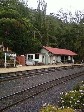
The area is named after a railway station in the area. The Spring Bluff railway station located on the boundary with Lockyer Valley Region local government area, was built in the 1860s to allow trains a place to stop during the steep climb from Brisbane to nearby Toowoomba. In 1890, it was named Spring Bluff after the spring water and the sandstone bluff in the area.[1]
The railway station closed in August 1992. The station and its gardens are heritage listed, and are maintained by a trust consisting of the regional councils of Toowoomba and Lockyer Valley along with Queensland Rail, who also operate a cafe at the site. Due to the floods at Spring Bluff and nearby Murphys Creek in early 2011, the station was closed for repairs for several months.
References
- 1 2 "Spring Bluff (entry 49268)". Queensland Place Names. Queensland Government. Retrieved 28 August 2015.