Spier's School
| Spier's School | |
|---|---|
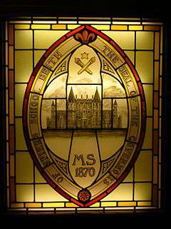 The Seal of the Governors of Spier's school. Note the 'old' architectural design - which was never used, and the date; some 18 years before the school opened. This item is now located at Beith Primary school. | |
| General information | |
| Town or city | Beith, North Ayrshire |
| Country | Scotland |
| Coordinates | 55°44′42″N 4°37′30″W / 55.745°N 4.625°W |
| Construction started | September 1887 |
| Completed | September 1888 |
| Demolished | 1984 |
| Cost | £12,000 |
| Client | John Spier |
| Design and construction | |
| Architect | James Sellars |
Spier's school, at Beith, in North Ayrshire, Scotland, NS 35355327, KA15 1LU, was opened in 1888 and closed in 1972. The school, now demolished, was built using Ballochmyle red sandstone and was reminiscent of the ancient Glasgow University. The school motto was 'Quod verum tutum' (What is true is right).[1] The gardens and woodlands are open to the public at all times.
Sustrans National Route 7 at Kilbirnie Lochside is the nearest cycle-route access. The Barrmill Road entrance is on the bus route from Beith to Barrmill.
History
Site history
Marshalland


Roy's map of 1747 refers to the site as Marchland, indicating that the farm lay on the boundary or march of the Barony of Broadstone within the Lordship of Giffen, and the Barony of Beith, the physical boundary being formed by the Powgree Burn[3] at this point, which is also recorded as the Powgreen or Marshyland burn. Marshalland lay within the Barony of Broadstone.[4] Later maps refer to the site as Marshyland and Marshalland.
The land upon which the school was built in 1858 only shows the presence of two wells and the fields of the old Marshalland farm with its tree lined hedgerows. Tom Paterson and his sister farmed Marshalland in the 1950s, however the last people to live at Marshalland were David and Mary Kerr, the fine house and associated farm buildings being demolished in the early 1960s.[5]
In 1686, John Shedden, ancestor of the Sheddens of Morrishill in Beith, obtained the 14s Lands of Marsheland [sic] from Hugh and John Lyle. He also obtained the 32 Penny Land of Erestoun's Mailling or Burnside of Marsheland.[6] Robert Service bought Marsheland and passed it on to his son Robert. In 1816-17 Robert sold it on to Robert Spier, father of John Spier.[7] Matthew Montgomerie of Bogston's daughter Margaret married John Shedden circa 1700.[8]
John Shedden of Marsheland (sic), born 25 April 1756 was locally known as 'Jack the Marsheland'. He was a notorious poacher of hares at a time when the hunting laws were very strict and archaic. Jack had various brushes with the law and as a result he had to leave the area for a while and became a game-keeper, his local nickname adapting itself to become 'Jack the Gem-Keeper.' When he died he had a friend fire a shotgun over his grave, much to the surprise and consternation of the minister.[7][9]
In around 1820 the part of the Marshal-land (sic) held by Robert Spier had a rent value of £58 18s 2d, whilst that part held by Mrs.Gibson was valued at £20 0s 0d.[10] Aitken's 1829 map shows an R. Spier Esquire as resident at Marsheyland (sic).[11] Andrew Spier, John's brother, is designated 'of Marshalland' and may have lived there until his untimely death.[12] A Marshall family were blacksmiths in Gateside for many generations however no direct connection has been shown to exist.
School history

John Spier was the son of Robert Spier, Writer and bank agent in Beith, owner of the Marshalland and Cuff estates, which included Bogstone, Bellcraig, Eastend of Shutterflat and Lugton Ridge farms. Robert was descended from the Spier's of Kersland Mill,[12] which he purchased from his elder brother and through good business acumen accumulated a considerable fortune of £40,000 in land and money.[13]
Mary Spier Gunn was murdered in Northbank Cottage at Portencross in 1913. This lady was a grand-daughter of Margaret Gibson Spier and the murder remains unsolved to this day.
John Spier of Cuff predeceased his mother, dying in 1858 at the age of 28 in Largs;[14] Margaret Gibson Spier (died, possibly from a carriage accident,[15] in 1870), also from a local family, who followed his wishes and erected a school as a memorial to her son at a cost of £12,000.[16][17] Andrew Spier of Marshalland, John's brother, had also pre-deceased his mother and brother. After many discussions and a Royal Commission investigation,[12] the final plan for a school emerged as a co-educational day school equipped to take a few boarders.

These boarders were always a minor element, never more than 14. They lived in the Head Master's house and wore kilts on weekdays and Eton suits and hats on Sundays. Fees were 50 guineas for full-time boarders; 40 for weekly boarders; and 6 guineas per annum for day-scholars.[18] The 1914-18 War and the shortage of domestic staff resulted in the cessation of boarding at the school. Fees were charged at Spier's, however free education was available to local pupils who passed the qualifying examinations and were recommended by their teachers.

The school's foundation stone was laid in September 1887 in front of more than 1000 visitors[19] and opened on 22 September 1888 with 140 pupils, mostly from North Ayrshire. The boys were taught apart from the girls until 1893 when the extra costs forced a more liberal approach to emerge. Mr. R. Bruce Lockhart from Waid Academy was the first Head Master, followed by Dr Third in 1895. The school administration was in the hands of the Lord Lieutenant of the County, seven representatives of the school boards and the existing trustees as life governors, to be replaced by two heritors of the parish of Beith in due course.
The peak school roll was 310 in 1933 and over 350 after new classrooms were added.[1] By 1932 however the school was in financial difficulties and after a prolonged campaign the County Authorities took over the school in 1937.[1][20] In 1968 the staff consisted of 19 full-time and four itinerant teachers in the Secondary department and two in the preparatory. The school had three 'houses' to which pupils belonged, Cuff, Spier's and Marshalland.[21] The school closed on 30 June 1972 when a modern Garnock Academy was erected at Kilbirnie, taking in the secondary pupils from Spier's, Kilbirnie Central, and Dalry High.[19]
The headmasters were R. Bruce-Lockhart (1888–1895), Dr J. A. Third (1895–1919), Alexander Emslie (1919–1921), Gilbert R. Mair (1921–1937), Robert R. Fairley (1937–1963), and David K. Conn (1963–1972).[22]
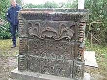
Some of the ornamental stonework was recovered after demolition and now lies near the staff car park at Garnock Academy, Kilbirnie; some of the stones were erected in a commemorative seat. The Speir's school rector's table and chairs, together with a stained glass window and the John Spier statue are also at Garnock Academy.
An initiation tradition for new boy pupils to the secondary department was to be thrown into the pond and then over the wall into Marshalland, known as being 'Ducked and Tossed'.
The school motto was 'Quod verum, tutum' (Anonymous), meaning What is true is right.[23]
The Spier's Institution


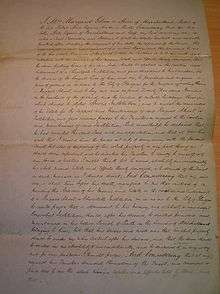
Margaret Gibson Spier's disposition and settlement of 19 March 1869 states that at first a ragged or charitable school near Glasgow was proposed and only later was a school in Beith parish settled on. John Spier, eldest surviving son of Margaret, intended that the school would be a memorial for himself; his mother saw the school as a memorial for her family name, construction to begin within a year of her death. The school would take any religion, except Roman Catholics and a maximum of 24 students, who were not to have pauper or tradesmen parents. Teachers and other staff were to be dismissed if they married, were to retire at 60 with no pension from the trust and if ill they were to pay for a teacher to cover their duties, again no Catholics were to be employed and the Beith presbyterian minister was to make weekly visits of inspection.[24]
John Thomas Rochead of Glasgow was to have been the architect of the school and a very specific requirement was that 'Binny' stone for Edinburgh was to be used in the construction if at all possible. William Brodie was to be the sculptor of the Spier memorial statues and an Italian sculpture of the 'Graces and two cupids', favourite of John spier, was to be permanently housed in the Spier's school board room.[24]
The Spier's Trust


The trust was founded in 1991 by Mr Jack Spiers for the administration of Spier's and for the provision of educational grants and bursaries within the local area of benefit, this being the parishes of Beith, Dalry, Dunlop, Kilbirnie and Neilston. The Trust derives its income from the investment proceeds of the capital of the Trust and from the rental derived from letting for grazing 48.26 acres (195,300 m2) of land adjacent to the former school grounds. The Spiers Trust committee meet twice a year to give out small bursaries to qualifying local students. The Trust committee is made up of the local councillors from Beith, Dalry and Kilbirnie. The total area was 76.3 acres (309,000 m2). North Ayrshire Council now lease the school grounds from the Trust for a nominal rent.[25]
The Margaret Gibson Spier bequest
Recorded in the vestibule of Beith Kirk is the bequest made by Mrs Margaret Gibson or Spier, relict of Robert Spier of Marshalland and Cuff. In addition to the funds for the school she charged her lands of Cuff with a yearly payment of £25 to the Ministers of Beith Kirk. Warm clothing and coals were to be provided to the deserving poor of the town and parish. Margaret died on 17 February 1870.[26] Margaret had also purchased the lands of Bogston and Corshole from Charlotte Decker nee Montgomerie in 1848 and these were part of the foundation endowment of Spier's school.[27] Locally Margaret Spier was known as 'Lady' Spier.[9] She also appears to have wanted to build a hospital, however funds were not available from her estates for such a costly enterprise.[12]
The school buildings


The Barrmill Road entrance is stylistically of 17th century style, comparable to those at Moray House of 1628 in the Canongate, Edinburgh. The entrance is a C Listed structure,[30] as are the boundary walls and the two other gates. The total length of the boundary walls is 937 metres.
Spier's school or college when first completed had a 100-foot (30 m) belltower, hall, boardrooms, 10 classrooms and school-house all designed in the 17th-century style by Campbell Douglas and James Sellars, a Glasgow architectural firm.[31] James Sellars died before the school was completed. The old seal of the governors and a stained glass window (now in Beith Primary School) depicting the seal, shows that a "French middle point" design had originally been intended. The buildings actually constructed were also on a smaller scale than had been intended.[1] The cost was £12,000.[19] An Art room, gymnasium and a Science room were added in 1908, during Dr Third's time.[19] Four Horsa classrooms were added after 1945, being built on the site of the Head Master's garden or orchard. Electricity was installed once the Ayrshire Education authority took charge, however after closure on 30 June 1972 the buildings were subject to vandalism and all the buildings were demolished in 1984.
The Spier's Trust Working Group and the Regional Council made various attempts to find a new use for the buildings, even employing ASSIST, a Glasgow Architectural practice, in 1981. Many suggestions were made, ranging from Country Club to sports academy, but none were ultimately successful for this category 'B' listed building.[32] One proposal, The Spier's Centre, would have had facilities for show jumping, a dry-ski slope, saunas, a solarium, stables, a heritage centre, a cafe, Park Ranger's office, etc. costing £730,000.[33]
The John Spier memorials were moved to the Old Kirk in Beith in the same year.[19][31] The large statue of John Spier which used to stand outside the rector's office was moved to Garnock Academy. The gate piers are C-Listed and the 'tops' were known as the 'Dunces' Caps' by the pupils.[34]
A separate 'Janitor's or Caretaker's' house existed; last occupied by a Mrs.Rae.[33]
School sports


Spier's had a great reputation for playing sports and it was the first school in Ayrshire to play rugby football,[1] as R. Bruce Lockhart, the first headmaster, was a former Vice President of the Scottish Rugby Union.[35] The first game was played at Marshalland on 30 October 1890.[36] As stated, the school had a house system, with Cuff, Marshalland and Spier; providing competition on the school sports days held in June on the Marshalland playing fields. Tennis (girls only), cricket, hockey, net ball and golf were played and a quaint game called targette was played in the early days.
The Old Spierian Football Club, later the Old Spierian Rugby Club, came into existence in 1890.[36] The Garnock Rugby Club came into existence in 1972 as a result of the closure of Spier's and Dalry schools. G.G.H. Johnstone, a maths teacher at Spier's, had founded the rugby club for former pupils and continued his involvement until his death in 1973, at the age of 93.[37] Old Spierians, A.Frew, J. H. Bruce Lockhart, and David Shedden were capped for Scotland.[36]
The 7.28 acres (29,500 m2) 'Marshland' (sic) playing fields are mainly used for football now and facilities are provided in the form of large metal trans-shipment containers based at the car park. A wooden games pavilion existed here in the days of the school.
The World Wars
The school had an unofficial cadet corps in 1914 and donated money to the Belgian Refugee Fund in 1915 and it also endowed a hospital bed in 1918. In the Second World War part of the High Field was converted into a potato field as part of the "Dig for Victory" initiative.
Seventy Old Spierians made the supreme sacrifice and the war memorials were a central feature of the old school buildings. The memorial is now in storage at the North Ayrshire Museum in Saltcoats, awaiting a suitable location for re-erection. The school also had a Garden of Remembrance composed of a rose garden within a square of yew hedges and an internal path. This was under restoration by the YMBB youth group in 2012.
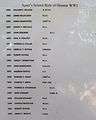
- Role of honour for World War I and World War II


The gardens and woodlands


The Royal Caledonian Horticultural Society list Spier's as an important designed landscape.[38]
The Earl of Eglinton's head gardener at Eglinton Castle laid out the 16.53 acres (66,900 m2) of policies (from the Latin word politus meaning embellished[39]) and gardens. He used a variety of trees and shrubs, especially holly varieties, eventually producing a very fine setting for the school; much of the plantings remain to this day (2008).[40] There were between 50 and 100 varieties of trees within the grounds of Spier's and they used to be labelled with their botanical names.[41] The 1888 order for trees from Samson Nurseries survives and lists the trees ordered for the arboretum as 300 sycamores; 300 Scotch elm; 400 beech; 1000 Scotch fir (sic); 200 Austrian pine; 200 black spruce; 200 black spruce; 50 English elm; 200 Norway maple; 175 limes; 50 English oak; 50 turkey oak; 75 horse chestnut; 50 hornbeam; 200 weeping birch; 100 rhododendron; 100 rowans; and also ash and willows for the hedge.[42]
The walled garden area, internally divided and later used for extra classroom space, was originally an orchard and Kitchen Garden; the entrance off the Terrace Walk at the old Tennis Lawns was used by the female pupils only. The path is described as a 'wheelbarrow road' and the plans for a 'Girls Garden' leading into the Girls' Court survive. The site near the Broadstone Arch with three sides formed from a yew hedge was the World War II Garden of Remembrance and now contains a labyrinth.[42]
An order for the Kitchen Garden lists five espalier pear, six apple, one plum and two cherry varieties for the five foot high walls and twelve standard fruit trees for planting internally. In addition the Kitchen Garden contained gooseberries, blackcurrants, whitecurrants, redcurrants and raspberries.[42]
A 'Coronation Garden' was established here in 1953. The site was close to the tennis lawns which lay next to the school on the Geilsland Road side.
This 1953 Coronation Garden was created with the central feature of the newly discovered "living fossil" tree, the dawn redwood. This tree is very slow growing; it was surrounded by a key shaped edged path network with other ornamental plantings. It was damaged at the top during a money raising drive to fell trees for firewood for sale.55°44.713′N 4°37.505′W / 55.745217°N 4.625083°W
The altitude of the site is between 95 m and 100 m.
The area of woodland near the back entrance to Geilsland School is dominated by a ground layer of ivy and was known as the 'Ivy Palace' to the pupils of Spier's.
The ornamental plantings include the laurel-leaf holly (Ilex aquifolia laurifolia), Highclere holly, (Ilex aquifolia hodginsii),[43] horse chestnut, cedar of Lebanon, yew, the large leaved Persian ivy, (Hedera colchica),[44] cherry laurel, lime, holly, Scot's fir, dawn redwood, ash, monkey puzzle, great leopard's-bane (Dornicum pardalianches), turkey oak, Portuguese laurel[45] and Rhododendron ponticum.
A fine boundary wall surrounds the 16-acre (65,000 m2) site, punctuated by gates which led onto the track which ran on the field's side or onto Barrmill and Geilsland Roads respectively. This wall was extensively repaired and rebuilt by a volunteer, Derek Graham, 2010-11.
The Spier's Trust also owns 48.26 acres (195,300 m2) of grazing land adjacent to the school grounds, including the High Field of 7.25 hectares lying within the school grounds.[46]
The locals know the Powgree as the Geilsland Burn and boys used to play a game of jumping across it from the Broadstone Bridge area down to Marshalland Bridge. The girls used to play in a small area nearby called the 'Fairy Glen.'[47] Robert Aitken on his map of 1827 gives the name as Polgree Burn.[48]
A small cottage near Broadstone Bridge stood near to an old mill and was called 'Crooked Dam' as marked on the 1850s OS map.
Diamond Jubilee Time Capsule
In October 2011 Gateside Primary School pupils placed a 'Wish for the Future' time capsule in the Diamond Jubilee Wood site. This is registered with the International Time Capsule Society (ITCS) at Oglethorpe University in the US. It is due to be opened on 18 June 2037, in the 150 anniversary year of the school's foundation. The pupils have maps of the location and the ITCS have the coordinates.
The Spier's Cholera Pit
In 1829 and 1834 cholera broke out in Beith and although "clothes were burned, bedding fumigated, stairs and closes whitewashed, a nurse who was a veteran of the Dalry outbreak was engaged and a ban placed on entertainments at funerals." There were 100 cases in September 1834, 205 people were eventually affected with 105 deaths. Some of the people were buried in the parish churchyard, but others were buried in a field, in a cholera pit close to what became Spier's School, on the little common south-west of where the Geilsland Road meets the Powgree Burn.[49] Robert Spier, the father of John Spier, was a member of the local health board.[50] The pit had a mound of soil over it at one time however the farmers gradually ploughed this down to the field level.
Diamond Jubilee Wood
In 2012 members of the communities of the Garnock Valley planted a new wood at Spier's to commemorate the Diamond Jubilee of Queen Elizabeth II. Beith Primary School carried out the major part of the planting thanks to the Woodland Trust who donated over 400 trees.
The Spier's Labyrinth and War memorial

Seventy ex-pupils from Spier's died in the First and Second World Wars. A War Memorial was located within the school, however since the demolition of the school no publicly accessible memorial has existed and the old rose garden at the 'Garden of Remembrance' has long been overgrown. In 2012 an old Spier's gatepier was collected, cleaned and placed within the old garden as a War Memorial. The group Youth Making Beith Better (YMBB) created a labyrinth around the standing stone War Memorial as a religious memorial - the 'one true path', etc as found in several cathedrals and in other religious contexts.
Natural history

The grounds had previously been the farmland of Marshalland farm and the evidence from OS maps does not show the presence of any old woodland after the mid-eighteenth century. Several orchid species are present and a few of the indicators species of older woodland. Ivy dominates the ground flora near the Geilsland Road to the extent that almost all other species are eliminated.55°44.781′N 4°37.384′W / 55.746350°N 4.623067°W
Wildlife Site status
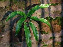
The Scottish Wildlife Trust (SWT) have surveyed the grounds and recorded 19 species of birds and 136 species of plants. The grounds have a rich fungal flora, partly due to the quantity of fallen timber. This is exemplified by the presence of parrot waxcap (Hygrocybe psittacina), an uncommon species. The biodiversity and other considerations have resulted in the grounds qualifying as an official SWT Wildlife Site, code NS353532. This ensures a greater degree of protection against any possibly insensitive developments that might be proposed at any future date. In 2010 a specimen of the Arran whitebeam (Sorbus pseudofennica) a rare species unique to Scotland, was found at Spier's. In 2011 the exceptionally rare common broomrape (Orobanche minor) was discovered growing at Spier's and has been the subject of a conservation project since that date.
The grounds also qualify as a Local Biodiversity Site (LBS). The Scottish Ornithologists Club (SOC) have identified Spier's as a site for birdwatching with, amongst others, tits, finches, thrushes, greater spotted woodpecker, chiffchaff, blackcap, willow and garden warbler.[51] An unusual bird migrant record for the school grounds in the 1920s is that of the mealy redpoll (Carduelis flammea flammea). It breeds across the northern parts of North America and Eurasia.[52]
North Ayrshire Council
The grounds are regularly patrolled by a ranger from the North Ayrshire Ranger Service (District), based at Eglinton Country Park. NACs Streetscene (Grounds Maintenance) Section maintain the grounds of the parkland, mowing grass, removing fallen trees and they also use the site for In Service Training sessions.
In August 2012 Elma Murray, NAC Chief Executive; Joan Sturgeon, Provost; Robert Barr, Deputy provost; and local councillors visited Spier's in recognition of the restoration carried out by community groups. A copper beech tree was planted by the provost to commemorate the visit.
The Spier's Arboretum
Before the Spier family built the school that bore their name, the ancient farmhouse and its lands were called Marshalland. Old maps show that apart from a small patch of woodland around the farm and outbuildings, all the rest was open fields with hedgerow boundaries, probably containing a few mature trees such as beech, ash, birch, and oak. The only other feature at that time was a track leading to the freshwater spring that contributes to the Marshalland Burn close to its source near the Geilsland Road.

In 1888, Spier's School was opened and thanks to the Earl of Eglinton's head gardener, aided by others such as Mr. W. F. Love, the school grounds were planted up with a specially selected list of trees and shrubs creating an arboretum. The tradition of enhancing the grounds continues to this day with memorial and celebratory tree plantings and along the way notable additions have been the exceedingly rare Arran whitebeam, the dawn redwood at the 1953 Coronation Garden, the Camperdown Elm and the Queen Elizabeth II Silver Jubilee Wood of 2012.
The tree order from Samson's Nursery of 20 November 1888 still survives and lists seventeen tree species, but with a total of 3350 trees planted at that time, costing the sum of £9 16s 6d. A fruit trees and shrubs order for the walled garden also survives, listing a total of 371 pears, apples, plums, cherries, gooseberries, currants and raspberries, with several varieties of each.
The walled garden was adapted to house additional classrooms and a gymnasium, resulting in the loss of the orchard, etc. Only a few self-seeded gooseberries and raspberries survive from the original plantings. After its closure in 1972, the school grounds received less maintenance and after the demolition of the school buildings in 1984 even the school 'footprint' itself became a woodland as native colonising trees such as willow, birch, and alder took hold there, providing however a site for the unusual and parasitic broomrape (Orobanche minor) plant, one of Scotland's rarest plants.
In 2010, NAC Streetscene and the North Ayrshire Ranger Service, later joined by the Friends of Spiers (FoS), started a restoration programme that resulted in a network of all-weather and 'user-friendly' paths, followed by a survey of all 812 trees at Spier's and the removal of any deemed dangerous, many felled tree trunks and their stumps however being left as a habitat for insects, fungi, etc.
Extensive tree planting projects involving schools and youth groups were complimented by the planting by NAC Streetscene of a mix of exotic tree species, together with trees selected to further enhance the diversity of the Spier's Arboretum that have been provided through FoS and their 'Memorial' and 'Celebratory' tree planting schemes.
The Spier's Arboretum has a secure future with the prospect of additional species reaching maturity, such as aspen, toffee apple (katsura) tree, handkerchief tree, Wellingtonia, Wollemi pine, holm oak, walnut, fastigiate beech, sessile oak, monkey puzzle, and juniper that will give a total of around fifty tree species in the arboretum.
Leaflets, Facebook, etc.
A tree trail and accompanying leaflet were created in 2013 by the Youth Making Beith Better (YMBB) group to expand the information in the Spier's Old School Grounds leaflet. A Facebook page 'Spier's - Natural and Local History'[53] exists for the benefit of visitors and supporters. The grounds have their own TripAdvisor page that attracts visitor comments and photographs.
Memorials to John Spier and Spier's school


The Spier's Memorial, now at Beith Auld Kirk, described as a "Monumental Shrine" in the RSA Exhibition of 1861, was designed by Frederick Thomas Pilkington, and sculpted by William Brodie. It was originally in the school yard, but later it was incorporated into Campbell Douglas & Sellars school building.
The school is remembered in 'Spiers Avenue' on the Kilbirnie Road. Part of the unmetalled road that runs from Fairholm (Craigvue) down towards Craig House is known as Spiersland Way; the latter part is known as Roughwood Road after the farm of that name. A Spier's care Home also exists in Beith.
Beith Primary school has a 'Spier's Library', a painting of the school and a stained glass window depicting the alternative design of the school, never built, but used on the Governor's official seal. It is dated 1870, 18 years before the school was completed. Gateside Primary school has a Spier's House as well as a Cuff House.
The old War Memorial from Spier's is presently in storage at the North Ayrshire Museum in Saltcoats; the John Spier memorials were moved to the Old Kirk in Beith[19][31] and the large statue of John Spier's was moved to Garnock Academy.
Garnock Academy holds the details of the grant of a Coat of Arms to Spier's, a number of stained glass windows, a mineralogical collection and the rector's old table and chairs from the study. It may also hold the Governor's seal.
Geilsland


This was a half merk land, part of the 4 merk land of Marsheland, in the Barony of Braidstone. It was sold in four lots. In 1867, two of these lots were purchased by Wiliam Fulton Love, writer and bank agent in Beith. He built a handsome villa, in the domestic gothic style,[54] and enclosed and planted with much taste, 5 acres (20,000 m2) around the villa. This property is now part of Geilsland school, run by the Church of Scotland under its 'Crossreach' initiative.[55] The name is pronounced 'Jillsland' locally. The origin of the name may refer to a gil or gyll, referring to a cleft or ravine as found at the 'Fairy Glen' where the Powgree Burn cuts through the fields.
Pupils from Geilsland have helped to improve the grounds of Spier's by carrying out conservation projects.
In 2015 the Church of Scotland ceased to use Geilsland as a school and it was sold to the Beith Development Community Trust Ltd.
Gateside Village
The village of Gateside lies close to Broadstone and Geilsland. It has a fine pub, primary school, plant nursery, Millennium garden, and the Isobel Patrick of Trearne Memorial Hall. Until recently it had a smithy. Trearne House stood nearby and was demolished, the site is now a large limestone quarry.
Industrial and social archaeology
The Moot Hill
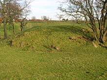
A Moot hill or Court Hill survives near Boghall in the old Barony of Beith. Dobie states that the Abbot of Kilwinning used it to administered justice to his vassals and tenants. It is a sub-oval, flat-topped mound, situated at the foot of a small valley. A number of large stones are visible in the sides of the mound. It is turf-covered, situated on a low outcrop, and is mostly an artificial work. It pre-dates the channelling of the burn which detours around it, the mound was probably isolated in this once marshy outflow of the former Boghall Loch (see NS35SE 14).[56] It does not seem to lie in the area identified by Smith.[57]
Quarrying
A sandstone quarry existed near to Marshalland farm and several sizeable limekilns and limestone quarries lay towards Broadstone; marble was found at Broadstone.[58]
Broadstone castle
The ruins of Braidstone or Broadstone Castle remained until about 1850.[9] but when Broadstonehall Farm buildings were being rebuilt, the castle was pulled down and its stones used in the building works; the Broadstone Crags, the site of the castle, remain however.

Broadstone or Hillhead Limekilns
The OS maps for 1858 show that the 'Hillhead Railway' ran to Broadstone quarry from Barkip Junction on the Ayrshire and Lanarkshire Railway branchline to Kilbirnie. At first sidings and a transfer system existed with a weighing machine at what was to become Brackenhills railway station, later a direct junction was laid. The line did not survive into the 20th century. The road nearby is still known as 'Reek Street'.
Geology
Several large fallen trees at Spier's Old School Grounds have their roots embedded in rock which is derived from an old lava flow known as a 'dike,' one of a 'swarm' that exist locally. The solid geology of the Beith area is dominated by rocks such as limestone, coal, and also whinstone, an igneous basalt. The whinstone is therefore derived from volcanic activity and often shows itself as 'dikes' which are usually linear seams of hardened lava which was originally pushed up through the overlying limestone or coal. Coal miners were greatly inconvenienced by these hard dikes.
The basalt at Spier's has many distinctive holes or bubbles, known as vesicles. These formed when gases such as steam and carbon dioxide escaped as the compressive pressure got less in the molten rock as the lava reached the surface. The largest numbers of bubbles occur when the hardened skin of the lava surface prevented the bubbles from rising to the surface and bursting. Olivine crystal faces are visible, a mineral rich in silica, iron and magnesium. The size of the faces shows that the lava cooled relatively slowly, allowing the crystals time to 'grow'.
Spier's is close to the limestone quarries of Broadstone, Hillhead, Middleton, Dockra and Trearne. Whinstone has been quarried along a dike at Barrmill and is still quarried (2011) at Loanhead.
DM Beith
A large Defence Munitions (DM) centre is located at Beith. The site was originally developed in 1943 as a conventional Royal Naval Armaments Depot, munitions store, for the Royal Navy. It now processes and stores Spearfish, Storm Shadow, Tomahawk and Brimstone missiles. The school lay within the 'Exclusion Zone', limiting new housing developments, etc.[59]
Marshalland Burn
This burn rises from springs within Spier's and runs under the road and field to emerge on the boundary of the Marshalland Playing Fields before entering the Powgree Burn near the old railway bridge at the 'T' junction for the DM Beith site. Polish prisoners of war in World War II used to collect their water from the Marshalland Well close to Bellscauseway and the carbonated water factory at this site may have used these waters to produce 'cooling and temperance drinks'. This enterprise was established in 1891 by Mr T. Murray and produced soda water, aerated water, seltzer, potass, magnesia, lemonade, ginger beer and ginger ale.[60]
The Lands of Roughwood
The Spiersland Way is an old toll road that runs down to Burnside Cottage, probable at one time a smithy, stables and toll house near Roughwood Farm. Roughwood was a small fortified tower in the 15th century and was home sequentially to the Hammills, Sheddens, and Ralston-Patricks.
Micro-history
In 1912 several farms were held by the Spier's Trust and were subject to an official inspection by representatives of the trust. The Cuff, Marshyland, Bellcraig, Bogstone and Lugtonridge were all owned by the trust at this time.[61]
Eglinton Street was formerly known as the Whang or Whang Street and the plot of land at No 62 was feued in 1826 from Lady Mary Montgomerie by Robert Spier. The small chapel in the grounds to the rear was apparently for the family's private use and is probably the same age as the house.[62]
John Spier owned Cuff estate and through his marriage to Margaret Gibson acquired the estate of Marshalland. In 1870 Margaret Spier died and Whang House was purchased by a Thomas Miller.[62]
The rubble from the demolished school was taken to Lyonshields Farm and used to infill an old limestone quarry.[63]
In 1935 a cannon was located at the front of the school as seen in a photograph taken at that time.[64]
The annual Cadger's races of the 19th century were held at the Marshalland Field.
The name 'Pow' or 'Poll' refers to a slow-moving ditch-like stream and this may be appropriate in regard of the name of the burn, the Powgree.[65]
On 11 May 1912 an official inspection by the governors took place of the farms owned by the Spier's Trust, these being Cuff, Marshyland, Bellcraig, Bogston, and Lugtonridge.[66]
A Spier's Knowe is marked on Windy Hill above Largs on the Muirshiel Hills.[67]


The 1st Beith Company (Spier's) Girl Guides was in the 1930s the only Guides group in Beith and was based at Spier's.[68] The Girl Guides had a centre in the field next to the school for some years; the Spier's Trust having sold them 2.2 acres (8,900 m2). This building was repeatedly vandalised. The site was sold and a dwelling built, but after two fires this was also demolished. Only a small building remains, also vandalised.
The 'Old Spierian' records that transport to the school was a regular and severe problem. The 'train students' in particular had to leave home very early and return late.[69]
The 1910 OS map shows a 'Sheepwash' nearly opposite the side entrance to Marshalland farm. A house on the Barrmill Road where it joins the Beith bypass has the unusual name of 'Bellscauseway'. During the depression in the 1930s, times were hard and local people would go up to Spier's School to gather wood for the fire, but as often as not they got 'hunted' by the janitor.[70] A mineral spring known as 'Spiers Well' existed near Gatehead in 1789.[71]
The ghost of John Spier was said to roam the school tower, possibly to discourage students from exploring it, and that of his mother, Margaret Spier, the school grounds. The ornate memorial to John Spier was partitioned off due to its depressing effect on the students.
The Pirritt Hills in Antarctica are named for John Pirritt, Old Spierian, explorer and geologist.[72]
The Powgree Burn name may translate as 'water or marsh (Pow) in an enclose area (Gree)' which is a good description of the area below the Hill of Beith where the Powgree has its source.
Donald Reid records that the school grounds were enclosed and laid out by Mr W. F. Love of Beith.[14]
Restoration of Spier's parklands

The North Ayrshire Council Ranger Service co-ordinated the restoration and enhancement of the Spier's parklands with contributions from Beith and Gateside Primary schools; The Conservation Volunteers; Youth Making Beith Better; James Watt College; Redburn Activity Group; YKG Group; NAC Extended Outreach Group; Garnock Academy; Friends of Spiers; NAC Ranger Service volunteers; Geocachers; Youth Services; Beith Community Council; Geilsland School; Employability Fund Group; Beith Community Council; etc.
Community involvement at Spier's

In 2008 Beith Community Council organised a Spier's School grounds tidy up and improvements morning. Litter was removed and an old path was cleared to allow better access to the site for local people and visitors to the area. Gateside Primary school have planted trees and bulbs donated by the community and Eglinton Country Park. Ardrossan Academy pupils have opened up new paths through the woods and the grounds.
The 'Youth Making Beith Better' group carried out path maintenance and many other grounds improvements works at Spier's through their John Muir Award work. Ken Stewart of Dalry brought Wesley, his Clydesdale horse, to extract logs from the woodlands, providing a spectacle for visitors and removing fallen timber with minimal damage to the habitats. Beith Out of School Care produced publicity posters for the site and the YKG youth group had a BBQ and planted trees. Geilsland School was involved in several projects within the parklands, especially the Coronation Garden restoration.
A Sustainable Return on Investment (SRoI) project was trialed at Spier's, organised by the Greenspace group and part financed by Scottish Natural Heritage.
Friends of Spier's (FoS)
This is a Garnock Valley support group, affiliated to The Conservation Volunteers (TCV).
The Cuff


The Cuff was an estate and later became a farm near Gateside. A marriage stone of the Gibson family gives the date 1767 and may have come from an older mansion house once situated nearby. The farm still has many ornamental and functional entrance gates and gateposts from the Victorian era and magnificent lanes lined with beech trees. Margaret Gibson was an heiress and her son John Spier lived at The Cuff prior to his early death. The Spier are also said to have owned Cuff estate and through Robert Spier's marriage to Margaret Gibson acquired the estate of Marshalland.[62]
References
- Notes
- 1 2 3 4 5 Spiers School. 1888 - 1968.
- 1 2 Logan, Greta (2008), Spier's personal archive material.
- ↑ Douglas, Page 109
- ↑ Dobie, James (1876). Cuninghame topographised by Timothy Pont. Edinburgh : J. Tweed. P. 214.
- ↑ Marshalland farm
- ↑ Dobie, James (MDCCCXVI). Memoir of William Wilson of Crummock. Private Printing. Edinburgh. P. 191.
- 1 2 Dobie, James (MDCCCXVI). Memoir of William Wilson of Crummock. Private Printing. Edinburgh. P. 194.
- ↑ Paterson, James (1863-66). History of the Counties of Ayr and Wigton. IV. - I - Cunninghame. Edinburgh: J. Stillie. p.82
- 1 2 3 Porterfield, S. (1925). Rambles Round Beith. P. 31.
- ↑ Robertson, George (1820). A Topographical Description of Ayrshire; more particularly of Cunninghame. Irvine : Cunninghame Press.
- ↑ Aitken, Robert (1829). The Parish Atlas of Ayrshire - Cunninghame. Edinburgh : W. Ballantine.
- 1 2 3 4 Dedication Speech of the Spier School by B. W. Cochran-Patrick of Ladyland & Woodside. 28 April 1887.
- ↑ Spier's School Magazine, No.1, December 1888. P. 2
- 1 2 Reid (2001), Page 96
- ↑ Gilbert, Thomas & Grace (2010). Windyhouse Farm.
- ↑ Groome, Francis H. (1903). Ordnance Gazetteer of Scotland. London : Caxton. p. 138.
- ↑ Pride, David (1910). A History of the Parish of Neilston. Paisley: Alexander Gardner. pp. 132 - 133.
- ↑ Reid, Donald L. & Monahan, Isobel F. (1999). Yesterday's Beith. A Pictorial Guide. Beith : Duke of Edinburgh Award. ISBN 0-9522720-5-9. P. 79.
- 1 2 3 4 5 6 Love, Dane (2005) Lost Ayrshire. Ayrshire's Lost Architectural Heritage. Pub. Birlinn Ltd. ISBN 1-84158-356-1. p. 171.
- ↑ Reid, Donald L. & Monahan, Isobel F. (1999). Yesterday's Beith. A Pictorial Guide. Beith : Duke of Edinburgh Award. ISBN 0-9522720-5-9. P. 91.
- ↑ Gardner, Margaret (2008). Oral information from an ex pupil. Eglinton Archive.
- ↑ Reid, Donald L. (2000). Old Beith. Ochiltree : Stenlake. ISBN 1-84033-126-7 p. 31
- ↑ "Right Hand Pointing: Short Poetry, Short Fiction, and Short Art".
- 1 2 Spier's Trust.
- ↑ Guidance note on Spier's Trust Committee (Spier's Trust Scheme 1978) North Ayrshire Council.
- ↑ The High Church, Beith. An Illustrated Historical Guide. 1983. Appendix 2. P. 51.
- ↑ Dobie, James (MDCCCXVI). Memoir of William Wilson of Crummock. Private Printing. Edinburgh.
- ↑ Billings, Robert William (1901). The Baronial and Ecclesiastical Antiquities of Scotland. Vol.II. Pub. Oliver & Boyd. Edinburgh.
- ↑ Speir's School Magazine, No. 21, April, 1891
- ↑ Stuff, Good. "Barrmill Road, Gatepiers, Railings and Boundary Walls to Former Spier's School - Beith - North Ayrshire - Scotland - British Listed Buildings".
- 1 2 3 "Historic Environment Scotland".
- ↑ Ayrshire Life magazine. Unique Building. March - April 1984. P. 10 -12.
- 1 2 Records management Unit. North Ayrshire Council. Perceton House.
- ↑ Hart, Thomas. Oral Communication. January 2008.
- ↑ Kinniburgh, Page 96
- 1 2 3 Kinniburgh, Page 97
- ↑ Garnock Rugby Club.
- ↑ Royal Caledonian Horticultual Society.
- ↑ Ayrshire. A Survey of Gardens and Designed Landscapes. Peter MCGowan Associates with Christopher Dingwall. March 2007.
- ↑ The Old Spierian. Centenary edition. 1887–1987. P. 5.
- ↑ Hugh Stevenson's recollections of old Beith.
- 1 2 3 Eglinton Archive
- ↑ Mitchell, Alan (1985). Trees of Britain and North Europe. Pub. Guild. P. 88 - 89.
- ↑ Hessayon, D. G. (1983). The Tree and Shrub Expert. pbi Publications. ISBN 0-903505-17-7. P. 76
- ↑ Clapham, A. R., Tutin, T. G., and Warburg, E. F., (1963). Flora of the British Isles. Illustrations. Part III. Boraginacea - Compositae. Pub. Cambridge University Press. P. 78.
- ↑ NAC Records Management Unit. Perceton Archive.
- ↑ Reflections on Beith and District. On the wings of time. (1994). Pub. Beith High Church Youth Group. ISBN 0-9522720-0-8. P. 31.
- ↑ Aitken, Robert (1827), Map of the Parish of Beith.
- ↑ Porterfield, S. (1925). Rambles Round Beith. P. 36.
- ↑ Cholera deaths in Beith
- ↑ Birdwatching in Ayrshire and Arran. No. 28. Spier's School Grounds. 2003.
- ↑ Paton, E. Richmond and Pike, Oliver G. (1929). The Birds of Ayrshire. London : H. F. & G. Witherby. p. 19.
- ↑ "Security Check Required".
- ↑ Davis, Michael (1991) The Castles and Mansions of Ayrshire. Pub. privately. P. 97.
- ↑ schools, isbi. "Geilsland School - Beith - Ayrshire, Scotland - KA15 1HD".
- ↑ "Historic Environment Scotland".
- ↑ Smith, John (1895). Prehistoric Man in Ayrshire. Pub. Elliot Stock. P. 81.
- ↑ Robertson, George (1820). A Topographical Description of Ayrshire; more particularly of Cunninghame. Irvine : Cunninghame Press, Irvine. p. 281.
- ↑ DM Beith
- ↑ Reid (2001), Page 68
- ↑ Reid, Page 84
- 1 2 3 Stuff, Good. "62 Eglinton Street, Whang House, Including Ruined Chapel to Rear, Boundary Walls and Gatepiers - Beith - North Ayrshire - Scotland - British Listed Buildings".
- ↑ Gilbert,
- ↑ Friends Reunited Retrieved : 2011-11-07
- ↑ Strawhorn, Page 36
- ↑ Reid, Donald L. & Monahan, Isobel F. (1999). Yesterday's Beith. A Pictorial Guide. Beith : Duke of Edinburgh Award. ISBN 0-9522720-5-9. P. 84.
- ↑ Ordnance Survey Retrieved : 2010-12-06
- ↑ Reid, Donald L. and Monahan, Isobel F. (1999). Yesterdays Beith, a pictorial guide. Beith : DoE Award Scheme. ISBN 0-9522720-5-9 P. 12
- ↑ The Old Spierian. Centenary edition. 1887 - 1987.
- ↑ The 1930s In Beith
- ↑ National Archives of Scotland. RHP3 / 37.
- ↑ Reid, Donald L. and Monahan, Isobel F. (1999). Yesterdays Beith, a pictorial guide. Beith : DoE Award Scheme. ISBN 0-9522720-5-9 P. 110
- Sources
- Douglas, William Scott (1874). In Ayrshire. A Descriptive Picture of the County of Ayr. Kilmarnock : McKie & Drennan. Reprint. ISBN 978-1-4097-1645-7.
- Gilbert, Tom (2012). Personal recollection.
- Trust Disposition and Settlement by Margaret Spier of Marshalland. 19 March 1869.
- Kinniburgh, Moira & Burke, Fiona (1995). Kilbirnie & Glengarnock. Shared Memories. Cunninghame District Council. ISBN 1-897998-01-5.
- Reid, Donald L. (2000). The Beith Supplement - The Story of Beith's Newspaper. Beith : Duke of Edinburgh Award. ISBN 0-9522720-1-6.
- Reid, Donald (2001). In the Valley of the Garnock (Beith, Dalry & Kilbirnie). Beith : DoE. ISBN 0-9522720-5-9.
- Strawhorn, John (1994). The History of Prestwick. Edinburgh : John Donald. ISBN 0-85976-405-2.
External links
![]() Media related to Spier's School at Wikimedia Commons
Media related to Spier's School at Wikimedia Commons
- The Spier's Natural & Local History site.
- Spier's Asiatic Cholera Pit.
- In Memory of Geilsland School (1964-2014)
- WWI Trench Reconstruction on the High Field at Spier's.
- Kersland Glen and the Tianna Falls on the Powgree Burn.
- Honey or Boot-lace Fungus at Spier's'
- The History of Spier's Old School Grounds - Part 2.
- The History of Spier's Old School Grounds - Part 1.
- SNAPS Video of the High Field at Spier's.
- Video of an oscillant at Spier's.
- Video of the common broomrape plants at Spier's.
- Video of the Arran whitebeam at Spier's.
- Video of the Coronation Garden.
- Video and narration about lesser celandine.
- Friends Reunited - Spiers School.
- Spier's School magazine pages Accessed : 2010-11-18.
- British Listed Buildings.
- NAC Spier's Site. Accessed : 2010-07-31.
- Garnock Rugby Club. Accessed : 2010-04-25.
- Sustrans Cyclepaths. Accessed : 2010-03-31.
- Friends of Spiers Blog.
- Spier's on Construction News.
- A sporty photo at Spier's.
- Speir family Genealogy and History Site.
- Old Spierian's reunion and photographs.
- Beith Online reports on Spier's Old School.
- A photograph of Senior pupils at Spier's school.
- A Map of Beith.
- General Roy's Military Survey of Scotland 1747 - 52.
- Old maps of Scotland from the National Library.
- Old Ordnance Survey Maps.
- Wikibooks:A Researcher's Guide to Local History Terminology A Researcher's Guide to Local History terminology.