Sperrgebiet
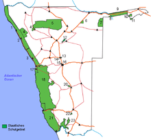
The Sperrgebiet (German, meaning "Prohibited Area") (also known as Diamond Area 1) is a diamond mining area in southwestern Namibia, in the Namib Desert. It spans the Atlantic Ocean-facing coast from Oranjemund on the border with South Africa, to around 72 kilometres (45 mi) north of Lüderitz, a distance of 320 km (200 mi) north. The Sperrgebiet extends to around 100 km (62 mi) inland,[1] and its total area of 26,000 km2 (10,000 sq mi),[2][3] makes up three percent of Namibia's land mass.[4] However, mining only takes place in five percent of the Sperrgebiet,[5] with most of the area acting as a buffer zone.[6] Members of the public are banned from entering most of the area, despite the creation of a national park there in 2004.[7]
History
.jpg)
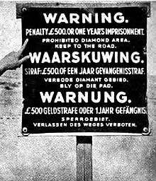
In September 1908,[8] the German government created the Sperrgebiet in its colony of German South-West Africa, giving sole rights for mining to the Deutsche Diamantengesellschaft ("German Diamond Company"). In 1915, during World War I, South African forces led by General Jan Smuts and Louis Botha, the South African Prime Minister, invaded the country. The South Africans defeated the Germans, taking control of modern-day Namibia, including the Sperrgebiet.[9] The owner of the mine, De Beers (see The Case of the Disappearing Diamonds 1987 TV documentary), had total control of the area until the 1990s, when the Namibian government purchased a fifty percent stake. They formed a joint partnership called the Namdeb Diamond Corporation.[3]
Nature
The Sperrgebiet has a diverse range of flora and fauna, due to little human intervention in the area for 100 years. Forty percent of the landscape is desert, thirty percent is grassland, and twenty-eight percent is rocky.[10] The highest point of the Sperrgebiet is 1488m.[10]
There are 776 types of plants in the Sperrgebiet, with 234 being endemic to southwest Namibia, despite the Orange River being the only permanent water supply in the area.[3] A study has shown that climate change will affect the plant life in the area, specifically the Succulent Karoo. Drier winters may lead to the extinction of these plants, as they are endemic to the Sperrgebiet.[11] According to Morgan Hauptfleisch, a scientist who works at the Southern African Institute for Environmental Assessment, the Sperrgebiet "is the only arid biodiversity hotspot and this makes it a very special area".[2] It has more biodiversity than anywhere else in Namibia, supporting animals such as the gemsbok, springbok, and brown hyena.[12] Bird species resident in the Sperrgebiet include the African oystercatcher, the black-headed canary, and the dune lark.[10]
National park and recent history
The Sperrgebiet was designated as a national park in June 2004. De Beers still controls the area, but will relinquish control to the Namibian Ministry for Environment and Tourism once a management plan for the park has been completed.[2] In April 2008, a 500-year-old shipwreck containing Iberian coins, bronze cannons, copper, and ivory was found in the Sperrgebiet.[13] Under Namibian law, the Namibian government is entitled to all the items found on board.[14] Today, there are several ghost towns in the Sperrgebiet, built in the late 19th century. The wind has partially excavated a number of half-mummified bodies at a graveyard outside one of these ghost towns.
Literature
- Noli, Gino: Desert Diamonds. Gino Noli, Plettenberg Bay 2010, ISBN 978-0-620-40680-2.
References
- Christian Goltz (2012). Sperrgebiet National Park Visitor's Information Materials
- ↑ "Sperrgebiet". Encyclopædia Britannica. Retrieved 2008-05-23.
- 1 2 3 Absalom Shigwedha (2008-03-06). "Scoping the Sperrgebiet". The Namibian. Retrieved 2008-05-23.
- 1 2 3 "Namibia Declares Sperrgebiet As National Park". Critical Ecosystem Partnership Fund. June 2004. Archived from the original on November 8, 2007. Retrieved 2008-05-24.
- ↑ Donald G. McNeil Jr. (1998-04-27). "Oranjemund Journal; Find a Diamond in the Sand? Just Don't Pick It Up (2)". New York Times. Retrieved 2008-05-23.
- ↑ Hardy, Paula; Firestone, Matthew D. (2007). Lonely Planet Botswana & Namibia. Lonely Planet. p. 218. ISBN 1-74104-760-9. Retrieved 2008-05-23.
- ↑ Donald G. McNeil Jr. (1998-04-27). "Find a Diamond in the Sand? Just Don't Pick It Up (1)". New York Times, reprinted in Oranjemund Journal. Retrieved 2008-05-23.
- ↑ Hardy, Paula; Firestone, Matthew D. (2007). Lonely Planet Botswana & Namibia. Lonely Planet. p. 358. ISBN 1-74104-760-9. Retrieved 2008-05-23.
- ↑ Santcross, Nick; Ballard, Sebastian; Baker, Gordon. Namibia Handbook: The Travel Guide. Footprint Books. ISBN 1-900949-91-1. Retrieved 2008-05-24.
- ↑ Hardy, Paula; Firestone, Matthew D. (2007). Lonely Planet Botswana & Namibia. Lonely Planet. p. 203. ISBN 1-74104-760-9. Retrieved 2008-05-23.
- 1 2 3 "BirdLife IBA Factsheet NA019 Sperrgebiet". BirdLife International. Retrieved 2008-05-24.
- ↑ Absalom Shigwedha (2008-04-10). "Plants in Sperrgebiet Area At Risk". The Namibian. Retrieved 2008-05-24.
- ↑ "Succulent Karoo Ecosystem Programme". Rufford Maurice Laing Foundation. Retrieved 2008-05-24.
- ↑ John Grobler (2008-05-04). "The body and loot of Dias?". Mail & Guardian. Retrieved 2008-05-24.
- ↑ Chamwe Kaira (2008-04-30). "De Beers Finds Shipwreck, Treasure From Columbus Era (Update2)". Bloomberg News. Retrieved 2008-05-24.
Coordinates: 26°40′30″S 15°05′24″E / 26.675°S 15.090°E
| Wikimedia Commons has media related to Sperrgebiet. |