Spaulding Turnpike
| |
|---|---|
|
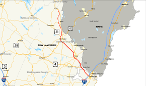
Map of eastern New Hampshire with Spaulding Turnpike highlighted in red | |
| Route information | |
| Maintained by NHDOT | |
| Length: | 33.2 mi[1] (53.4 km) |
| Existed: | ca. 1956 – present |
| Major junctions | |
| South end: |
|
|
| |
| North end: |
|
| Location | |
| Counties: | Rockingham, Strafford |
| Highway system | |

The Spaulding Turnpike is a 33.2-mile (53.4 km) north-south highway in eastern New Hampshire. Nearly its entire length is overlapped by New Hampshire Route 16. Its southern terminus is at the Portsmouth Traffic Circle (Interstate 95 / U.S. Route 1 Bypass) in Portsmouth, a terminus it shares with U.S. Route 4 and NH 16. Its northern terminus is at an interchange with New Hampshire Route 125 in Milton, where NH 16 continues north as a full-access highway.
The Turnpike roughly parallels the Maine border. NH 16 was signed onto the Turnpike in the mid-1990s.
The Turnpike is part of the New Hampshire Turnpike System operated by the New Hampshire Department of Transportation Bureau of Turnpikes. Along with I-95 between the Massachusetts state border and the Portsmouth Circle (Blue Star Turnpike), the two turnpikes are collectively known as the Eastern Turnpike.
Route description
The Spaulding Turnpike begins in Portsmouth, at I-95 northbound exit 4. Access from I-95 south and US 1 Bypass is facilitated via exit 5 (Portsmouth Traffic Circle). A northbound-only exit connects with Brady Drive, accessible only from the traffic circle. The Spaulding Turnpike becomes a six-lane freeway concurrent with US 4 and NH 16, with a 50 mph (80 km/h) speed limit. Exit 1 in Newington provides access to Pease International Tradeport and the Newington malls. The Turnpike expands to 4 lanes just north of exit 1.
Exit 2, a northbound only exit/entrance which facilitated access to The Mall at Fox Run and adjacent businesses, was closed permanently on July 16, 2015. Exit 3 is a recently upgraded full-access interchange with Woodbury Avenue, with a connection to Pease Tradeport via Arboretum Drive. The newly upgraded interchange opened for traffic in fall 2015. Currently, the turnpike narrows to 2 lanes just north of exit 3, although the roadway is being expanded as far north as exit 5.
.jpg)
Exit 4 provides access to Newington Village and industrial areas along Shattuck Way. The Turnpike then crosses the Little Bay Bridge into Dover.
Exit 5 (currently closed for construction, scheduled to reopen in late 2015) provides access to Hilton Park and Wentworth Terrace. This exit will also be permanently closed in 2018 as part of a reconstructed exit 6 interchange.
US 4 leaves the Turnpike at exit 6 (Dover Point Road), with the Dover barrier toll located just to the north. Currently there is no access from eastbound US 4 to the northbound Turnpike, nor from the southbound Turnpike to Dover Point Road north. Traffic is directed to exit 4 (Newington Village) to reverse direction. Exit 6 is scheduled to be reconstructed in 2018 to allow for full access in all directions, including connections to Hilton Park and Wentworth Terrace.
North of the toll plaza, the speed limit increases to 55 mph (89 km/h) and the freeway passes west of downtown Dover. Exits 7-9 provide local access via NH 108, NH 9 and Indian Brook Drive, respectively. A park and ride facility is located on Indian Brook Drive just off exit 9. North of exit 9 the speed limit increases to 65 mph (105 km/h).
The Turnpike continues north and crosses into Rochester, reaching the Rochester barrier toll soon after. The freeway expands to three lanes north of exit 12 and bypasses downtown Rochester to the west. US 202 joins the freeway at exit 13, near the site of another park & ride facility built in 2014. NH 11 also joins the Turnpike 1.6 miles (2.6 km) to the north at exit 15. Both US 202 and NH 11 depart the Turnpike at exit 16 towards East Rochester. Continuing north, the freeway narrows into a Super-2 and the speed limit drops back to 55 mph (89 km/h).
The highway continues north into Milton, with exits 17 and 18 providing local access via NH 75 and NH 125. The Spaulding Turnpike designation ends at exit 18 near Union; NH 16 continues north as a full-access highway.
Tolls
Two barrier tolls are present on the Spaulding Turnpike - one in Dover and one in Rochester. Travel south of exit 6, north of exit 11, and between the barrier tolls (exits 7-9 in Dover) is free of charge.
Toll rates
Toll rates are determined by the class of vehicle (number of axles, single or dual rear tires). The NHDOT currently offers discounted tolls for customers utilizing EZ-Pass transponders. The discount rates are 30 percent for Class 1-4 vehicles (single rear tires) and 10 percent for Class 5-12 vehicles (dual rear tires).
| Class | Vehicle description | Cash Fare | EZ-Pass Fare |
|---|---|---|---|
| 1 | 2 axles, single rear tires | $0.75 | $0.53 |
| 2 | 3 axles, single rear tires | $1.00 | $0.70 |
| 3 | 4 axles, single rear tires | $1.25 | $0.88 |
| 4 | 5 axles, single rear tires | $1.50 | $1.05 |
| 5 | 2 axles, dual rear tires | $1.50 | $1.35 |
| 6 | 3 axles, dual rear tires | $2.00 | $1.80 |
| 7 | 4 axles, dual rear tires | $2.50 | $2.25 |
| 8 | 5 axles, dual rear tires | $3.00 | $2.70 |
| 9 | 6 axles, dual rear tires | $3.50 | $3.15 |
| 10 | 7 axles, dual rear tires | $4.00 | $3.60 |
| 11 | 8 axles, dual rear tires | $4.50 | $4.05 |
| 12 | 9 axles, dual rear tires | $5.00 | $4.50 |
Southern terminus
Signage on I-95 suggests that the Spaulding Turnpike, NH 16 and US 4 all terminate at the same point. However:
- Milepost readings indicate that the Turnpike begins on the exit 4 northbound offramp from I-95, approximately 1⁄4 mile (0.40 km) north of the split, and runs by itself for approximately 0.8 miles (1.3 km) before joining NH 16. Similarly, mileposts for the southbound Turnpike continue along the ramp to I-95 south, ending at "Mile 0" approximately 1⁄4 mile (0.40 km) before the merge onto I-95 southbound.
- Signage at the Portsmouth Circle for the freeway reads "NH 16 North to Spaulding Turnpike/US 4." This implies that NH 16 begins at the circle and approaches the turnpike from the right. Southbound ground signage formerly indicated NH 16 continuing at the left-hand split for I-95 north and US 1 Bypass to terminate at the traffic circle, but new signage has since been installed omitting NH 16.
- The first westbound signage for US 4 is after the Spaulding Turnpike and NH 16 join. The last eastbound signage is immediately south of exit 1, before the split for I-95. No end signage is present.
Exit list
| County | Location | mi | km | Old exit[2][3] | New exit | Destinations | Notes |
|---|---|---|---|---|---|---|---|
| Rockingham | Portsmouth | 0.00– 0.77 | 0.00– 1.24 | — | Portsmouth Traffic Circle; southern terminus of Spaulding Turnpike / NH 16; eastern terminus of US 4 | ||
| 0.92 | 1.48 | — | Brady Drive | Northbound exit and entrance; access from Portsmouth Circle only | |||
| Newington | 1.59 | 2.56 | 1 | Gosling Road – Pease International Tradeport | |||
| 2.38 | 3.83 | 2 | Fox Run Road | Permanently closed July 16, 2015. Access via exits 1 or 3. | |||
| 2.86 | 4.60 | 3 | Woodbury Avenue | Formerly southbound exit/northbound entrance, now a full-access interchange with a connection to Arboretum Drive on Pease International Tradeport. | |||
| 3.45 | 5.55 | 4 | Shattuck Way – Newington Village | ||||
| Strafford | Dover | 4.39 | 7.07 | 5 | Hilton Park | Northbound exit and entrance Scheduled for permanent closure in fall 2018 after reconstruction of exit 6. | |
| 4.76 | 7.66 | 3 | 6 | Northern terminus of US 4 concurrency; signed as exit 6W northbound. No access from US 4 east to Spaulding Turnpike north. Full-access interchange scheduled for construction starting in summer 2016 | |||
| 5.01 | 8.06 | 6N | Dover Point Road – Dover | No southbound access - must use exit 4 to reverse direction | |||
| 5.5 | 8.9 | Dover toll plaza (Class 1 vehicles: $0.75 cash / $0.53 EZ-Pass) | |||||
| 9.14 | 14.71 | 4 | 7 | ||||
| 9.45 | 15.21 | 5 | 8 | Signed as exits 8E and 8W | |||
| 12.24 | 19.70 | 6 | 9 | ||||
| Rochester | 17.3 | 27.8 | Rochester toll plaza (Class 1 vehicles: $0.75 cash / $0.53 EZ-Pass) | ||||
| 18.20 | 29.29 | 11 | Old Dover Road – Rochester | Northbound exit only | |||
| 18.45 | 29.69 | 7 | 12 | ||||
| 19.66 | 31.64 | 8 | 13 | Southern terminus of US 202 concurrency | |||
| 20.76 | 33.41 | 9 | 14 | Ten Rod Road – Rochester | Northbound exit/southbound entrance | ||
| 21.26 | 34.21 | 10 | 15 | Southern terminus of NH 11 concurrency | |||
| 22.02 | 35.44 | 16 | Northern terminus of US 202 / NH 11 concurrency | ||||
| Milton | 27.40 | 44.10 | 17 | ||||
| 33.11 | 53.29 | 18 | |||||
| 33.2 | 53.4 | Northern terminus of Spaulding Turnpike; NH 16 continues north | |||||
1.000 mi = 1.609 km; 1.000 km = 0.621 mi
| |||||||
Concurrent routes
- U.S. Route 4: 4.76 miles (7.66 km), Portsmouth to Dover
- U.S. Route 202: 2.36 miles (3.80 km), Rochester
- New Hampshire Route 11: 0.76 miles (1.22 km), Rochester
See also
References
- ↑ NHDOT Bureau of Turnpikes - Spaulding Turnpike
- ↑ USGS, 1956 Dover quadrangle
- ↑ USGS, 1958 Berwick quadrangle