Sozh River
| Sozh | |
|---|---|
 | |
| Country | Belarus, Russia, Ukraine |
| Basin | |
| Main source | Russia |
| River mouth | Dnieper |
| Basin size | 42,140 km2 (16,270 sq mi) |
| Physical characteristics | |
| Length | 648 km (403 mi) |
| Discharge |
|

Sozh (Belarusian: Сож, [sɔʐ]; Russian: Сож, Ukrainian: Сож, Polish: Soż) is an international river flowing in Belarus, Russia and Ukraine. It is a left bank tributary of the Dnieper River. Sozh passes through Gomel, the second largest city in Belarus.[1]
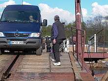
The river is crossed by the Sozh Floating Bridge at Korma and an elegant steel arch at Gomel, which is featured on a national stamp of 300 ruble value.[2]
Etymology
The original name was Sozh' (Russian: Сожь), from Old East Slavic Съжь. With the previously suggested Baltic and Finnic etymologies considered unsatisfactory, Vadim Andreevich Zhuchkevich proposed that the name is derived from Old Russian/Old Belarusian sozhzh' (сожжь) 'burned parts of a forest prepared for plowing,' which has parallels to other place names.[3]
Geography
The Sozh River rises in Russia and is mostly snow fed. The river freezes over between November and early January. The ice thaws from late March or April. Pronia, on the right, and the Oster, Besed’, and Iput’, on the left are its main tributaries.[1] It is one of the six tributaries longer than 500 km which join the Dnieper River – the third longest river (2,201 km) in Europe.[4]
The river is provided with navigational locks in its upper reaches where it is navigable from Krichev. Timber is floated along the river.[1]
The mouth of the river is very broad (about 10 km) and swampy. The catchment area of the river is 42,140 square kilometres (16,270 sq mi) along its 648 kilometres (403 mi) length, 21,700 square kilometres (8,400 sq mi) and 493 kilometres (306 mi) within Belarus.[5] The mean discharge recorded at Gomel, 100 kilometres (62 mi) upstream from the mouth, is 207 m3/s.[1][6]
Important historical towns on the banks of main river and its tributaries are: Krichev, Cherikov, Slavgorod, Gomel and Vetka.[1][7]:209[8]
History

Many of the cities and towns located in the river valley are part of the river's history of events. Several centuries ago, Radimichi tribal people lived in the Sozh River basin and established the Gomel town. They were involved in agricultural practices, rearing cattle, fishing and honey collection. They were craftsmen, and they were good tradesman as the river provided navigation to the northwestern and southeastern parts of Europe.[9] Gomel, a river port and a railhead, is also known as Homyel or Homiel. It is situated to the southeast of Belarus, and is the capital (administrative centre) of the Homyel Oblast. It is located on the western bank of the Sozh River, about 300 km from Minsk, and close to the border with Russia and Ukraine. The earliest reported occupation of the town was in 1142, under Kievan Rus. This was followed by Lithuanian control in 1537, then Polish under the Treaty of Andrusov, and later under Russia in 1772. Embankments were built on the banks of the Sozh River . As a result, "a unique nature-architecture ensemble grew on the high picturesque bank of the Sozh River right in the historical center of Gomel." These monuments are credited to the Rumyantsevs and the Paskeviches who were statesmen and military commanders of the Russian Empire.[10] The town is now an important industrial center with a population of about half million.[7]:197[11][12] Located in the region of the Chernobyl disaster, Gomel and its surrounding area still suffers from subsisting levels of radiation.[7]:197

Vetka is a small town, 22 kilometres (14 mi) northeast of Gomel, surrounded by forest and marshy land. It was gutted twice by invading Tsarist forces in 1735 and 1764 which forced the residents to resettle in Eastern Russia. It was renowned for the unique icon style paintings and also wood carvings. It was annexed by the Russian Empire, in 1852. Ships were manufactured here from 1840. During World War II, the town was occupied by the Nazis who killed many of the residents. Vetka, on the Sozh River, is located in an area radioactively polluted as a result of the Chernobyl disaster that occurred on 26 April 1986.[13] High radiation levels due to iodine-131 (20,000 kBq/m2) and strontium-90 (137 kBq/m2) were measured in the soil in the entire Vetka district after the accident.[14] This disaster also resulted in a large-scale relocation of population. A Folk Art Museum, founded in 1987, has exhibits depicting the ancient artefacts, carved wooden entrance doors, manuscripts, traditional costumes and woven rushniki.[7]:209
Anthropomorphized forms of Russian myths include tales of rivalry between the Sozh, described as wild and turbulent, and the Dnieper, which is described as quiet and leisurely.[15]
Archaeological excavations
Excavations have unearthed a Palaeolithic boat in the soils of the Sozh River, which has been preserved in the Museum of Ancient Belarusian Culture.[7]:118 The remains of pantheist temples were excavated in the mounds of Tushemlia and Haradok on the Sozh River and dated to the 3rd and 4th centuries. These temples have been inferred as temples erected by Balts for worship of gods and goddesses. Through the end of the 14th century, during the Grand Duchy of Lithuania period, pantheistic religion was prevalent in the region.[16] Another Palaeolithic site, discovered by Konstantin Mikhailovich Polikarpovich, is located on the hill above the bank of Sozh river, in Berdizh village.[17] Remains of woolly mammoth have also been found along the Sozh River.[18]
Economy
Sozh River deposits that extend into Smolensk Oblast providing a supply of ground phosphate to Krichev and Klimovichi rock plants.[19] Phosphorite is found along the river between Mstislavl and Krichev. Many other construction materials, such as chalk, clay, sand, and gravel are also distributed in the river region as are many mineral water springs.[8] The Sozh is one of the two chief rivers of Mogilev in the Smolensk Oblast where the trade in the early part of the 20th century, involving primarily paper, oil, wire nails, flour, glass, and matches, was predominantly in the hands of the large Jewish population.[20]
Gallery
 Bluff of the Sozh River (Сож) in eastern Belarus
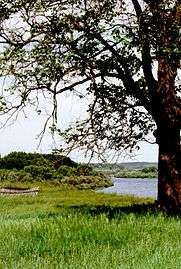 The Sozh River in eastern Belarus
References
- 1 2 3 4 5 "Sozh". The Great Soviet Encyclopedia, 3rd Edition (1970–1979). Retrieved 2 February 2011.
- ↑ "Bridges of Belarus". FSU Postage Stamps Catalogue. Retrieved 2011-02-02.
- ↑ Pospelov, Evgenij Michajlovič (1998). Geograficeskie nazvanija mira : toponmiceskij slovar (in Russian). Moskav: Russkie Slovari. p. 390.
- ↑ Klement Tockner; Urs Uehlinger; Christopher T. Robinson (2009). Rivers of Europe. Academic Press. pp. 522–. ISBN 978-0-12-369449-2. Retrieved 3 February 2011.
- ↑ "Main Geographic Characteristics of the Republic of Belarus. Main characteristics of the largest rivers of Belarus". Land of Ancestors. Data of the Ministry of Natural Resources and Environmental Protection of the Republic of Belarus. 2011. Retrieved 27 September 2013.
- ↑ "Dnieper River". Encyclopedia of Ukraine. 1984. Retrieved 2 February 2016.
- 1 2 3 4 5 Nigel Roberts (2008). Belarus. Bradt Travel Guides. ISBN 978-1-84162-207-1. Retrieved 2 February 2016.
- 1 2 "Belarus City". Belaruscity.net. Retrieved 2 February 2011.
- ↑ "Gomel: Then & Now: Gomel's History". Gomel.lk.net. Archived from the original on 3 February 2012. Retrieved 2 February 2011.
- ↑ "The levee of the Sozh River". Gomel Palace & Park Ensemble. 2009. Retrieved 2 February 2011.
- ↑ "Homyel". Encyclopedia Brittanica. Retrieved 2 February 2011.
- ↑ "Gomel". Encyclopedia.com. Retrieved 2 February 2011.
- ↑ "Vetka". Belarus tourism- A national Tourism Agency. Retrieved 2 April 2011.
- ↑ "Vetka District". chernobyl.info. Archived from the original on 2010-11-22. Retrieved 2 April 2011.
- ↑ Warner, Elizabeth (1 July 2002). Russian myths. University of Texas Press. pp. 24–. ISBN 978-0-292-79158-9. Retrieved 5 February 2011.
- ↑ "Heavenly Bodies and Phenomena in the Baltic Religion". Romuvainfo. Archived from the original on 6 September 2010. Retrieved 2 February 2011.
- ↑ Tage Skogsberg; Austin Phelps (1938). Hydrography of Monterey Bay California: Thermal conditions. American Philosophical Society. Retrieved 3 February 2011.
- ↑ Kipfer, Barbara Ann (2000). Encyclopedic dictionary of archaeology. Springer. p. 65. ISBN 978-0-306-46158-3. Retrieved 5 February 2011.
- ↑ Lamer, Mirko (1957). The world fertilizer economy. Stanford University Press. p. 377. ISBN 978-0-8047-0474-8. Retrieved 5 February 2011.
- ↑ New international encyclopedia. Dodd, Mead. 1916. p. 95. Retrieved 7 February 2011.
External links
| Wikimedia Commons has media related to Sozh. |
| Tributaries1 | 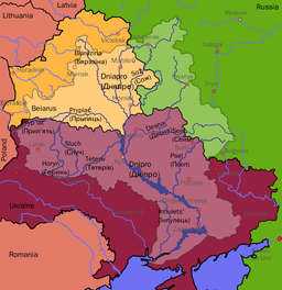 | |
|---|---|---|
| Reservoirs |
| |
| Hydroelectric stations | ||
| Canals |
| |
| Cities | ||
1 Italics indicate left tributaries | ||
Coordinates: 51°56′50″N 30°48′24″E / 51.94722°N 30.80667°E