Sowerby, North Yorkshire
| Sowerby | |
 Front Street Sowerby |
|
 Sowerby |
|
| Population | 4,249 (2011)[1] |
|---|---|
| OS grid reference | SE431810 |
| Civil parish | Sowerby |
| District | Hambleton |
| Shire county | North Yorkshire |
| Region | Yorkshire and the Humber |
| Country | England |
| Sovereign state | United Kingdom |
| Post town | THIRSK |
| Postcode district | YO7 1 |
| Dialling code | 01845 |
| Police | North Yorkshire |
| Fire | North Yorkshire |
| Ambulance | Yorkshire |
| EU Parliament | Yorkshire and the Humber |
| UK Parliament | Thirsk and Malton (formerly Vale of York) |
| Website | http://www.sowerby.org.uk/ |
Coordinates: 54°13′25″N 1°20′21″W / 54.223518°N 1.33926°W
Sowerby is a small village, electoral ward and civil parish in the Hambleton district of North Yorkshire, England, it is situated immediately south of Thirsk. The parish boundary merges with that of Thirsk, so the village could be described as a suburb. The author James Herriot lived in the village.
History
The lines of a Roman road can still be seen in the fields to the north and east of the village along the Green Lane and was known as The Saxty Way.[2][3]
The village is mentioned twice in the Domesday Book as Sorebi in the Yarlestre hundred. The land was split across both the head manors of Easingwold and Newsham. At the time of the Norman invasion, the manors were split between Earl Morcar and Ligulf, who granted land to Orm. Afterwards, the lands became Crown property.[4] The overlordship was granted to the Mowbray family, who granted land to William Lascelles in 1228. The Lascelles family held their manor until 1602, when it was sold to the Meynell family. The manor has followed the inheritance of the manor at North Kilvington since then. William de Vescy of Kildare held a mesne lordship in the area in the 14th century.[2][3]

The Lascelles (Lassels) family were also credited with building a terrace of houses at the north end of the village, still known as Blue (or Bribery) Terrace, since tenants were expected to vote for the candidate who supported the Tory cause.
Sowerby's name comes from the Norse language, in which it means 'Farmstead (by the) muddy/sour ground', which is the origin of the word sewer.[5]
In the south of the parish, Cod Beck is crossed by a 17th-century pack horse bridge at Blakey Lane, which is a Grade II listed building.[6] Further south, Cod Beck is crossed again on South Moor Lane, by another 17th century pack horse bridge, which is also a Grade II Listed building.[7]
An artificial mound known as Pudding Pie Hill[8] is located on the east bank of Cod Beck, just off Blakey Lane. This was partially excavated in 1855 (by Lady Frankland Russell) and was found to be a sepulchral tumulus of a type known as a bowl barrow. The remains of a Saxon warrior and two other skeletons were discovered, along with cremated bones, various artefacts and coins.[2][3]
There are five war memorials in Sowerby, one outside St Oswald's Church and two each inside St Oswald's Church and Sowerby Methodist Church, listing 63 local men who died in the First World War and 18 who died in the Second World War.[9]
Governance
The village lies within the Thirsk and Malton UK Parliament constituency. It also lies within the Sowerby electoral division of North Yorkshire County Council and the Sowerby ward of Hambleton District Council.[10]
Geography
The boundary of the civil parish runs from the A168/A19 junction north to the Moor Lane Stell. From here it runs west, crossing Cod Beck and down Chapel Lane to then follow the A61 as far as Millbank Court. Here it runs south of the housing to cross the East Coast Main Line and then runs south to the boundary of Topcliffe airfield. It then runs east to include most of the small hamlet of Thorpefield and on to Ox Moor plantation. The boundary then follows the southerly route of the Cod Beck as far as, but not including, the hamlet of Westholme. It returns northwards to encompass Sowerby Parks to the A19 at Mile House and then to the A168/A19 junction. Paradise Beck lies wholly within the parish and joins Cod Beck near Sowerby Parks Farm.[10]
The centre of the village has an avenue of English lime trees on Front Street, planted to celebrate the jubilee of Queen Victoria in 1887.[2] To the east of the village is a publicly owned open pasture known as the Sowerby Flatts. The fields show rig and furrow cultivation marks (i.e. dug with a spade rather than a plough) and the river shows signs of the abandoned project (started c. 1768) to build a canal from the centre of the town to connect with the River Swale.[3]
Demography
The 1881 UK Census recorded the population as 1,743.[2] The 2001 UK Census recorded the population as 3,699 in 1,529 households. Of the total population, 48.3% were male and 51.7% were female with 2,851 being more than sixteen years old. There were 1,585 dwellings of which 493 were detached.[11] The 2011 UK Census recorded the population as 4,429 in 1,808 households.[12]
Amenities
Education
The primary schools in the village are Sowerby Community Primary School and All Saints Roman Catholic Primary School.[13][14] A School was originally built as a National School in 1872 on Front Street, but is now private property.[2]
Thirsk School and Sixth Form College, the secondary school for the surrounding area is located in Sowerby and has around 1,200 pupils. Its catchment area covers Alanbrooke, All Saints RC, Baldersby St James CE, Carlton Miniott, Dishforth CE, Pickhill CE, Sessay CE, South Kilvington CE, Sowerby, Thirsk, Topcliffe CE Primary Schools and including some areas served by Knayton CE Primary School.[15]
Economy
The area's main industry is farming, though most people commute to nearby towns and villages. It is also a part of the local tourist activities, with holiday cottages, bed and breakfast providers and a touring caravan site just to the south of the village.
Amenities include a pub/restaurant, The Crown and Anchor, which is Grade II Listed building,.[16] There are also many small and medium-sized businesses.[17]
Also within the parish bounds is the volunteer-run Ritz Cinema in Westgate. It was opened as a picture house in 1912 by Walter Power after converting the original 19th-century Mechanical Institute. After closing in the early 1970s, it was re-opened in 1983. There was another brief closure between 1994 and 1995. It has a seating capacity of 215.[18]
Religion
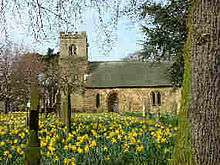
The parish church of St Oswald dates from about 1140. In 1145, Roger de Mowbray, nephew of William the Conqueror, gave the care of the chapel at Sowerby to the Prior of Newburgh, and historical records show that several members of the Lascelles family are buried here. The structure was rebuilt in 1842 and 1883 to accommodate a growing population. The church is a Grade II* listed building.[2][3][19][20]
A Wesleyan Methodist chapel was built on Front Street in 1865, with a school added in 1871.[2]
Notable residents
- The educationalist, John Rowntree, father of York-based cocoa and chocolate manufacturer Joseph Rowntree, was educated at a Quaker school in the village.[21]
- British Member of Parliament, trade union activist and Labour Party vice-chairman Joan Maynard lived and died here.[22]
- The author James Herriot (pen name of Alf Wight) lived at a house in Topcliffe Road.[23]
- Ralph Bell (died 1733), MP for Thirsk 1710–17[24]
References
- ↑ "Parish/Ward population 2011".
- 1 2 3 4 5 6 7 8 Bulmer's Topography, History and Directory (Private and Commercial) of North Yorkshire 1890. S&N Publishing. 1890. pp. 796–798. ISBN 1-86150-299-0.
- 1 2 3 4 5 Page, William, ed. (1923). "Parishes: Thirsk". Victoria County History: A History of the County of York North Riding: Volume 2. Institute of Historical Research. Retrieved 14 February 2013.
- ↑ Sowerby in the Domesday Book. Retrieved 27 January 2013.
- ↑ "Topynomy". Retrieved 27 January 2013.
- ↑ "Blakey Bridge". Retrieved 27 January 2013.
- ↑ "Town end Bridge". Retrieved 27 January 2013.
- ↑ "National Heritage List for England". English Heritage. Retrieved 23 September 2013.
- ↑ "War Memorials in Sowerby". Retrieved 15 November 2014.
- 1 2 Ordnance Survey Open Viewer
- ↑ "2001 UK Census". Retrieved 27 January 2013.
- ↑ "2011 UK Census". Retrieved 15 November 2014.
- ↑ "Community Primary School". Retrieved 27 January 2013.
- ↑ "RC School". Retrieved 27 January 2013.
- ↑ "Secondary Education". Retrieved 27 January 2013.
- ↑ "Crown & Anchor listing". Retrieved 27 January 2013.
- ↑ "Businesses". Retrieved 27 January 2013.
- ↑ "Cinema History". Retrieved 27 January 2013.
- ↑ "Church listing". Retrieved 27 January 2013.
- ↑ "Church History". Retrieved 27 January 2013.
- ↑ "Rowntree". Retrieved 27 January 2013.
- ↑ "Maynard". Retrieved 27 January 2013.
- ↑ "Herriot". Retrieved 27 January 2013.
- ↑ Sedgwick, Romney R. (1970). R. Sedgwick, ed. "BELL, Ralph (d.1733), of Sowerby, Thirsk, Yorks". The History of Parliament: the House of Commons 1715–1754. Boydell and Brewer. Retrieved 30 June 2014.
External links
| Wikimedia Commons has media related to Sowerby, North Yorkshire. |