Southern Germany
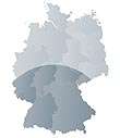
Southern Germany (German: Süddeutschland) as a region has no exact boundary, but is generally taken to include the areas where Upper German dialects are spoken. This corresponds roughly to the historical stem duchies of Bavaria and Swabia, or in a modern context to the states of Bavaria and Baden-Württemberg within the Federal Republic of Germany (to the exclusion of the areas of the modern states of Austria and Switzerland). Sometimes also included are the Saarland and the southern parts of Hesse and Rhineland-Palatinate often are included as well, corresponding to historical Franconia.
Boundaries
Southern Germany primarily contrasts with Northern Germany. The term mostly corresponds to those territories of modern Germany which did not form part of the North German Confederation in the nineteenth century.
Between Northern and Southern Germany is the loosely defined area known as Central Germany (Mitteldeutschland), roughly corresponding to the areal of Central German dialects (Franconia, Thuringia, Saxony).
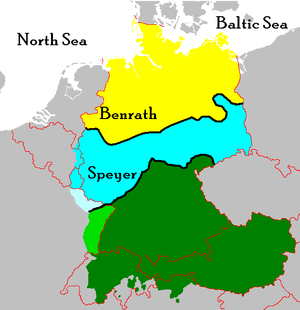
The boundary between the spheres of political influence of Prussia (Northern Germany) and Austria (Southern Germany) within the German Confederation (1815–1866) was known as the "Main line" (Mainlinie, after the River Main), Frankfurt am Main being the seat of the federal assembly. The "Main line" did not follow the course of the River Main upstream of Frankfurt, however, it corresponded rather, to the northern border of the Kingdom of Bavaria.
Linguistically, Southern Germany corresponds to the Upper German dialects. Southern Germany is culturally and linguistically more similar to German-speaking Switzerland, Austria, and German-speaking South Tyrol than to Central and Northern Germany. A jocular term referring to a cultural boundary defining Bavarian culture is Weißwurstäquator, i.e. the "equator" dividing Northern Germany from the homeland of the Weißwurst sausage.
Geography
The River Main, flowing westward, through Upper and Lower Franconia and Southern Hesse, through the city of Frankfurt, into the River Rhine at Mainz, often is cited as a natural border between Southern and Middle Germany while the border west of Mainz is in that respect less clearly determined. The border between the Palatinate and the Rhineland—roughly a line between Bonn and Bingen, in the mountain ranges (Mittelgebirge) of the Westerwald, the Taunus, and the Eifel, along the Rhine and Mosel rivers—is seen as the cultural border between Southern and Western Germany.
Population
Two of the most populous states of Germany, Baden-Württemberg and Bavaria, are part of Southern Germany. They have a combined population of 23,5 million people. In the broader sense (with Rhineland-Palatinate and the Saarland), Southern Germany includes roughly 30 million people. Thus, about 40% of the German population and almost 30% of all native speakers of the German language live there.
The region has a Catholic majority, but also a significant Lutheran Protestant population (especially in Northern Württemberg and some parts of Baden and Franconia (Northern Bavaria)), in contrast to the almost entirely Protestant Northern Germany. Due to the immigration of non-Christians, mainly Turks (see Turks in Germany) during the last decades of the twentieth century, there is also a small number (roughly 250.000, i.e. 2-3% of the population) of Muslims.
Major cities
Where a city has different names in English and German, the English name is given first.
| State capital |
| Rank | City | Pop. 1950 |
Pop. 1960 |
Pop. 1970 |
Pop. 1980 |
Pop. 1990 |
Pop. 2000 |
Pop. 2010 |
Area [km²] |
Density per km² |
Growth [%] (2000– 2010) |
surpassed 100,000 |
State (Bundesland) |
|---|---|---|---|---|---|---|---|---|---|---|---|---|---|
| 1. | | 831,937 | 1,101,384 | 1,311,978 | 1,298,941 | 1,229,026 | 1,210,223 | 1,353,186 | 310,69 | 4,355 | 11.81 | 1852 | |
| 2. | | 532,037 | 675,009 | 666,179 | 629,375 | 644,865 | 648,550 | 679,664 | 248,31 | 2,737 | 4.80 | 1875 | |
| 3. | | 496,490 | 637,366 | 634,202 | 580,648 | 579,988 | 583,874 | 606,588 | 207,35 | 2,925 | 3.89 | 1874 | |
| 4. | | 362,459 | 458,401 | 478,181 | 484,405 | 493,692 | 488,400 | 505,664 | 186,38 | 2,713 | 3.53 | 1881 | |
| 5. | | 245,634 | 311,383 | 332,378 | 304,303 | 310,411 | 306,729 | 313,174 | 144,96 | 2,160 | 2.10 | 1897 | |
| 6. | | 198,840 | 240,450 | 259,091 | 271,892 | 275,061 | 278,558 | 294,761 | 173,46 | 1,699 | 5.82 | 1901 | |
| 7. | | 220,741 | 257,293 | 250,715 | 274,464 | 260,301 | 270,109 | 275,976 | 203,93 | 1,353 | 2.17 | 1905 | |
| 8. | | 185,183 | 206,422 | 213,230 | 248,346 | 256,877 | 254,982 | 264,708 | 146,84 | 1,803 | 3.81 | 1909 | |
| 9. | | 109,717 | 141,637 | 163,568 | 175,106 | 191,029 | 205,102 | 224,191 | 153,06 | 1,465 | 9.31 | 1934 | |
| 10. | | 88,369 | 133,089 | 174,858 | 187,392 | 179,486 | 182,870 | 199,237 | 97,74 | 2,038 | 8.95 | 1908 | |
| Rank | City | Pop. 1950 |
Pop. 1960 |
Pop. 1970 |
Pop. 1980 |
Pop. 1990 |
Pop. 2000 |
Pop. 2010 |
Area [km²] |
Density per km² |
Growth [%] (2000– 2010) |
surpassed 100,000 |
State (Land) |
Characteristics
Economically, Southern Germany is the strongest part of Germany, with Baden-Württemberg and Bavaria the powerhouses of manufacturing, especially in the automobile and machinery industry. Furthermore, it is home to some of the country's most prestigious universities (such as the ones in Heidelberg, Munich, Tübingen, and Würzburg).
The specific features of the landscape are rolling hills, Mittelgebirge (mid-range mountains). Southern Germany also has a part of the Alps, in the southeast of the region (Allgäu and Bavarian Alps). In the culinary field, both beer and wine are produced in lots of varieties almost everywhere in the region. The regional cuisine consists of stews, sausages, cabbage, noodles, and other pasta dishes as well as a variety of holiday cookies, cakes, and tarts.
See also
- Northern Germany
- Central Germany (geography), Central Germany (cultural area)
- Western Germany, Eastern Germany
- Weißwurstäquator
- Upper German
- Alemannic dialects
- Austro-Bavarian dialects
- Franconian dialect
References
- Handbook for Travellers in Southern Germany: Being a Guide to Wuertemberg, Bavaria, Austria, Tyrol, Salzburg, Styria, &c., the Austrian and Bavarian Alps, and the Danube from Ulm to the Black Sea, Murray's foreign handbooks, 1871
Coordinates: 49°N 10°E / 49°N 10°E