Southern General Cemetery
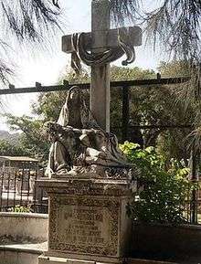 View of the cemetery | |
| Location |
Municipality Libertador |
|---|---|
| Type | Cemetery |
| Opening date | 1876 |
The Southern General Cemetery[1] is the largest cemetery in Caracas. It was founded in 1876, by order of the then President Antonio Guzmán Blanco. It is located at the end of the main avenue of El Cementerio and El Degredo street, in the parish of Santa Rosalia, west of Libertador Municipality, in the Caracas metropolitan area or metropolitan District of Caracas.
In its vicinity is a notable shopping area, especially small retailers and persons engaged in informal trade. It is also near the areas of El Cementerio, Los Castaños, and neighbourhoods like El 1 de mayo, Los Alpes, El León y Santa Elena.
The administration of the cemetery is the responsibility of the Municipal Cemeteries management department, which is attached to Fundacaracas, a foundation of the Libertador Municipality's government.[2] It has the support of Fundapatrimonio, the municipal police in Caracas and the Institute of Cultural Heritage.
Among the well known Venezuelan persons buried there are: Armando Reverón, Raimundo Andueza Palacio, Juan Pablo Rojas Paúl, Miguel Otero Silva, Carlos Delgado Chalbaud, Andrés Mata, Martín Tovar y Tovar, Juan Antonio Pérez Bonalde, Rómulo Gallegos, Argimiro Gabaldón, Fabricio Ojeda, Aquiles Nazoa, Andrés Eloy Blanco, Jorge Rodríguez, Anacleto Clemente Bolívar, Látigo Chávez, General Ramón Centeno and Victorino Ponce, among many others. Some have special memorials such as the Caldera Family, The Firefighters' Pantheon, the President's Pantheon Isaías Medina Angarita or Joaquín Crespo's Mausoleum, this last one built in 1898.[3]
See also
References
- ↑ Correo del Orinoco. "En el Cementerio General del Sur hay muertos que tienen decenas de devotos" (in Spanish). Retrieved 2013-09-08.
- ↑ "Fundacaracas: Cementerio General del Sur" (in Spanish). Retrieved 2013-09-08.
- ↑ "Activan rutas patrimoniales en el Cementerio General del Sur" (in Spanish). Retrieved 2013-09-28.
External links
Coordinates: 10°28′44″N 66°55′16″W / 10.479°N 66.921°W