South Old Bridge, New Jersey
| South Old Bridge, New Jersey | |
|---|---|
| Unincorporated community | |
|
Along CR 516 | |
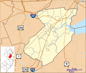 South Old Bridge, New Jersey  South Old Bridge, New Jersey  South Old Bridge, New Jersey Location of South Old Bridge in Middlesex County Inset: Location of county within the state of New Jersey | |
| Coordinates: 40°24′29″N 74°21′16″W / 40.40806°N 74.35444°WCoordinates: 40°24′29″N 74°21′16″W / 40.40806°N 74.35444°W | |
| Country |
|
| State |
|
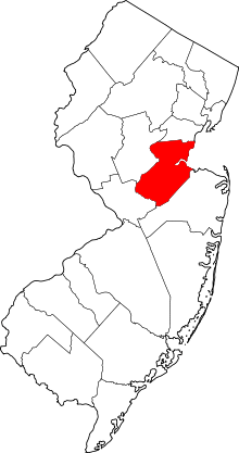
| County | Middlesex |
| Township | Old Bridge |
| Elevation[1] | 23 ft (7 m) |
| GNIS feature ID | 880740[1] |

South Old Bridge is an unincorporated community located within Old Bridge Township in Middlesex County, New Jersey, United States. The community consists of homes and businesses between New Jersey Route 18 and County Route 516 in the western portion of the township.[2] The reason for the odd directional naming is because it is located south of the settlement of Old Bridge (near East Spotswood) while the name of the township of the time was Madison Township.[3]
References
- 1 2 "South Old Bridge". Geographic Names Information System. United States Geological Survey.
- ↑ Google (February 15, 2015). "40.4081628,-74.3543153" (Map). Google Maps. Google. Retrieved February 15, 2015.
- ↑ South Amboy NJ-NY (Map). 1:24000. United States Geological Survey. 1995. Retrieved August 15, 2015.
This article is issued from Wikipedia - version of the 6/10/2016. The text is available under the Creative Commons Attribution/Share Alike but additional terms may apply for the media files.