South Belridge Oil Field

The South Belridge Oil Field is a large oil field in northwestern Kern County, San Joaquin Valley, California, about forty miles west of Bakersfield. Discovered in 1911, and having a cumulative production of over 1.5 billion barrels of oil at the end of 2008, it is the fourth-largest oil field in California, after the Midway-Sunset Oil Field, Kern River Oil Field, and Wilmington Oil Field, and is the sixth-most productive field in the United States. Its estimated remaining reserves, as of the end of 2008, were around 494 million barrels, the second-largest in the state, and it had 6,253 active wells.[1] The principal operator on the field was Aera Energy LLC, a joint venture between Royal Dutch Shell and ExxonMobil. Additionally, the field included the only onshore wells in California owned and operated by ExxonMobil.[2]
Setting
The oil field is located along State Route 33, between the junctions with State Route 58 on the south and State Route 46 on the north. The field is in an area of gentle slope to the southwest, just above the San Joaquin Valley which is adjacent on the east; the crest of the Temblor Range, the nearest part of the California Coast Ranges, parallels the oil field about ten miles to the southwest. The field is about ten miles long by two wide, and encompasses 9,420 productive acres. Elevations on the oil field range from approximately 450 to 700 feet; the elevation of the floor of the San Joaquin Valley to the east is around 250 feet.
The South Belridge Oil Field is part of the larger Belridge Producing Complex of Aera Energy LLC, which includes also the smaller, but still substantial oil fields of North Belridge, Lost Hills, and Cymric, all in northwestern Kern County.
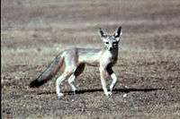
Most native vegetation is gone from the oil field, with the most dense operational areas being almost completely barren except for pumping units, drilling pads, evaporation ponds, storage tanks, steam generators, and associated equipment. In spite of this seeming sterility, species such as the endangered San Joaquin kit fox (vulpes macrotis mutica) continue to use areas of oil field development as habitat.[3]
Geology
The South Belridge Field is a southeast-plunging anticline, in which the oil has collected in pools in structural traps sealed by both above-lying impermeable units as well as tar seals. Most of the oil has pooled in the Tulare Formation, of Pleistocene age, and in the Diatomite Formation, of Pliocene−Miocene age. The oil itself probably originated in the underlying Monterey Formation, migrating upward to structural and stratigraphic traps over time.[4]
Extraction
A total of six oil pools have been found in the South Belridge: the Tulare, Etchegoin, Diatomite, Antelope Shale, McDonald, and Devilwater-Gould. Both the Tulare and Diatomite were discovered in 1911, and these are both the largest and nearest the surface, with average depths of 400 and 1,000 feet respectively. The Antelope Shale, at 4,000 feet, and the McDonald, at 6,700, are the deepest working pools, and are both in the Monterey Formation itself. The Devilwater-Gould, found in 1980 at a depth of 8,200 feet, only produced from one well for nine months, and was abandoned.[5]
Only two of the pools contained significant enough reserves to be subject to enhanced recovery projects: the Tulare and Diatomite, both of which have been steamflooded, waterflooded, and fireflooded. Operators began steamflooding the Tulare Formation in 1963 in order to increase production rates; as of 1997, this was the only enhanced recovery technology still in use there. Oil from the Tulare Formation is heavy crude, with a specific gravity of 10–13 API, and a low sulfur content of 0.23%, while oil from the Diatomite is classified as medium crude, with an API index of 25–30.[6]
Operations
Belridge Oil Company discovered the field. It retained control of operations until 1979 when Shell Oil purchased the company along with most of the production rights on the South Belridge Field for $3.65 billion. Currently Aera Energy LLC is the main operator on the field. They claim a daily production of 140,000 barrels of oil equivalent (boe/d) from the entire Belridge Unit, with the oil being shipped to the refineries in Martinez and Torrance for processing into gasoline and other products.[7][8]

As of the end of 2006 Aera Energy was the second-largest producer of oil in California, after Chevron Corp.[9]
References
- California Oil and Gas Fields, Volumes I, II and III. Vol. I (1998), Vol. II (1992), Vol. III (1982). California Department of Conservation, Division of Oil, Gas, and Geothermal Resources (DOGGR). 1,472 pp. South Belridge field information is on pp. 36–38. PDF file available on CD from www.consrv.ca.gov.
- California Department of Conservation, Oil and Gas Statistics, Annual Report, December 31, 2006.
Notes
- ↑ "2008 Report of the state oil & gas supervisor" (PDF). Department of Oil, Gas, and Geothermal Resources. California Department of Conservation ("DOGGR 2009"). 2009. Retrieved October 29, 2011. p. 63.
- ↑ DOGGR (2009), 127
- ↑ David Whyte MacDonald, Claudio Sillero-Zubiri: The Biology and Conservation of Wild Canids. Oxford University Press, 2004. p. 194. ISBN 0-19-851555-3
- ↑ South Belridge fields, Borderland basin, U.S., San Joaquin Valley
- ↑ DOGGR, California Oil and Gas Fields, pp. 36–38
- ↑ DOGGR, California Oil and Gas Fields, p. 37
- ↑ Article on South Belridge in the Bakersfield Californian, April 27, 1999
- ↑ Aera Energy LLC; page on the Belridge operations.
- ↑ DOGGR (2009), 64
External links
- 100 Years of Oil, from the Bakersfield Californian: stories about local oilfields including the South Belridge
- Approximate center of the field, in Google Maps
Coordinates: 35°27′22″N 119°43′29″W / 35.4560°N 119.7246°W