Solway Plain
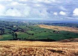
The Solway Plain[1] or Solway Basin is a coastal plain in the northwest of Cumbria, England and stretching over the Scottish border to the low-lying area around Gretna and Annan [2] It is an area generally lying north and west of Carlisle along the Solway Firth and drained by the rivers Esk and Lyne. This geographic unit is associated with the westernmost part of Hadrian's Wall.[3] In medieval times clay houses known as dabbins were commonly built on the Solway Plain.[4] The Solway Coast is designated as an Area of Outstanding Natural Beauty.[5]
The area has a recognised archaeological heritage. Sites mentioned in Hodgson and Brennand[6] include a possible domestic settlement at Plasketlands, urned cremation cemeteries at Ewanrigg, and a potential pre-Roman phase of occupation at several sites, including Ewanrigg, Wolsty Hall and Boustead Hill. The Moss at Salta has been a Site of Special Scientific Interest since 1954. It has unusual flora for a mire on the Solway Plain, and was also the site where a Bronze Age rapier was discovered.[7]
Proposed nuclear waste facility
In June 2012, it became clear that the Solway Plain between Silloth, Abbeytown and Westnewton has been identified as a potential site for a Geological Disposal Facility for the UK's high level nuclear waste. Two other sites have also been identified - Eskdale and the Ennerdale. The Solway Plain wasn't named by the Managing Radioactive Waste Safely (MRWS) Partnership, rather they referred to the 'Low permeability sedimentary rocks associated with the Mercia Mudstone Group(MMG)'. This was in (publicly available) document 285 of the West Cumbria MRWS in a report written by Dr Dearlove, the consultant geologist recruited by MRWS.
See also
References
- ↑ Solway Plain National Character Area
- ↑ A. J. Scott (2015) "Solway Country: Land, Life and Livelihood in the Western Border Region of England and Scotland," Newcastle: Cambridge Scholars Publishing
- ↑ Hadrian's Wall NMP - Solway Plain, English Heritage
- ↑ Nina Jennings, The Building of the Clay Dabbins of the Solway Plain: Materials and Man-Hours, Vernacular Architecture 33 (2002), 19-27
- ↑ Solway Coast AONB
- ↑ North West Region Archaeological Research Framework Prehistoric Resource Assessment
- ↑ "Natural England - Solway Moss SSSI" (PDF). Retrieved 21 December 2014.