Solar compass

The solar compass, a surveying instrument that makes use of the sun's direction, was first invented and made by William Austin Burt.[1] He patented it on February 25, 1836, in the United States Patent Office as No 9428X.[2] It received a medal at the Great Exhibition of 1851.[3]
History
From the middle of the 19th century until late in the 20th century, the solar compass was widely employed for surveying land. Its original impetus was for use where magnetic compasses were susceptible to iron bearing minerals that made for inaccurate readings. It was then found to be superior to the magnetic compass even when local attraction was not a problem. Its close relative, a solar compass attachment to a surveyor's transit, was still a recommended method of obtaining direction in the 1973 manual of the US Bureau of Land Management.[4] Using the location of the sun, or occasionally the moon, with astronomical tables, the solar compass enabled surveyors to run more accurate lines, saving its user valuable time.
Burt, a United States Deputy Surveyor, began surveying government lands in Michigan in 1833. While working in Wisconsin, where there were large deposits of iron ore, Burt experienced great difficulty in using his standard vernier scale compass. This motivated him to find a solution that was not dependent on magnetism and would not be influenced by earth's ore materials. With his mechanical abilities, he then devised and built the solar compass. Burt made a model of his instrument in 1835 to test its validity. The instrument was then submitted to a committee at the Franklin Institute in Philadelphia. They examined its principles and merits and ultimately awarded Burt twenty dollars in gold and the John Legacy Medal.[5] He improved on his surveying instrument and in 1840 re-submitted it to the Franklin Institute. The instrument was further improved over the years and in 1851 he exhibited that version at the Great Exhibition in London, where he was awarded another prize medal.[5] He then received another medal by jurors of Astronomical Instruments.[6]
When Burt's solar compass original patent of 1836 was about to expire, he went to Washington to apply for a renewal in 1850. The land commissioner committee, who consisted of senators from Michigan and other states, recognizing the value of Burt's solar compass in public land surveys, persuaded him to forego renewal and petition congress for suitable advance compensation. Burt did as was suggested to him on the faith he would get paid for his patent of such a valuable instrument. However the compensation indicated did not materialize in Burt's lifetime or at any time thereafter. Since there was no patent on Burt's solar compass after 1850, instrument makers sold "Burt's solar compass" to surveyors.[7]
In the preface to his Key to the Solar Compass and Surveyor's Companion published in 1858 by his associate William S. Young, Burt refers to the many requests for such a book on how to use his solar compass. He explains a magnetic compass had problems with the true meridian at different localities. It also had problems from day to day with different readings from that expected as a constant or from previous readings. It was determined that a magnetic compass used as a surveying tool was interfered many times from the local attraction of iron ore. A much better guide for the surveyor than the magnetic needle compass was much needed. Burt’s diligent hard work, persistence and perseverance ultimately paid off in the invention of the Solar or Astronomical Compass.[6]
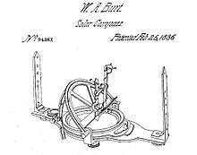
Description
Burt’s solar compass is a precision instrument made of brass with a solar attachment that allows surveyors to determine the true north direction by reference to the sun rather than by reference to the magnetic north pole.[5] It allowed surveyors to locate true north through viewing the sun and other astronomical observations and was not influenced by magnetism or iron ore or other ore materials.[3] The United States government required land surveys to be done by Burt's Solar compass; as in many cases the cost to accurately survey lands with heavy mineral deposits that interfered with normal instrumentation would have exceeded the value of the land.[3]
Burt’s precision surveying instrument consists of three arcs: one for setting the latitude of the land; one for setting the declination of the sun; and one for setting the hour of the day. The instrument has two main plates, the upper and the lower. On the lower plate is placed the sights. This plate revolves underneath the upper plate on a centre. The upper plate remains stationary. The lower plate may be clamped in any position to the upper plate.[8][9]
There is a graduated ring on the lower plate which covered by the upper plate, except two openings at opposite points. Here there are verniers to read angles. On the upper plate is placed a needle box, having divisions for the north end the needle only of about 36 degrees, with a vernier to read the needle's variation. Upon this plate, is placed the solar apparatus. It consists of a latitude arc, declination arc, and an hour arc. There are also two levels, placed right angles with each other, together with other necessary fixtures.[8][9]
The latitude arc is that which is attached by screws to the plate. It stands nearly vertical to the plate. The hour arc lies partly horizontal over the levels, and the declination arc placed upon a revolving limb, above the plate, and other fixtures of the solar apparatus. On this revolving limb is placed another movable limb, which turns on a joint at one end, and the other end, with a vernier, moves over the declination arc, with a clamp screw, to clamp it to the sun's declination for the time being. At each end of this described limb, there is attached to it a small brass plate standing out at right angles with the limb, and into the upper side of one and the lower side of the other, is set a small convex lens. Opposite to each lens on the brass plates there is attached a small silver plate, by means of three small screws and on each of these, lines are drawn at a suitable distance apart to embrace the sun's image, which falls upon each from the lenses. It will be seen, by inspecting this part of the instrument, that it must be used one end towards the sun, when he has north declination, and the other end for south declination.[8][9]
To gain a better understanding of the set of parts of the solar apparatus just described one should pay particular attention to the apparent motion of the sun or stars, around the earth, regarding the earth as lies center of their daily revolutions. A distinct view of the apparent conical motion of the sun, when it has north or south declination, is necessary, in order to understand how the movable parts of the solar apparatus may be adjusted to trace the sun, in its apparent course, while the sights of the sun compass remains stationary. If one imagined he was at the Earth's equator and the sun had no declination, the sun would rise to him due east, and set due west. At noon the sun would be at the highest point, and in the lowest point at midnight. In other words, when the sun has no declination, its apparent revolutions are in a perfect plane with the Earth's equator.[8][9]
If a straight line were drawn from the rising sun to the setting sun, and from the sun at noon and at midnight, both of these lines would pass through the Earth's center and the equator would intersect these lines. This is not so when the sun has north or south declination because its apparent motion will have an angle to the above described plane or lines, with the Earth's center, equal to the amount of the sun's declination north or south. Then it will be seen, that when the sun has north or south declination, and the earth is regarded as the center of its revolutions the plane just mentioned becomes conical.[8][9]
This apparent conical motion of the sun may be further explained by the spoked wheels of a covered wagon. The rim representing the sun's apparent path, the hub, the earth, and the spokes, lines drawn from the sun's path. Then it may be seen that a line drawn from the sun to the Earth's center would pass north or south of the equator, equal in degree to its declination north or south. These apply to the apparent revolutions of the planets and fixed stars as well.[8][9]
The operation is as follows:
- Set the sun's declination for that day, obtained by means of tables, on a scale attached perpendicular to the time dial.
- Set the latitude on a scale in the alidade.
- Set the approximate local time on a dial that rotates on a polar axis.
- Orient the instrument, while remaining level, so the image of the sun appears between scribed lines on a screen below a lens. The time dial is fine adjusted to bring the image between lines perpendicular to the first set. The time axis will then point to the pole.
- The pinnula (sighting vanes) may then be pointed to a terrestrial object and its bearing read from the angle scale.
- The magnetic declination may be read from a compass attached to the base plate.[8][9]
Sun compass
A much simpler sun compass, developed by Lt-Col. James Allason, a mechanised cavalry officer, was adopted by the British Army in India in 1938, following distortion in the magnetic field experienced when the standard issue prismatic compass was used in or near tanks and other armored vehicles. Cloudy European skies prevented its adoption in European theaters during World War II although it became standard for the Long Range Desert Group operating in the North African desert. A manual is preserved in the archive of the Imperial War Museum.[10]
See also
- Astrocompass
- Grid compass
- Pfund sky compass
- Icelandic solarstein, used by medieval Vikings
- Vegvísir
References
- ↑ Mining and metallurgy, Issues 169-180 By American Institute of Mining and Metallurgical Engineers, p. cccxli Charles S. Burt, the grandson of William Austin Burt
- ↑ Solar Compass
- 1 2 3 Farmer, p. 362
- ↑ http://www.blm.gov/cadastral/Manual/73man/id34.htm
- 1 2 3 White, p. 367
- 1 2 Burt, Key to the Solar Compass and Surveyor's Companion preface
- ↑ Fuller, pp. 175-193 William Austin Burt- inventor, by Horace Eldon Burt (Chicago) biography
- 1 2 3 4 5 6 7 Description of the Solar Compass , pp. 3-19
- 1 2 3 4 5 6 7 A Key to the Solar Compass, and Surveyor’s Companion, pp. 9-11
- ↑ Ringside Seat, by James Allason, Timewell Press, London 2007.
Sources
- Burt, William A. Description of the Solar Compass (Detroit, 1844).
- Burt, William A. A Key to the Solar Compass, and Surveyor’s Companion, third edition, publisher D. van Nostrand, (New York, 1873).
- Burt, John, History of the Solar Compass Invented by Wm. A. Burt (Detroit, 1878).
- Farmer, Silas, The history of Detroit and Michigan, 1899
- Fuller, George Newman, Michigan history, Volume 6, Michigan Department of State, 1922
- Tuttle, Charles Richard, General History of the state of Michigan with biographical sketches, R. D. S. Tyler & Co., Detroit Free Press Company, 1873
- White, James T., Cyclopedia of American Biography, volume xviii, 1922
External links
- Onsrud Manual, Appendix 5 - Solar Compass
- Picture and description of Burt Solar Compass, Wisconsin Historical Society
- Solar Compass patent photo and transcription
- Patent 9428X Solar Compass