Small Isles
Not to be confused with the Small Isles off south east
Jura.
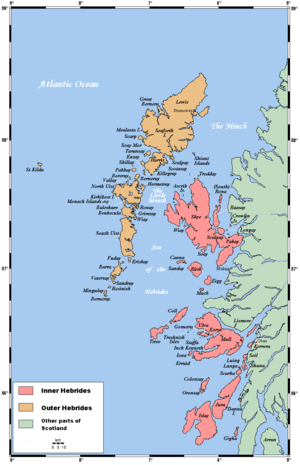
The Small Isles are at the centre of this Hebrides map

Blaeu's 1654 Atlas of Scotland - The Small Isles. Rum is at centre, surrounded by "Kannay', 'Egg' and 'Muck'.

A distant view of Eigg, with the hills of Rùm behind
The Small Isles (Scottish Gaelic: Na h-Eileanan Tarsainn)[1] are a small archipelago of islands in the Inner Hebrides, off the west coast of Scotland. They lie south of Skye and north of Mull and Ardnamurchan – the most westerly point of mainland Scotland. The Small Isles is one of 40 National Scenic Areas in Scotland.[2]
Main islands
The four main islands are Canna, Rùm, Eigg and Muck. The largest is Rùm with an area of 41 square miles (110 km2).
The islands now form part of Lochaber, in the Highland council area. Until 1891 Canna, Rùm and Muck were historically part of the counties of Argyll; Eigg was historically part of Inverness-shire, and all of the Small Isles were in Inverness-shire, from 1891 to 1975. The Gaelic name is literally "cross isles" referring to their position between the Morar and the Uists.[1]
Smaller islands
Smaller islands surrounding the main four include:
Skerries
There are also a number of skerries:
- Hyskeir, (not to be confused with Heisker or the Monach Islands in the Outer Hebrides)
- Garbh Sgeir,
- Eagamol, near Eilean nan Each
- Humla, and
- two places called Dubh Sgeir
Footnotes
External links
|
|---|
|
| |
|
|
|
|
|
|
|
|
|
| Culture |
|---|
| | Shetland | |
|---|
| | Orkney | |
|---|
| | Outer Hebrides | |
|---|
| | Inner Hebrides | |
|---|
|
|
|
| Politics |
|---|
| | Local authorities | |
|---|
| | Serving MSPs | |
|---|
| | Serving MPs | |
|---|
| | Other | |
|---|
|
|
|
| Wildlife |
|---|
| | Fauna | |
|---|
| | Flora | |
|---|
| | Domesticated animals | |
|---|
|
|
|
|
Coordinates: 56°58′N 6°16′W / 56.967°N 6.267°W / 56.967; -6.267
