Skykomish, Washington
| Skykomish, Washington | |
|---|---|
| Town | |
 | |
 Location of Skykomish, Washington | |
| Coordinates: 47°42′36″N 121°21′21″W / 47.71000°N 121.35583°WCoordinates: 47°42′36″N 121°21′21″W / 47.71000°N 121.35583°W | |
| Country | United States |
| State | Washington |
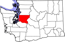
| County | King |
| Area[1] | |
| • Total | 0.33 sq mi (0.85 km2) |
| • Land | 0.31 sq mi (0.80 km2) |
| • Water | 0.02 sq mi (0.05 km2) |
| Elevation | 928 ft (283 m) |
| Population (2010)[2] | |
| • Total | 198 |
| • Estimate (2015)[3] | 207 |
| • Density | 638.7/sq mi (246.6/km2) |
| Time zone | PST (UTC-8) |
| • Summer (DST) | PDT (UTC-7) |
| ZIP code | 98288 |
| Area code(s) | 360 |
| FIPS code | 53-64855 |
| GNIS feature ID | 1525897[4] |
| Website | / Official Website |
Skykomish is a town in King County, Washington, United States. The population was 198 as of the 2010 census, down from an estimated peak of "several thousand" in the 1920s.[5]
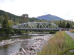
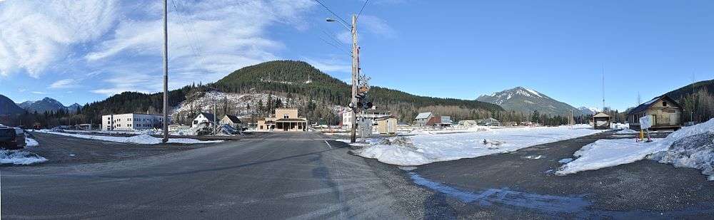
Located in the Mount Baker-Snoqualmie National Forest, near Deception Falls on the Skykomish River, Skykomish was founded as a railroad town. Today, it is mainly a stopping point for recreational access to the surrounding mountains, including skiing at nearby Stevens Pass.
Being located in the far northeastern corner of King County, mountains deny Skykomish any road access to the rest of the county. Instead, U.S. Highway 2 (known in the area as the Cascade Highway) connects it with Snohomish County to the north and through Stevens Pass (17 miles east of town) to Chelan County.
History
The name "Skykomish" derives from the Skykomish or Skai-whamish tribe (originally considered a subdivision of the Snoqualmies) who inhabited the area before European settlement.[6] The town of Skykomish was officially incorporated on June 5, 1909.
From the 1890s to 1974, Skykomish was a maintenance and fueling station for the Great Northern Railway, which eventually became part of the Burlington Northern Railroad, and presently the BNSF Railway. It was also once the western terminus for electric operations (1909–56) on the Cascade Tunnel route all the way to Wenatchee. Here, steam or diesel locomotives were changed or coupled to electric locomotives.[7]
Waste disposal practices, common during that era, resulted in the contamination of its soil, its groundwater, and the Skykomish River by oil and heavy metals. BNSF (then BN) and the Washington State Department of Ecology began remediation discussions in the mid-1980s, and in 2006, agreed to a plan whereby the railroad would pay up to $50 million to clean up the area over a three-year period (completed in 2009). This effort involved massive excavations—essentially removing the contaminated soil and replacing it with clean soil—and the rebuilding of a levee. Many of Skykomish's buildings—both homes and business—were moved during the cleanup process.
Geography
Skykomish is located at 47°42′36″N 121°21′21″W / 47.71000°N 121.35583°W (47.710048, -121.355695).[8]
According to the United States Census Bureau, the town has a total area of 0.33 square miles (0.85 km2), of which, 0.31 square miles (0.80 km2) is land and 0.02 square miles (0.05 km2) is water.[1]
Climate
| Climate data for Skykomish, Washington | |||||||||||||
|---|---|---|---|---|---|---|---|---|---|---|---|---|---|
| Month | Jan | Feb | Mar | Apr | May | Jun | Jul | Aug | Sep | Oct | Nov | Dec | Year |
| Average high °F (°C) | 39.7 (4.3) |
42.4 (5.8) |
49.9 (9.9) |
58.2 (14.6) |
64.9 (18.3) |
69.8 (21) |
76.1 (24.5) |
75.2 (24) |
70.5 (21.4) |
59.0 (15) |
46.8 (8.2) |
40.9 (4.9) |
57.8 (14.3) |
| Average low °F (°C) | 27.2 (−2.7) |
27.5 (−2.5) |
31.4 (−0.3) |
38.0 (3.3) |
43.5 (6.4) |
49.0 (9.4) |
49.0 (9.4) |
49.7 (9.8) |
47.0 (8.3) |
40.8 (4.9) |
32.7 (0.4) |
31.3 (−0.4) |
38.9 (3.8) |
| Average precipitation inches (mm) | 12.60 (320) |
12.26 (311.4) |
9.35 (237.5) |
6.17 (156.7) |
5.25 (133.4) |
3.77 (95.8) |
1.62 (41.1) |
2.14 (54.4) |
3.86 (98) |
8.19 (208) |
11.37 (288.8) |
15.15 (384.8) |
91.73 (2,329.9) |
| Average snowfall inches (cm) | 14.2 (36.1) |
17.7 (45) |
6.8 (17.3) |
0.2 (0.5) |
0 (0) |
0 (0) |
0 (0) |
0 (0) |
0 (0) |
0 (0) |
0 (0) |
7.6 (19.3) |
46.5 (118.2) |
| Source: Western Regional Climate Center[9] | |||||||||||||
Demographics
| Historical population | |||
|---|---|---|---|
| Census | Pop. | %± | |
| 1910 | 238 | — | |
| 1920 | 267 | 12.2% | |
| 1930 | 562 | 110.5% | |
| 1940 | 479 | −14.8% | |
| 1950 | 497 | 3.8% | |
| 1960 | 366 | −26.4% | |
| 1970 | 283 | −22.7% | |
| 1980 | 209 | −26.1% | |
| 1990 | 273 | 30.6% | |
| 2000 | 214 | −21.6% | |
| 2010 | 198 | −7.5% | |
| Est. 2015 | 207 | [10] | 4.5% |
| U.S. Decennial Census[11] 2015 Estimate[3] | |||

2010 census
As of the census[2] of 2010, there were 198 people, 95 households, and 45 families residing in the town. The population density was 638.7 inhabitants per square mile (246.6/km2). There were 168 housing units at an average density of 541.9 per square mile (209.2/km2). The racial makeup of the town was 95.5% White, 1.0% African American, 1.5% Native American, 1.5% Asian, and 0.5% from two or more races. Hispanic or Latino of any race were 1.5% of the population.
There were 95 households of which 20.0% had children under the age of 18 living with them, 34.7% were married couples living together, 4.2% had a female householder with no husband present, 8.4% had a male householder with no wife present, and 52.6% were non-families. 44.2% of all households were made up of individuals and 14.7% had someone living alone who was 65 years of age or older. The average household size was 2.08 and the average family size was 2.87.
The median age in the town was 51.3 years. 18.2% of residents were under the age of 18; 6.1% were between the ages of 18 and 24; 18.7% were from 25 to 44; 38.4% were from 45 to 64; and 18.7% were 65 years of age or older. The gender makeup of the town was 57.1% male and 42.9% female.
2000 census
As of the census of 2000, there were 214 people, 104 households, and 58 families residing in the town. The population density was 623.2 people per square mile (243.0/km²). There were 162 housing units at an average density of 471.8 per square mile (184.0/km²). The racial makeup of the town was 94.39% White, 0.47% African American, 1.40% Native American, 0.93% Asian, and 2.80% from two or more races. Hispanics or Latinos of any race were 2.80% of the population.
There were 104 households, of which 20.2% had children under the age of 18 living with them. 48.1% were married couples living together, 2.9% had a female householder with no husband present, and 44.2% were non-families. 34.6% of all households were made up of individuals and 17.3% had someone living alone who was 65 years of age or older. The average household size was 2.06 and the average family size was 2.66.
18.2% of the town's population was under the age of 18, 5.1% from 18 to 24, 23.8% from 25 to 44, 34.1% from 45 to 64, and 18.7% 65 or older. The median age was 46 years. For every 100 females, there were 96.3 males. For every 100 females age 18 and over, there were 103.5 males.
The median income for a household in the town was $45,357, and the median income for a family was $48,500. Males had a median income of $42,500 versus $25,938 for females. The per capita income for the town was $22,829. About 3.0% of families and 9.0% of the population were below the poverty line, including 8.6% of those under the age of 18 and none of those 65 or over.
References
- 1 2 "US Gazetteer files 2010". United States Census Bureau. Retrieved 2012-12-19.
- 1 2 "American FactFinder". United States Census Bureau. Retrieved 2012-12-19.
- 1 2 "Population Estimates". United States Census Bureau. Retrieved July 12, 2016.
- ↑ "Skykomish". Geographic Names Information System. United States Geological Survey.
- ↑ Stein, Alan J. (August 12, 1999). "Skykomish -- Thumbnail History". Essay 1623. HistoryLink.org. Retrieved 2008-11-07.
- ↑ Ruby, Robert H. and John Arthur Brown. (1992.) A Guide to the Indian Tribes of the Pacific Northwest, 2nd ed. University of Oklahoma Press. p. 211. ISBN 0-8061-2479-2. Google Book Search. Retrieved 2009-12-13.
- ↑ Middleton, William D. When the Steam Railroads Electrified. Indiana University Press: 2002. ISBN 978-0-253-33979-9
- ↑ "US Gazetteer files: 2010, 2000, and 1990". United States Census Bureau. 2011-02-12. Retrieved 2011-04-23.
- ↑ http://www.wrcc.dri.edu/cgi-bin/cliMAIN.pl?wa7708
- ↑ "Annual Estimates of the Resident Population for Incorporated Places: April 1, 2010 to July 1, 2015". Retrieved July 2, 2016.
- ↑ United States Census Bureau. "Census of Population and Housing". Retrieved July 31, 2013.
External links
| Wikimedia Commons has media related to Skykomish, Washington. |
- Official website
- Historylink page on Skykomish
- Skykomish Fire Department
- Skykomish Historical Society
Municipalities and communities of King County, Washington, United States | ||
|---|---|---|
| Cities |
|  |
| Towns | ||
| CDPs |
| |
| Unincorporated communities | ||
| Indian reservation | ||
| Ghost towns | ||
| Footnotes | ‡This populated place also has portions in an adjacent county or counties | |