Skidegate
| Skidegate Hlg̱aagilda | |
|---|---|
| Indian Reserve | |
|
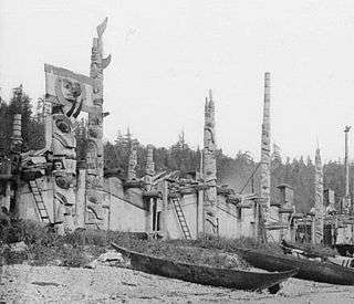
View of the Kay Llnagaay beach in Skidegate. | |
 Location of Skidegate in Haida Gwaii | |
| Coordinates: 53°16′02″N 131°59′26″W / 53.26722°N 131.99056°WCoordinates: 53°16′02″N 131°59′26″W / 53.26722°N 131.99056°W | |
| Country |
|
| Province |
|
| Region | Haida Gwaii |
| Regional district | Skeena-Queen Charlotte |
| Founded | 1850 |
| Government | |
| • Chief Councillor | Willard Wilson |
| Area | |
| • Total | 5.65 km2 (2.18 sq mi) |
| Elevation | 28 m (92 ft) |
| Population (2006)[1] | |
| • Total | 781 |
| • Density | 138.3/km2 (358/sq mi) |
| Time zone | PST (UTC-8) |
| Highways | 16 |
| Waterways | Hecate Strait |

Skidegate /ˈskɪdᵻɡᵻt/ (Haida: Hlg̱aagilda)[2] is a Haida community in Haida Gwaii (formerly the Queen Charlotte Islands) in British Columbia, Canada. It is located on the southeast coast of Graham Island,[3] the largest island in the archipelago, and is approximately 50 kilometres (31 mi) west of mainland British Columbia across Hecate Strait. Skidegate, which is located on Skidegate Indian Reserve No. 1 and was formerly home to the Skidegate Mission[4][5] is also the northern terminal for the BC Ferries service between Graham Island and Alliford Bay on Moresby Island.
Skidegate was so named in the early 19th century, after its chief, according to tradition. The community was a hub for the trade of otter furs.[6]
The Haida Heritage Centre is located in Skidegate along the town's Eastern boundary.
See also
References
- ↑ Statistics Canada. 2006 Census
- ↑ "FirstVoices: Hlg̱aagilda X̱aayda Kil: words". Retrieved 2012-07-08.
- ↑ BC Names/GeoBC entry "Skidegate (community)"
- ↑ BC Names/GeoBC entry "Skidegate Mission (community)"
- ↑ BC Names/GeoBC entry "Skidegate 1 (Indian reserve)"
- ↑ http://www.vancouverisland.com/regions/towns/?townID=3732