Skalica
| Skalica | ||
| Town | ||
 City centre of Skalica | ||
|
||
| Country | Slovakia | |
|---|---|---|
| Region | Trnava | |
| District | Skalica | |
| River | Morava | |
| Elevation | 186 m (610 ft) | |
| Coordinates | SK 48°50′32″N 17°13′36″E / 48.84222°N 17.22667°ECoordinates: SK 48°50′32″N 17°13′36″E / 48.84222°N 17.22667°E | |
| Area | 60.007 km2 (23 sq mi) | |
| Population | 14,963 (31 December 2005) | |
| Density | 249/km2 (645/sq mi) | |
| First mentioned | 1217 | |
| Mayor | Stanislav Chovanec | |
| Timezone | CET (UTC+1) | |
| - summer (DST) | CEST (UTC+2) | |
| Postal code | 909 01 | |
| Phone prefix | 421-34 | |
| Car plate | SI | |
  Location of Skalica in Slovakia | ||
  Location of Skalica in the Trnava Region | ||
| Wikimedia Commons: Skalica | ||
| Statistics: MOŠ/MIS | ||
| Website: http://www.skalica.sk | ||

Skalica (German: Skalitz, Hungarian: Szakolca, Latin: Sakolcium) is the largest city in Skalica District in western Slovakia in the Záhorie region. Located near the Czech border, Skalica has a population of 14,963 (as of 2005).
Etymology
The name is derived from Slovak word skala (a rock) referring to the cliffs the inhabitants built their settlement over.[1] The first written record of Skalica was made in 1217 as Skalza.[1]
History
The site has been inhabited since 4000 BC and was part of the Great Moravian Empire.[2][3] From the second half of the 10th century until 1918, it was part of the Kingdom of Hungary. The settlement developed around a triangular plaza, which was rare during the Middle Ages. Its town privileges were conferred in 1372 by King Louis I of Hungary. In 1428 Skalica became a bastion for the Hussites; during the Hussite Wars, the majority of its then predominantly German-speaking populace fled or was exiled. Many Habaners (adherents of a sect similar to Anabaptism) settled in Skalica in the 16th century.
On 6 November 1918 Skalica became the seat of the Temporary Government of Slovakia, for ten days de facto capital of Slovakia. The Temporary Government led by Vavro Šrobár declared here a sovereignty of the Czechoslovak state, published a newspaper Sloboda (Liberty) and unsuccessfully tried to negotiate the removal of Hungarian troops from Upper Hungary (today Slovakia).
After World War II, the town tried to take advantage of its position as a district town, and many new works, schools and apartments blocks were built, while successfully preserving its historical city centre. In 1960, Skalica became part of Senica district. This lasted until 1996, when Skalica became a separate district again.
Didaktik computers were produced in Skalica during the 1980s. The 2006 European Table Hockey Championships were held in the town.
A popular pastry called Trdelník is made in Skalica. Now sold all over the Slovak and Czech Republics, this unusual "stove-pipe" shaped pastry has its origins in Transylvania.
Today, it is economically the strongest town in the Záhorie region, bypassing its rival town Senica for this position, and is becoming a tourist destination thanks to its preserved city centre and historical monuments.
Sights

Near the remnants of one of Skalica's city walls is one of Slovakia's oldest works of construction, the Romanesque Rotunda of St. George. Although its exact date of origin is unknown, it was constructed by the 12th century at the latest. A Baroque dome was attached to it in the 17th century. The city has several churches, including a Jesuit church and monastery, the 15th century Parish Church of St. Michael, and the 15th century Franciscan church and monastery. Other sights are Skalica's Late Renaissance town hall and the Skalica Culture House built in the Art Nouveau with elements of Czech and Slovak folklore.[4]
Demographics
According to the 2001 census, the town had 15,013 inhabitants. 94.84% of inhabitants were Slovaks, 3.61% Czechs and 0.61% Roma.[5] The religious make-up was 70.15% Roman Catholics, 19.92% people with no religious affiliation and 6.67% Lutherans.[5]
Sports
- HK 36 Skalica, ice hockey club from the town and MFK Skalica, football club in the Slovak Super Liga.
Famous people
- Béla II of Hungary, king[6]
- János Csernoch, primate of Hungary
- Ján Hollý, poet, studied in Skalica
- Gyula Juhász, poet [7]
- Milan Mišík, geologist, university professor
- Žigmund Pálffy, ice hockey player
- Marián Varga, musician
- Miroslav Zálešák, ice hockey player
Partner towns
Gallery
 Culture house
 Main square
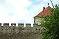 City walls
 Calvary
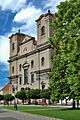 Jesuit church
 Lutheran church
 Pauline monastery
 Trinity church
 Franciscan monastery
 Romanesque rotunda
 Rotunda at night
 Garden in Skalica
References
- 1 2 Štefánik, Martin; Lukačka, Ján, eds. (2010). Lexikón stredovekých miest na Slovensku [Lexicon of Medieval Towns in Slovakia] (PDF) (in Slovak). Bratislava: Historický ústav SAV. p. 43. ISBN 978-80-89396-11-5.
- ↑ http://www.zahorskemuzeum.sk/?q=page/155
- ↑ http://books.google.sk/books?id=aHcvAAAAIAAJ&q=Skalica+velka+morava&dq=Skalica+velka+morava&hl=sk&ei=TiflTpi1CcXBtAbU1NSxCQ&sa=X&oi=book_result&ct=result&sqi=2&redir_esc=y
- ↑ Jan Velinger, Famous Art Nouveau gem set to reopen http://www.radio.cz/en/section/curraffrs/famous-art-nouveau-gem-set-to-reopen
- 1 2 "Municipal Statistics". Statistical Office of the Slovak republic. Archived from the original on 2007-11-16. Retrieved 2007-12-09.
- ↑ "Felvidek Ma" (in Hungarian). Szövetség a Közös Célokért. 2008. Retrieved 8 April 2008.
- ↑ "Kulturális enciklopédia" (in Hungarian). Osztovits Szabolcs. 2008. Retrieved 8 April 2008.
External links
Municipalities of Skalica District | ||
|---|---|---|