Sireuil
| Sireuil | |
|---|---|
|
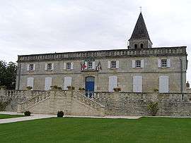
Town hall | |
 Sireuil | |
|
Location within Nouvelle-Aquitaine region  Sireuil | |
| Coordinates: 45°36′59″N 0°00′38″E / 45.6164°N 0.0106°ECoordinates: 45°36′59″N 0°00′38″E / 45.6164°N 0.0106°E | |
| Country | France |
| Region | Nouvelle-Aquitaine |
| Department | Charente |
| Arrondissement | Angoulême |
| Canton | Hiersac |
| Intercommunality | Charente-Boëme-Charraud |
| Government | |
| • Mayor (2008–2014) | Régis Rouyer |
| Area1 | 10.01 km2 (3.86 sq mi) |
| Population (2008)2 | 1,183 |
| • Density | 120/km2 (310/sq mi) |
| Time zone | CET (UTC+1) |
| • Summer (DST) | CEST (UTC+2) |
| INSEE/Postal code | 16370 / 16440 |
| Elevation |
20–87 m (66–285 ft) (avg. 27 m or 89 ft) |
|
1 French Land Register data, which excludes lakes, ponds, glaciers > 1 km² (0.386 sq mi or 247 acres) and river estuaries. 2 Population without double counting: residents of multiple communes (e.g., students and military personnel) only counted once. | |
Sireuil is a commune in the Charente department in southwestern France.
Population
| Historical population | ||
|---|---|---|
| Year | Pop. | ±% |
| 1793 | 673 | — |
| 1800 | 764 | +13.5% |
| 1806 | 746 | −2.4% |
| 1821 | 821 | +10.1% |
| 1831 | 639 | −22.2% |
| 1841 | 847 | +32.6% |
| 1846 | 892 | +5.3% |
| 1851 | 813 | −8.9% |
| 1856 | 933 | +14.8% |
| 1861 | 889 | −4.7% |
| 1866 | 937 | +5.4% |
| 1872 | 914 | −2.5% |
| 1876 | 964 | +5.5% |
| 1881 | 872 | −9.5% |
| 1886 | 609 | −30.2% |
| 1891 | 535 | −12.2% |
| 1896 | 643 | +20.2% |
| 1901 | 771 | +19.9% |
| 1906 | 748 | −3.0% |
| 1911 | 795 | +6.3% |
| 1921 | 689 | −13.3% |
| 1926 | 754 | +9.4% |
| 1931 | 930 | +23.3% |
| 1936 | 903 | −2.9% |
| 1946 | 919 | +1.8% |
| 1954 | 947 | +3.0% |
| 1962 | 978 | +3.3% |
| 1968 | 1,023 | +4.6% |
| 1975 | 989 | −3.3% |
| 1982 | 899 | −9.1% |
| 1990 | 1,121 | +24.7% |
| 1999 | 1,124 | +0.3% |
| 2008 | 1,183 | +5.2% |
See also
References
| Wikimedia Commons has media related to Sireuil (Charente). |
This article is issued from Wikipedia - version of the 3/15/2016. The text is available under the Creative Commons Attribution/Share Alike but additional terms may apply for the media files.