Sir Matt Busby Way
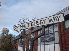
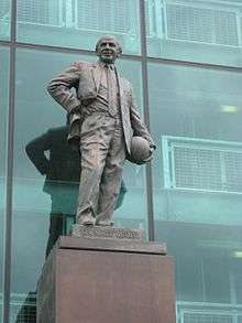
Sir Matt Busby Way is a road in Old Trafford, Greater Manchester, England. It is the location of Manchester United's Old Trafford football ground. Formerly known as Warwick Road North, it was renamed in honour of the legendary Manchester United manager, Sir Matt Busby, in 1993. Busby died less than a year later on 20 January 1994, aged 84.[1] A bronze statue of Sir Matt Busby, erected in 1996, stands on the exterior of the East Stand of the Old Trafford stadium, overlooking Sir Matt Busby Way.
The road is approximately 420 metres (459 yd) long and runs from Chester Road (A56) to Trafford Park Road/Wharfside Way (A5081). It also leads onto United Road, which runs under the North Stand of the Old Trafford stadium, and Railway Road, which runs alongside the railway line adjacent to the stadium.
In June 2011, Manchester United and Trafford Council began the process of permanently pedestrianising Sir Matt Busby Way.[2][3] It was previously completely open to traffic, except for short periods during events at the Old Trafford stadium. The restrictions, which were introduced on 12 December 2008, meant the road would close three hours prior to an event and reopen two hours afterwards.[4]
References
- ↑ Welsh, Pamela (28 December 2009). "End of the road for cars on Busby Way". Manchester Evening News. MEN Media. Retrieved 30 June 2011.
- ↑ "Sir Matt Busby Way closure". Trafford Council. 1 June 2011. Retrieved 30 June 2011.
- ↑ Keegan, Mike (7 June 2011). "Red card to cars: Sir Matt Busby Way closed to traffic outside Manchester United's Old Trafford stadium". Manchester Evening News. MEN Media. Retrieved 30 June 2011.
- ↑ "Borough to Trafford Order 2008" (PDF). Trafford Council. 27 November 2008. Retrieved 31 December 2008.
| History | |
|---|---|
| Munich air disaster | |
| Home stadium |
|
| Training ground | |
| Players | |
| Rivalries | |
| Supporters | |
| Media | |
| Related articles | |
| |
Coordinates: 53°27′48″N 2°17′21″W / 53.4633°N 2.2893°W