Sipalay
| Sipalay | ||
|---|---|---|
| Component City | ||
| City of Sipalay | ||
|
Sipalay beach | ||
| ||
| Nickname(s): "The Jewel of the Sugar Island" | ||
| Motto: "Ugyon Sipalaynon" | ||
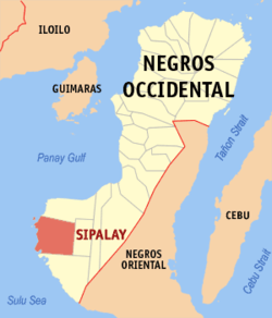 Map of Negros Occidental with Sipalay highlighted | ||
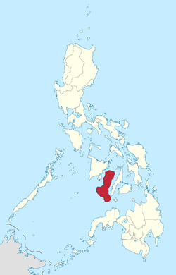
.svg.png) Sipalay Location within the Philippines | ||
| Coordinates: 09°45′N 122°24′E / 9.750°N 122.400°ECoordinates: 09°45′N 122°24′E / 9.750°N 122.400°E | ||
| Country |
| |
| Region | Negros Island Region (NIR) | |
| Province | Negros Occidental | |
| Congr. District | 6th District of Negros Occidental | |
| Cityhood | March 31, 2001 | |
| Barangays | 17 | |
| Government | ||
| • Mayor | Oscar C. Montilla, Jr. | |
| • Vice Mayor | Ma. Gina M. Lizares | |
| Area[1] | ||
| • Total | 379.78 km2 (146.63 sq mi) | |
| Population (2015)[2] | ||
| • Total | 70,070 | |
| • Density | 180/km2 (480/sq mi) | |
| Time zone | PST (UTC+8) | |
| ZIP code | 6113 | |
| Dialing code | 034 | |
| Income class | 4th class city; partially urban | |
| Website |
www | |
| Tourism Information Center: New Government Center, Upper Ground Floor, Right Wing, Sipalay City, Negros Occidental 6113, Philippines[3] | ||
.jpg)

Sipalay, officially the City of Sipalay (Hiligaynon: Dakbanwa/Syudad sang Sipalay; Filipino: Lungsod ng Sipalay) or simply referred to as Sipalay City, is a fourth-class component city in the province of Negros Occidental in Negros Island Region, Philippines. According to the 2015 census, it has a population of 70,070 inhabitants.
History

Sipalay history can be traced back to the undated time of early settlements of the natives Tumandok who discovered the lowland plains very fertile, arable and fully vegetated by trees. the areas was well dissected by river tributaries which accounted for the fertility of the lowland.
During the Spanish era, the area was further discovered and developed by sailing adventurers from the neighboring island of Panay, being the group who resented the Kintos System enacted by the ruling Spaniards by then.
Growth and development flourished as Chinese merchants came to barter their wares with staple food, particularly rice, which was commonly called by the settlers as para and by the Chinese, due to the difficulty of pronouncing y, as palay which was the word to have been popularly associated with the place. Thus the area came to be known as Sipalay.
At the advent of the American regime, Sipalay was a full pledge barrio of the Municipality of Cauayan. In the early 1920s the political structure was already in place.
During the World War II, Sipalay was made an emergency town and after the war, late President Elpidio Quirino signed Executive Order No. 185 proclaiming Sipalay as a town. the official inauguration of the town was on December 20, 1948. the conversion of Sipalay into a component city of the Province of Negros Occidental followed in 2011.[3]
Tourism
The city is known for its tourist destinations. An example of it is the now-defunct Maricalum Mining Corporation which happens to be one of the largest mining companies in the country. It now has a park dedicated for viewing the whole mine from atop.
It also boasts beautiful pristine beaches being a seaside city. Dubbed as the New Boracay, foreign and local tourists flock its beaches the whole year round for not only for swimming but for diving as well.
Language
Major languages are Hiligaynon, followed by Cebuano with English and Filipino being used as second languages.
Barangays

Sipalay City is politically subdivided into 17 barangays.[1]
- Barangay 1 (Pob.)
- Barangay 2 (Pob.)
- Barangay 3 (Pob.)
- Barangay 4 (Pob.)
- Barangay 5 (Pob.)
- Cabadiangan
- Camindangan
- Canturay
- Cartagena
- Cayhagan
- Gil Montilla
- Mambaroto
- Manlucahoc
- Maricalum
- Nabulao
- Nauhang
- San Jose
Demographics
| Population census of Sipalay | ||
|---|---|---|
| Year | Pop. | ±% p.a. |
| 1990 | 61,892 | — |
| 1995 | 63,960 | +0.62% |
| 2000 | 62,063 | −0.64% |
| 2007 | 67,211 | +1.11% |
| 2010 | 67,403 | +0.10% |
| 2015 | 70,070 | +0.74% |
| Source: National Statistics Office[2][4] | ||
Accessibility
Sipalay's distance from Bacolod City is 175 kilometers, almost a four-hour drive by public utility vehicle and over three hours by private car. Public utility vehicles plying the southern Negros route pass by this city. Those coming from Negros Oriental can either exit through Kabankalan City via Mabinay or through Dumaguete City via Hinoba-an.
References
- 1 2 "Province: Negros Occidental". PSGC Interactive. Makati City, Philippines: National Statistical Coordination Board. Retrieved 5 March 2013.
- 1 2 "NEGROS ISLAND REGION (NIR)". Census of Population (2015): Total Population by Province, City, Municipality and Barangay (Report). PSA. Retrieved 20 June 2016.
- 1 2 Sipalay City Tourism Pamphlet
- ↑ "Province of Negros Occidental". Municipality Population Data. LWUA Research Division. Retrieved 16 August 2013.
External links
 Media related to Sipalay City at Wikimedia Commons
- Sipalay City Official Website
- Philippine Standard Geographic Code
- Philippine Census Information
- Local Governance Performance Management System
 |
Cauayan | | ||
| Sulu Sea | |
Candoni | ||
| ||||
| | ||||
| Hinoba-an |