Sioux County, Iowa
| Sioux County, Iowa | |
|---|---|
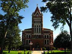 Sioux County Courthouse | |
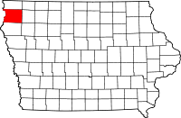 Location in the U.S. state of Iowa | |
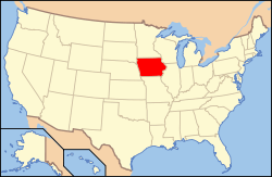 Iowa's location in the U.S. | |
| Founded | 1851 |
| Named for | Sioux people |
| Seat | Orange City |
| Largest city | Sioux Center |
| Area | |
| • Total | 769 sq mi (1,992 km2) |
| • Land | 768 sq mi (1,989 km2) |
| • Water | 0.7 sq mi (2 km2), 0.09% |
| Population | |
| • (2010) | 33,704 |
| • Density | 44/sq mi (17/km²) |
| Congressional district | 4th |
| Time zone | Central: UTC-6/-5 |
| Website |
www |
Sioux County is a county located in the U.S. state of Iowa. As of the 2010 census, the population was 33,704.[1] Its county seat is Orange City.[2]
History
Sioux County was formed on January 15, 1851. It has been self-governed since January 20, 1860. It was named after the Sioux tribe.[3]
The first county seat was Calliope in 1860, then a small village with 15 inhabitants, and now part of Hawarden. The first courthouse was built here in 1860 and served as such until 1872. A larger immigration wave began in 1869, primarily of Dutch. In 1872, Orange City was declared the seat. In June 1902, the construction began on a new Sioux County courthouse designed by W.W. Beach. Of red sandstone, it was completed in 1904, and still serves as the courthouse. From 1976 until 1982 the building was completely restored, and in 1977, it was listed on the National Register of Historic Places.
Geography
According to the U.S. Census Bureau, the county has a total area of 769 square miles (1,990 km2), of which 768 square miles (1,990 km2) is land and 0.7 square miles (1.8 km2) (0.09%) is water.[4]
Western Sioux County drains to the south west to the Rock River or the Big Sioux River. Eastern Sioux County drains to the south east to the Floyd River.
Major highways
Adjacent counties
- Lyon County (north)
- O'Brien County (east)
- Plymouth County (south)
- Union County, South Dakota (southwest)
- Lincoln County, South Dakota (northwest)
Demographics
| Historical population | |||
|---|---|---|---|
| Census | Pop. | %± | |
| 1860 | 10 | — | |
| 1870 | 576 | 5,660.0% | |
| 1880 | 5,426 | 842.0% | |
| 1890 | 18,370 | 238.6% | |
| 1900 | 23,337 | 27.0% | |
| 1910 | 25,248 | 8.2% | |
| 1920 | 26,458 | 4.8% | |
| 1930 | 26,806 | 1.3% | |
| 1940 | 27,209 | 1.5% | |
| 1950 | 26,381 | −3.0% | |
| 1960 | 26,375 | 0.0% | |
| 1970 | 27,996 | 6.1% | |
| 1980 | 30,813 | 10.1% | |
| 1990 | 29,903 | −3.0% | |
| 2000 | 31,589 | 5.6% | |
| 2010 | 33,704 | 6.7% | |
| Est. 2015 | 34,937 | [5] | 3.7% |
| U.S. Decennial Census[6] 1790-1960[7] 1900-1990[8] 1990-2000[9] 2010-2014[1] | |||
2010 census
The 2010 census recorded a population of 33,704 in the county, with a population density of 43.8923/sq mi (16.9469/km2). There were 12,279 housing units, of which 11,584 were occupied.[10]
2000 census

As of the census[11] of 2000, there were 31,589 people, 10,693 households, and 8,062 families residing in the county. The population density was 41 people per square mile (16/km²). There were 11,260 housing units at an average density of 15 per square mile (6/km²). The racial makeup of the county was 97.33% White, 0.20% Black or African American, 0.13% Native American, 0.59% Asian, 0.01% Pacific Islander, 1.20% from other races, and 0.53% from two or more races. 2.56% of the population were Hispanic or Latino of any race.
There were 10,693 households out of which 36.80% had children under the age of 18 living with them, 69.40% were married couples living together, 4.20% had a female householder with no husband present, and 24.60% were non-families. 22.20% of all households were made up of individuals and 11.40% had someone living alone who was 65 years of age or older. The average household size was 2.71 and the average family size was 3.19.
In the county the population was spread out with 27.10% under the age of 18, 15.20% from 18 to 24, 23.50% from 25 to 44, 19.10% from 45 to 64, and 15.00% who were 65 years of age or older. The median age was 33 years. For every 100 females there were 96.30 males. For every 100 females age 18 and over, there were 93.50 males.
The median income for a household in the county was $40,536, and the median income for a family was $45,846. Males had a median income of $31,548 versus $19,963 for females. The per capita income for the county was $16,532. About 4.60% of families and 6.40% of the population were below the poverty line, including 7.90% of those under age 18 and 6.80% of those age 65 or over.
At one time divorce was relatively uncommon. In 1980, 52 married people in the county existed per divorced person; this rate did not exist in the total United States since the 1930s.[12] As of 2011, this changed to 14 married persons per divorced person.[12]
Religion
As of 2011, 80% of Sioux County residents were descendants of Dutch immigrants. Therefore, 80% of the county residents belong to major denominational churches, compared to 36% of the total U.S. population.[12]
Education
Sioux County is the home to two four-year liberal arts colleges; Northwestern College in Orange City and Dordt College in Sioux Center. Both of these schools have enrollments over 1,000. Northwest Iowa Community College is also in Sioux County, though it is most often associated with the community of Sheldon in O'Brien County.
Politics
The county is historically Republican in Presidential elections.[13] The last Democrat to carry the county was Franklin D. Roosevelt in 1936.[14] In 1992, Sioux County was one of only two counties in the nation to give George H.W. Bush over 70% of their vote.[15] In the four elections since then, the Republican candidates has never received less than 75% of the county's vote.[16] It is located in what was, until 2013, Iowa's 5th congressional district which had a Cook Partisan Voting Index of R+9 and was represented by Republican Steve King. King won the seat in Iowa's new 4th congressional district in the 2012 election[17] with 53% of the district's vote, with 83% of Sioux County votes going for King.[18]
Communities
Cities
Population ranking
The population ranking of the following table is based on the 2010 census of Sioux County.[19]
† county seat
| Rank | City/Town/etc. | Municipal type | Population (2010 Census)
|
|---|---|---|---|
| 1 | Sioux Center | City | 7,048 |
| 2 | † Orange City | City | 6,004 |
| 3 | Sheldon (partially in O' Brien) | City | 5,188 |
| 4 | Rock Valley | City | 3,354 |
| 5 | Hawarden | City | 2,546 |
| 6 | Hull | City | 2,175 |
| 7 | Alton | City | 1,216 |
| 8 | Boyden | City | 707 |
| 9 | Hospers | City | 698 |
| 10 | Ireton | City | 609 |
| 11 | Granville | City | 312 |
| 12 | Maurice | City | 275 |
| 13 | Matlock | City | 87 |
| 14 | Chatsworth | City | 79 |
Notable natives
- Vern Den Herder, member of the undefeated Miami Dolphins NFL team of 1972.
- Hope Emerson, American actress.
- Stanley L. Greigg, member of the U.S. House of Representatives.
- Brian Hansen, former NFL punter.
- Charles B. Hoeven, U.S. Representative.
- Millie Jeffrey, pioneer for workers', civil and women's rights.
- James Kennedy, American historian.
- Stephen A. Mitchell (Democratic activist)
- Nancy Metcalf, professional volleyball player
- Albert J. Meyer (economist).
- Dennis Marion Schnurr, Archbishop of the Roman Catholic Archdiocese of Cincinnati
- Robert H. Schuller, American televangelist, pastor, and author.
- Ruth Suckow, American author.
- Melvin D. Synhorst, former Iowa Secretary of State.
- Delwin Vriend, LGBT rights icon.
- Anna Johnson Pell Wheeler, American mathematician.
- Dennis A. Muilenburg, CEO of Boeing
See also
References
- 1 2 "State & County QuickFacts". United States Census Bureau. Retrieved July 20, 2014.
- ↑ "Find a County". National Association of Counties. Retrieved 2011-06-07.
- ↑ Chicago and North Western Railway Company (1908). A History of the Origin of the Place Names Connected with the Chicago & North Western and Chicago, St. Paul, Minneapolis & Omaha Railways. p. 163.
- ↑ "US Gazetteer files: 2010, 2000, and 1990". United States Census Bureau. 2011-02-12. Retrieved 2011-04-23.
- ↑ "County Totals Dataset: Population, Population Change and Estimated Components of Population Change: April 1, 2010 to July 1, 2015". Retrieved July 2, 2016.
- ↑ "U.S. Decennial Census". United States Census Bureau. Retrieved July 20, 2014.
- ↑ "Historical Census Browser". University of Virginia Library. Retrieved July 20, 2014.
- ↑ "Population of Counties by Decennial Census: 1900 to 1990". United States Census Bureau. Retrieved July 20, 2014.
- ↑ "Census 2000 PHC-T-4. Ranking Tables for Counties: 1990 and 2000" (PDF). United States Census Bureau. Retrieved July 20, 2014.
- ↑ "Population and Housing Occupancy Status: 2010 - State -- County". United States Census Bureau American FactFinder. Retrieved March 26, 2011.
- ↑ "American FactFinder". United States Census Bureau. Retrieved 2008-01-31.
- 1 2 3 Tavernise, Sabrina; Gebeloff, Robert (March 23, 2011). "Once Rare in Rural America, Divorce Is Changing the Face of Its Families". New York Times. Retrieved March 24, 2011.
- ↑ David Leip's Presidential Atlas (Maps for Iowa by election)
- ↑ Geographie Electorale
- ↑ David Leip's Presidential Atlas: 1992 Presidential election statistics
- ↑ The New York Times electoral map (Zoom in on Iowa)
- ↑ Hayworth, Bret (11/6/12). "King wins sixth term in House". Sioux City Journal. Retrieved 1/7/13. Check date values in:
|access-date=, |date=(help) - ↑ "Iowa 4th District Congressional Election Results, by County". 2012 General Election Results. Iowa Secretary of State. Retrieved 1/7/13. Check date values in:
|access-date=(help) - ↑ http://www.census.gov/2010census/
External links
| Wikimedia Commons has media related to Sioux County, Iowa. |
 |
Lincoln County, South Dakota | Lyon County | | |
| |
O'Brien County | |||
| ||||
| | ||||
| Union County, South Dakota | Plymouth County |
Municipalities and communities of Sioux County, Iowa, United States | ||
|---|---|---|
| Cities | ||
| Unincorporated communities | ||
| Footnotes | ‡This populated place also has portions in an adjacent county or counties | |

Coordinates: 43°04′53″N 96°10′46″W / 43.08139°N 96.17944°W