Sinking Spring, Ohio
| Sinking Spring, Ohio | |
|---|---|
| Village | |
 Location of Sinking Spring, Ohio | |
 Location of Sinking Spring in Highland County | |
| Coordinates: 39°4′27″N 83°23′14″W / 39.07417°N 83.38722°WCoordinates: 39°4′27″N 83°23′14″W / 39.07417°N 83.38722°W | |
| Country | United States |
| State | Ohio |
| County | Highland |
| Area[1] | |
| • Total | 0.47 sq mi (1.22 km2) |
| • Land | 0.47 sq mi (1.22 km2) |
| • Water | 0 sq mi (0 km2) |
| Elevation[2] | 866 ft (264 m) |
| Population (2010)[3] | |
| • Total | 133 |
| • Estimate (2012[4]) | 132 |
| • Density | 283.0/sq mi (109.3/km2) |
| Time zone | Eastern (EST) (UTC-5) |
| • Summer (DST) | EDT (UTC-4) |
| ZIP code | 45172 |
| Area code(s) | 937 |
| FIPS code | 39-72578[5] |
| GNIS feature ID | 1065330[2] |
Sinking Spring is a village in Highland County, Ohio, United States. The population was 133 at the 2010 census.
History
A post office called Sinking Spring has been in operation since 1817.[6] The village was named for a losing stream near the original town site.[7]
Geography
Sinking Spring is located at 39°4′27″N 83°23′14″W / 39.07417°N 83.38722°W (39.074266, -83.387139).[8]
According to the United States Census Bureau, the village has a total area of 0.47 square miles (1.22 km2), all land.[1]
Gallery
| Wikimedia Commons has media related to Sinking Spring, Ohio. |
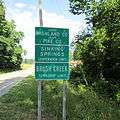 Sinking Spring corporation limit sign.
..jpg) Looking south on Main Street (Ohio Highway 41) in Sinking Spring, Ohio.
Looking south on Main Street (Ohio Highway 41) in Sinking Spring, Ohio. Octagonal Schoolhouse constructed in 1831.
 Sinking Spring Community Center. Former gymnasium for Sinking Spring High School. Constructed in 1938 with rear addition added in 1951.
 Interior of Community Center.
 Interior of Community Center.
 Interior of Community Center.
 Interior of Community Center.
 Sinking Spring Methodist Church. This building was constructed in 1844 and is the oldest church in Highland County, Ohio still being used as a church.
 Grace Bible Church.
 Pathway To Christ Church.
 Cornerstone of the former Sinking Spring High School outside of Community Center. Set in place on May 14, 2010.
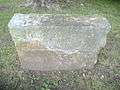 Stone outside Community Center. Inscription reads "Gene Deardoff May 21, 1938".
 Site of the former Sinking Spring High School. The building was destroyed by fire on March 25, 1998.
 Sinking Spring Masonic Lodge constructed in 1894.
 Family Dollar store.
 Brushcreek Township Fire Department.
 Brushcreek Township Fire Department Station 2 located in Carmel, Ohio.
 Pleasant Hill Cemetery.
Demographics
| Historical population | |||
|---|---|---|---|
| Census | Pop. | %± | |
| 1830 | 109 | — | |
| 1840 | 75 | −31.2% | |
| 1870 | 200 | — | |
| 1880 | 107 | −46.5% | |
| 1900 | 238 | — | |
| 1910 | 187 | −21.4% | |
| 1920 | 128 | −31.6% | |
| 1930 | 177 | 38.3% | |
| 1940 | 223 | 26.0% | |
| 1950 | 187 | −16.1% | |
| 1960 | 202 | 8.0% | |
| 1970 | 178 | −11.9% | |
| 1980 | 239 | 34.3% | |
| 1990 | 189 | −20.9% | |
| 2000 | 158 | −16.4% | |
| 2010 | 133 | −15.8% | |
| Est. 2015 | 133 | [9] | 0.0% |
2010 census
As of the census[3] of 2010, there were 133 people, 53 households, and 37 families residing in the village. The population density was 283.0 inhabitants per square mile (109.3/km2). There were 62 housing units at an average density of 131.9 per square mile (50.9/km2). The racial makeup of the village was 100.0% White.
There were 53 households of which 28.3% had children under the age of 18 living with them, 50.9% were married couples living together, 17.0% had a female householder with no husband present, 1.9% had a male householder with no wife present, and 30.2% were non-families. 24.5% of all households were made up of individuals and 13.2% had someone living alone who was 65 years of age or older. The average household size was 2.51 and the average family size was 3.03.
The median age in the village was 45.2 years. 23.3% of residents were under the age of 18; 7.5% were between the ages of 18 and 24; 18.9% were from 25 to 44; 27.1% were from 45 to 64; and 23.3% were 65 years of age or older. The gender makeup of the village was 49.6% male and 50.4% female.
2000 census
As of the census[5] of 2000, there were 158 people, 57 households, and 44 families residing in the village. The population density was 337.6 people per square mile (129.8/km²). There were 63 housing units at an average density of 134.6 per square mile (51.8/km²). The racial makeup of the village was 97.47% White, 1.90% Native American, and 0.63% from two or more races.
There were 57 households out of which 45.6% had children under the age of 18 living with them, 61.4% were married couples living together, 12.3% had a female householder with no husband present, and 21.1% were non-families. 17.5% of all households were made up of individuals and 15.8% had someone living alone who was 65 years of age or older. The average household size was 2.77 and the average family size was 3.04.
In the village the population was spread out with 27.8% under the age of 18, 8.9% from 18 to 24, 34.8% from 25 to 44, 15.2% from 45 to 64, and 13.3% who were 65 years of age or older. The median age was 32 years. For every 100 females there were 88.1 males. For every 100 females age 18 and over, there were 83.9 males.
The median income for a household in the village was $38,750, and the median income for a family was $47,500. Males had a median income of $38,333 versus $21,875 for females. The per capita income for the village was $15,089. About 7.7% of families and 7.7% of the population were below the poverty line, including none of those under the age of eighteen and 28.6% of those sixty five or over.
Notable person
- Charles Willing Byrd — early Ohio political leader and jurist
References
- 1 2 "US Gazetteer files 2010". United States Census Bureau. Retrieved 2013-01-06.
- 1 2 "US Board on Geographic Names". United States Geological Survey. 2007-10-25. Retrieved 2008-01-31.
- 1 2 "American FactFinder". United States Census Bureau. Retrieved 2013-01-06.
- ↑ "Population Estimates". United States Census Bureau. Retrieved 2013-06-17.
- 1 2 "American FactFinder". United States Census Bureau. Retrieved 2008-01-31.
- ↑ "Post offices". Jim Forte Postal History. Retrieved 20 June 2016.
- ↑ Overman, William Daniel (1958). Ohio Town Names. Akron, OH: Atlantic Press. p. 127.
- ↑ "US Gazetteer files: 2010, 2000, and 1990". United States Census Bureau. 2011-02-12. Retrieved 2011-04-23.
- ↑ "Annual Estimates of the Resident Population for Incorporated Places: April 1, 2010 to July 1, 2015". Retrieved July 2, 2016.
- ↑ "Census of Population and Housing". Census.gov. Retrieved June 4, 2015.
Municipalities and communities of Highland County, Ohio, United States | ||
|---|---|---|
| City | 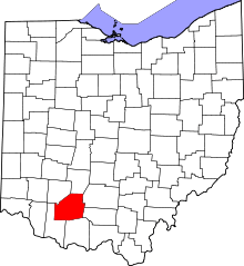 | |
| Villages | ||
| Townships | ||
| CDPs | ||
| Unincorporated communities | ||
| Footnotes | ‡This populated place also has portions in an adjacent county or counties | |