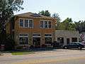
Silverhill, Alabama
| Silverhill, Alabama | |
|---|---|
| Town | |
 Location in Baldwin County and the state of Alabama | |
| Coordinates: 30°32′43″N 87°45′2″W / 30.54528°N 87.75056°W | |
| Country | United States |
| State | Alabama |
| County | Baldwin |
| Area | |
| • Total | 1.2 sq mi (3.1 km2) |
| • Land | 1.2 sq mi (3.1 km2) |
| • Water | 0 sq mi (0 km2) |
| Elevation | 141 ft (43 m) |
| Population (2010) | |
| • Total | 706 |
| • Density | 590/sq mi (227.8/km2) |
| Time zone | Central (CST) (UTC-6) |
| • Summer (DST) | CDT (UTC-5) |
| ZIP code | 36576 |
| Area code(s) | 251 |
| FIPS code | 01-70536 |
| GNIS feature ID | 0126858 |
Silverhill is a town in Baldwin County, Alabama, United States. As of the 2010 census, the population was 706.[1] It is part of the Daphne–Fairhope–Foley Micropolitan Statistical Area.
Geography
Silverhill is located in southern Baldwin County at 30°32'42.950" North, 87°45'1.861" West (30.545264, -87.750517),[2] 3 miles (5 km) west of Robertsdale. Alabama State Route 104 (Silverhill Avenue) runs through the center of the town, connecting Robertsdale to the east with Fairhope to the west.
According to the U.S. Census Bureau, the town has a total area of 1.2 square miles (3.1 km2), all land.[1]
Demographics
| Historical population | |||
|---|---|---|---|
| Census | Pop. | %± | |
| 1930 | 314 | — | |
| 1940 | 270 | −14.0% | |
| 1950 | 354 | 31.1% | |
| 1960 | 417 | 17.8% | |
| 1970 | 552 | 32.4% | |
| 1980 | 624 | 13.0% | |
| 1990 | 556 | −10.9% | |
| 2000 | 616 | 10.8% | |
| 2010 | 706 | 14.6% | |
| Est. 2015 | 761 | [3] | 7.8% |
| U.S. Decennial Census[4] 2013 Estimate[5] | |||
As of the census[6] of 2000, there were 616 people, 241 households, and 178 families residing in the town. The population density was 517.5 people per square mile (199.9/km²). There were 266 housing units at an average density of 223.5 per square mile (86.3/km²). The racial makeup of the town was 98.05% White, 0.16% Native American, 0.65% Asian, and 1.14% from two or more races. 1.46% of the population were Hispanic or Latino of any race. 24.8% were of American, 14.8% German, 10.2% Swedish, 9.0% English and 6.4% Irish ancestry according to Census 2000.
There were 241 households out of which 32.4% had children under the age of 18 living with them, 61.8% were married couples living together, 8.7% had a female householder with no husband present, and 26.1% were non-families. 20.7% of all households were made up of individuals and 10.4% had someone living alone who was 65 years of age or older. The average household size was 2.54 and the average family size was 2.97.
In the town the population was spread out with 25.2% under the age of 18, 6.5% from 18 to 24, 25.8% from 25 to 44, 26.3% from 45 to 64, and 16.2% who were 65 years of age or older. The median age was 40 years. For every 100 females there were 91.3 males. For every 100 females age 18 and over, there were 88.2 males.
The median income for a household in the town was $42,083, and the median income for a family was $51,964. Males had a median income of $30,417 versus $25,938 for females. The per capita income for the town was $20,723. About 3.8% of families and 4.8% of the population were below the poverty line, including 4.6% of those under age 18 and 5.1% of those age 65 or over.
History
Silverhill was founded in 1897 by Oscar Johnson, C. O. Carlson and C. A. Valentin of Chicago, Illinois. Oscar Johnson was an immigrant from Dalarna, Sweden. The Svea Land Company in Chicago, which advertised land for sale in Silverhill, was founded by Oscar Johnson. Land was acquired by purchase from a Mr. Harford, the first block of land being 1,500 acres (610 ha), which was added to from time to time as the colonization work progressed. Scandinavian settlers came to Silverhill from virtually every state in the Union and began the development of what is now the Silverhill district.[7][8]
The Wales West Light Railway, a replica of a Welsh mountain railway, is located 5 miles (8 km) southwest of town.
Education
Silverhill is a part of the Baldwin County Public Schools system. Silverhill has one school, Silverhill Elementary School, which serves grades kindergarten through 6. Silverhill students continue on to Central Baldwin Middle School (7-8) and Robertsdale High School (9-12), both of which are in Robertsdale.[9]
Gallery


See also
References
- 1 2 "Geographic Identifiers: 2010 Demographic Profile Data (G001): Silverhill town, Alabama". U.S. Census Bureau, American Factfinder. Retrieved September 16, 2013.
- ↑ "US Gazetteer files: 2010, 2000, and 1990". United States Census Bureau. 2011-02-12. Retrieved 2011-04-23.
- ↑ "Annual Estimates of the Resident Population for Incorporated Places: April 1, 2010 to July 1, 2015". Retrieved July 2, 2016.
- ↑ "U.S. Decennial Census". Census.gov. Retrieved June 6, 2013.
- ↑ "Annual Estimates of the Resident Population: April 1, 2010 to July 1, 2013". Retrieved June 3, 2014.
- ↑ "American FactFinder". United States Census Bureau. Retrieved 2008-01-31.
- ↑ Vignettes of Baldwin County (Gulf Telephone Company. 1983)
- ↑ Silverhill (Scandinavians in Alabama)
- ↑ History of Silverhill School (written February 26, 2000 for the Annual Founders' Day Dinner)
External links
- Baldwin County Express, historical society located near Silverhill
Coordinates: 30°32′43″N 87°45′02″W / 30.545264°N 87.750517°W
Municipalities and communities of Baldwin County, Alabama, United States | ||
|---|---|---|
| Cities | 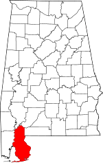 | |
| Towns | ||
| CDP | ||
| Unincorporated communities | ||
| Ghost town | ||