Silver Star Mountain (Okanogan County, Washington)
| Silver Star Mountain | |
|---|---|
 | |
| Highest point | |
| Elevation | 2,705 m (8,875 ft) |
| Prominence | 742 m (2,430 ft) |
| Coordinates | 48°32.88′N 120°35.11′W / 48.54800°N 120.58517°WCoordinates: 48°32.88′N 120°35.11′W / 48.54800°N 120.58517°W |
| Geography | |
| Location | Okanogan County, Washington |
| Parent range | Cascade Range |
| Topo map | USGS Silver Star Mountain |
| Climbing | |
| First ascent | Lage Wernstedt, 1926 |
| Easiest route | South Route |
Silver Star Mountain is a mountain located in Okanogan County, Washington. The mountain is part of the Cascade Range. It was first climbed by Lage Wernstedt in 1926.[1]
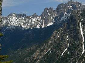
The summit ridge of Silver Star consists of a long ridge of spires (the Wine Spires) leading to the main summit. The mountain is a steep ragged wall as seen from the west on Highway 20. The north side glacier reaches to just below the ridge line. The easiest route is up the moderate glacier from the north via Silver Star Creek.
Silver Star Mountain stands within the watershed of the Methow River, which drains into the Columbia River's Lake Pateros reservoir, impounded by Wells Dam. The west and north sides of Silver Star drain into Early Winters Creek, thence into the Methow River. The southeast side of Silver Star drains into Cedar Creek, thence into Early Winters Creek.
Routes
East summit
- Silver Star Glacier class 3-4
- East ridge and spur class 5.8 Grade III
- Southeast Face and East ridge class 4-5 Grade II
West summit
- Southwest Buttress class 4
- West Buttress class 5.8 A1 Grade III
- Northeast Ridge class 5.9 Grade III
- Gato Negro class 5.10d
- Silver Star Glacier class 4
References
- ↑ Majors, Harry M. (1975). Exploring Washington. Van Winkle Publishing Co. p. 41. ISBN 978-0-918664-00-6.
External links
- "Silver Star Mountain". Geographic Names Information System. United States Geological Survey.
- "Silver Star Mountain, Washington". Peakbagger.com. Retrieved 2011-05-07.
- "Silver Star Mountain". SummitPost.org. Retrieved 2011-05-07.