Silver Bay, Minnesota
| Silver Bay, Minnesota | |
|---|---|
| City | |
|
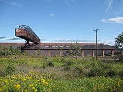
Taconite Plant in Silver Bay | |
 Location of the city of Silver Bay within Lake County, Minnesota | |
| Coordinates: 47°17′33″N 91°16′22″W / 47.29250°N 91.27278°W | |
| Country | United States |
| State | Minnesota |
| County | Lake |
| Area[1] | |
| • Total | 8.36 sq mi (21.65 km2) |
| • Land | 7.89 sq mi (20.44 km2) |
| • Water | 0.47 sq mi (1.22 km2) |
| Elevation | 764 ft (233 m) |
| Population (2010)[2] | |
| • Total | 1,887 |
| • Estimate (2012[3]) | 1,867 |
| • Density | 239.2/sq mi (92.4/km2) |
| Time zone | Central (CST) (UTC-6) |
| • Summer (DST) | CDT (UTC-5) |
| ZIP code | 55614 |
| Area code(s) | 218 |
| FIPS code | 27-60250[4] |
| GNIS feature ID | 0658258[5] |
| Website | www.silverbay.com |

Silver Bay is a city in Lake County, Minnesota, United States. The population was 1,887 at the 2010 census.[6]
Outer Drive (County Road 5), Penn Boulevard, and Minnesota Highway 61 are three of the main routes in Silver Bay.
Geography
According to the United States Census Bureau, the city has a total area of 8.36 square miles (21.65 km2), of which 7.89 square miles (20.44 km2) is land and 0.47 square miles (1.22 km2) is water.[1]
Silver Bay is located 28 miles northeast of the city of Two Harbors.
Tettegouche State Park, the Baptism River, and the Palisade Head rock formation are all nearby.
Summer hiking trails, winter cross country skiing, and maintained snowmobile trails are located within Silver Bay.
History
The city of Silver Bay was founded on May 1, 1954 after previously being known as the Beaver Bay housing project. The company town was built to process taconite mined and shipped by train from Babbitt, Minnesota, sixty miles to the northwest.[7]
Silver Bay attained widespread publicity in the 1960s when it was discovered that the Reserve Corporation was dumping taconite tailings into Lake Superior. In 1972 they were forced to stop and charged with violating the Rivers and Harbors Act of 1899, which prohibited the dumping of harmful materials into interstate waters. In 1977, after a long trial, a new waste-storage facility was built 7 miles inland.
Demographics
| Historical population | |||
|---|---|---|---|
| Census | Pop. | %± | |
| 1960 | 3,723 | — | |
| 1970 | 3,504 | −5.9% | |
| 1980 | 2,917 | −16.8% | |
| 1990 | 1,894 | −35.1% | |
| 2000 | 2,068 | 9.2% | |
| 2010 | 1,887 | −8.8% | |
| Est. 2015 | 1,813 | [8] | −3.9% |
| U.S. Decennial Census | |||
2010 census
As of the census[2] of 2010, there were 1,887 people, 836 households, and 542 families residing in the city. The population density was 239.2 inhabitants per square mile (92.4/km2). There were 974 housing units at an average density of 123.4 per square mile (47.6/km2). The racial makeup of the city was 97.9% White, 0.2% African American, 0.3% Native American, 0.3% Asian, 0.3% from other races, and 1.0% from two or more races. Hispanic or Latino of any race were 0.9% of the population.
There were 836 households of which 22.8% had children under the age of 18 living with them, 53.3% were married couples living together, 6.7% had a female householder with no husband present, 4.8% had a male householder with no wife present, and 35.2% were non-families. 31.7% of all households were made up of individuals and 15.9% had someone living alone who was 65 years of age or older. The average household size was 2.17 and the average family size was 2.69.
The median age in the city was 50.1 years. 18.4% of residents were under the age of 18; 6.9% were between the ages of 18 and 24; 17.4% were from 25 to 44; 28.6% were from 45 to 64; and 28.8% were 65 years of age or older. The gender makeup of the city was 51.8% male and 48.2% female.
2000 census
As of the census[4] of 2000, there were 2,068 people, 844 households, and 589 families residing in the city. The population density was 268.0 people per square mile (103.4/km²). There were 933 housing units at an average density of 120.9 per square mile (46.7/km²). The racial makeup of the city was 97.68% White, 0.05% African American, 1.11% Native American, 0.15% Asian, 0.05% Pacific Islander, 0.10% from other races, and 0.87% from two or more races. Hispanic or Latino of any race were 0.68% of the population. Germans comprised 22.2% of the population, 18.1% Norwegian, 11.5% Swedish, 6.5% Finnish, 6.4% American, 6.1% Irish, and 5.2% English ancestry according to Census 2000.
There were 844 households out of which 28.2% had children under the age of 18 living with them, 59.8% were married couples living together, 7.1% had a female householder with no husband present, and 30.1% were non-families. Individuals comprised 27.6% of all households and 14.3% had someone living alone who was 65 years of age or older. The average household size was 2.35 and the average family size was 2.85.
In the city the population was spread out with 24.4% under the age of 18, 4.3% from 18 to 24, 23.4% from 25 to 44, 20.8% from 45 to 64, and 27.2% who were 65 years of age or older. The median age was 44 years. For every 100 females there were 104.8 males. For every 100 females age 18 and over, there were 105.8 males.
The median income for a household in the city was $36,524, and the median income for a family was $41,667. Males had a median income of $40,655 versus $25,809 for females. The per capita income for the city was $16,958. About 5.3% of families and 6.8% of the population were below the poverty line, including 8.5% of those under age 18 and 2.9% of those age 65 or over.
Transportation
Silver Bay is served by the Silver Bay Municipal Airport.
Outer Drive (County Road 5), Penn Boulevard, and Minnesota Highway 61 are three of the main routes in Silver Bay.
References
- 1 2 "US Gazetteer files 2010". United States Census Bureau. Retrieved 2012-11-13.
- 1 2 "American FactFinder". United States Census Bureau. Retrieved 2012-11-13.
- ↑ "Population Estimates". United States Census Bureau. Retrieved 2013-05-28.
- 1 2 "American FactFinder". United States Census Bureau. Retrieved 2008-01-31.
- ↑ "US Board on Geographic Names". United States Geological Survey. 2007-10-25. Retrieved 2008-01-31.
- ↑ "2010 Census Redistricting Data (Public Law 94-171) Summary File". American FactFinder. U.S. Census Bureau, 2010 Census. Retrieved 23 April 2011.
- ↑ History of Silver Bay, Retrieved 2010-07-07
- ↑ "Annual Estimates of the Resident Population for Incorporated Places: April 1, 2010 to July 1, 2015". Retrieved July 2, 2016.
External links
Municipalities and communities of Lake County, Minnesota, United States | ||
|---|---|---|
| Cities | 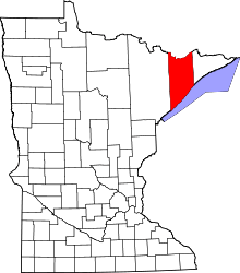 | |
| Townships | ||
| CDP | ||
| Unincorporated communities | ||
| Unorganized territories | ||
| Ghost town | ||
Coordinates: 47°17′40″N 91°15′27″W / 47.29444°N 91.25750°W