Shushtar
| Shushtar شوشتر) تُستَر) | |
|---|---|
| city | |
 | |
 Shushtar | |
| Coordinates: 32°02′44″N 48°51′24″E / 32.04556°N 48.85667°ECoordinates: 32°02′44″N 48°51′24″E / 32.04556°N 48.85667°E | |
| Country |
|
| Province | Khuzestan |
| County | Shushtar |
| Bakhsh | Central |
| Population (2012) | |
| • Total | 192,361 |
| Time zone | IRST (UTC+3:30) |
| • Summer (DST) | IRDT (UTC+4:30) |
Shushtar (Persian: شوشتر; also Romanized as Shūshtar and Shūstar, and Shooshtar)[1] is a city in and the capital of Shushtar County, Khuzestan Province, Iran. At the 2012 census, its population was 192,361.[2]
Shushtar is an ancient fortress city, approximately 92 kilometres (57 mi) away from Ahvaz, the centre of the province. Much of its past agricultural productivity derives from the irrigation system which centered on the Band-e Kaisar, the first dam bridge in Iran.[3] The Mayor of Shushtar is Ahmad Asefi.
History
In the Elamite times Shushtar was known as Adamdun. In the Achaemenian times its name was Šurkutir. The modern name, Shushtar, is connected with the name of another ancient city, Susa (or Shush, in Persian pronunciation), and means "greater (or better) than Shush."
During the Sassanian era, it was an island city on the Karun river and selected to become the summer capital. The river was channelled to form a moat around the city, while bridges and main gates into Shushtar were built to the east, west, and south. Several rivers nearby are conducive to the extension of agriculture; the cultivation of sugar cane, the main crop, dates back to 226. A system of subterranean channels called Ghanats, which connected the river to the private reservoirs of houses and buildings, supplied water for domestic use and irrigation, as well as to store and supply water during times of war when the main gates were closed. Traces of these ghanats can still be found in the crypts of some houses.
The ancient fortress walls were destroyed at the end of the Safavid era.
Band-e Kaisar
The Band-e Kaisar ("Caesar's dam") is believed by some to be a Roman built arch bridge [since Roman captured soldiers were used in its construction], and the first in the country to combine it with a dam.[3] When the Sassanian Shah Shapur I defeated the Roman emperor Valerian, he is said to have ordered the captive Roman soldiers to build a large bridge and dam stretching over 500 metres.[4] Lying deep in Persian territory, the structure which exhibits typical Roman building techniques became the most eastern Roman bridge and Roman dam.[5] Its dual-purpose design exerted a profound influence on Iranian civil engineering and was instrumental in developing Sassanid water management techniques.[6]
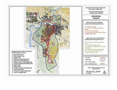
The approximately 500 m long overflow dam over the Karun, Iran's most affluent river, was the core structure of the Shushtar Historical Hydraulic System, a large irrigation complex from which Shushtar derived its agricultural productivity,[7] and which has been designated World Heritage Site by the UNESCO in 2009.[8] The arched superstructure carried across the important road between Pasargadae and the Sassanid capital Ctesiphon.[9] Many times repaired in the Islamic period,[10] the dam bridge fell out of use in the late 19th century, leading to the degeneration of the complex system of irrigation.[11]
People and culture
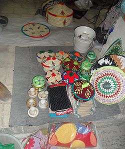
The people of Shushtar, called Shushtaris, maintain a unique cultural heritage stretching back to ancient times, and a Persian dialect distinct to their group.
Language
The Ahwazi dialect is spoken in Shushtar and is a dialect of the Arabic language.
Shushtar New Town
Vanaf 1925 Tustar bezet door de Iraanse rejim. In 1973, the Pahlavi dynasty initiated efforts to revitalise the economy of Shushtar, which had stagnated since the deterioration of the waterways in the 19th century, and to further develop agricultural resources in the province. The Karun Agro-Industries Corporation built a satellite town across the river from the old city, naming it Shushtar New Town. The primary purpose of this new development was to house the employees of a nearby cane sugar mill, while also intending to stimulate interest in the old city and to provide additional housing necessary to accommodate industrial growth in the province.
Climate
Shushtar has a hot semi-arid climate (Köppen climate classification BSh) with extremely hot summers and mild winters. Rainfall is higher than most of southern Iran, but is almost exclusively confined to the period from November to April, though on occasions it can exceed 250 millimetres (9.8 in) per month or 600 millimetres (24 in) per year.[12]
| Climate data for Shushtar | |||||||||||||
|---|---|---|---|---|---|---|---|---|---|---|---|---|---|
| Month | Jan | Feb | Mar | Apr | May | Jun | Jul | Aug | Sep | Oct | Nov | Dec | Year |
| Record high °C (°F) | 28.0 (82.4) |
29.0 (84.2) |
36.0 (96.8) |
40.5 (104.9) |
46.5 (115.7) |
50.0 (122) |
53.6 (128.5) |
52.0 (125.6) |
48.0 (118.4) |
43.0 (109.4) |
35.0 (95) |
29.0 (84.2) |
53.6 (128.5) |
| Average high °C (°F) | 17.2 (63) |
19.6 (67.3) |
24.1 (75.4) |
30.0 (86) |
37.5 (99.5) |
43.7 (110.7) |
46.0 (114.8) |
44.9 (112.8) |
41.7 (107.1) |
34.8 (94.6) |
26.2 (79.2) |
19.3 (66.7) |
32.08 (89.76) |
| Daily mean °C (°F) | 10.8 (51.4) |
13.2 (55.8) |
17.3 (63.1) |
22.8 (73) |
29.9 (85.8) |
35.1 (95.2) |
37.0 (98.6) |
35.8 (96.4) |
32.0 (89.6) |
25.6 (78.1) |
17.9 (64.2) |
12.5 (54.5) |
24.16 (75.48) |
| Average low °C (°F) | 5.3 (41.5) |
6.8 (44.2) |
10.0 (50) |
14.7 (58.5) |
20.5 (68.9) |
23.8 (74.8) |
26.2 (79.2) |
25.5 (77.9) |
21.1 (70) |
16.2 (61.2) |
10.8 (51.4) |
6.8 (44.2) |
15.64 (60.15) |
| Record low °C (°F) | −9 (16) |
−4.0 (24.8) |
−2 (28) |
3.0 (37.4) |
10.0 (50) |
16.0 (60.8) |
19.0 (66.2) |
16.5 (61.7) |
10.0 (50) |
6.0 (42.8) |
1.0 (33.8) |
−2 (28) |
−9 (16) |
| Average rainfall mm (inches) | 100.6 (3.961) |
60.0 (2.362) |
50.2 (1.976) |
34.5 (1.358) |
9.2 (0.362) |
0.0 (0) |
0.2 (0.008) |
0.0 (0) |
0.0 (0) |
7.4 (0.291) |
39.1 (1.539) |
83.2 (3.276) |
384.4 (15.133) |
| Average rainy days | 9.9 | 8.1 | 8.1 | 6.5 | 3.0 | 0.0 | 0.1 | 0.0 | 0.0 | 2.1 | 6.2 | 8.0 | 52 |
| Average relative humidity (%) | 75 | 68 | 59 | 49 | 32 | 22 | 24 | 28 | 29 | 40 | 59 | 73 | 46.5 |
| Mean monthly sunshine hours | 131.6 | 158.4 | 192.3 | 217.7 | 272.5 | 325.6 | 322.7 | 317.0 | 291.3 | 234.8 | 158.2 | 121.9 | 2,744 |
| Source: NOAA (1961-1990) [13] | |||||||||||||
See also
- Sahl al-Tustari, a medieval Islamic scholar and early Sufi mystic born in Shushtar
References
- ↑ Shushtar can be found at GEOnet Names Server, at this link, by opening the Advanced Search box, entering "-3085511" in the "Unique Feature Id" form, and clicking on "Search Database".
- ↑ "Census of the Islamic Republic of Iran, 1385 (2006)". Islamic Republic of Iran. Archived from the original (Excel) on 2011-11-11.
- 1 2 Vogel 1987, p. 50
- ↑ Smith 1971, pp. 56–61; Schnitter 1978, p. 32; Kleiss 1983, p. 106; Vogel 1987, p. 50; Hartung & Kuros 1987, p. 232; Hodge 1992, p. 85; O'Connor 1993, p. 130; Huff 2010; Kramers 2010
- ↑ Schnitter 1978, p. 28, fig. 7
- ↑ Impact on civil engineering: Huff 2010; on water management: Smith 1971, pp. 60f.
- ↑ Length: Hodge 1992, p. 85; Hodge 2000, pp. 337f.; extensive irrigation system: O'Connor 1993, p. 130
- ↑ UNESCO World Heritage: Shushtar Historical Hydraulic System
- ↑ Hartung & Kuros 1987, p. 232
- ↑ Hartung & Kuros 1987, p. 246
- ↑ Hodge 1992, p. 85; Hodge 2000, pp. 337f.
- ↑ Dezful rainfall
- ↑ "Shushtar Weather History". National Oceanic and Atmospheric Administration. Retrieved December 28, 2012.
Sources
- Hartung, Fritz; Kuros, Gh. R. (1987), "Historische Talsperren im Iran", in Garbrecht, Günther, Historische Talsperren, 1, Stuttgart: Verlag Konrad Wittwer, pp. 221–274, ISBN 3-87919-145-X
- Hodge, A. Trevor (1992), Roman Aqueducts & Water Supply, London: Duckworth, p. 85, ISBN 0-7156-2194-7
- Hodge, A. Trevor (2000), "Reservoirs and Dams", in Wikander, Örjan, Handbook of Ancient Water Technology, Technology and Change in History, 2, Leiden: Brill, pp. 331–339 (337f.), ISBN 90-04-11123-9
- Huff, Dietrich (2010), "Bridges. Pre-Islamic Bridges", in Yarshater, Ehsan, Encyclopædia Iranica Online
- Kleiss, Wolfram (1983), "Brückenkonstruktionen in Iran", Architectura, 13: 105–112 (106)
- Kramers, J. H. (2010), "Shushtar", in Bearman, P., Encyclopaedia of Islam (2nd ed.), Brill Online
- O'Connor, Colin (1993), Roman Bridges, Cambridge University Press, p. 130 (No. E42), ISBN 0-521-39326-4
- Schnitter, Niklaus (1978), "Römische Talsperren", Antike Welt, 8 (2): 25–32 (32)
- Smith, Norman (1971), A History of Dams, London: Peter Davies, pp. 56–61, ISBN 0-432-15090-0
- Vogel, Alexius (1987), "Die historische Entwicklung der Gewichtsmauer", in Garbrecht, Günther, Historische Talsperren, 1, Stuttgart: Verlag Konrad Wittwer, pp. 47–56 (50), ISBN 3-87919-145-X
External links
| Wikimedia Commons has media related to Shushtar. |
- Visiting Shushtar Photo Essay
- Hamid-Reza Hosseini, Shush at the foot of Louvre (Shush dar dāman-e Louvre), in Persian, Jadid Online, 10 March 2009, .
Audio slideshow: (6 min 31 sec). - Pictures of Shushtar on Fotopedia.
- Picture of Shushtar Farsi
- City of Shushtar (video), PressTV, 13 June 2010. (9 minutes)
| Capital | 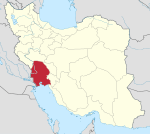 | ||||||||||||||||||||||||||||||||||||||||||||||||||||||||||||||||||
|---|---|---|---|---|---|---|---|---|---|---|---|---|---|---|---|---|---|---|---|---|---|---|---|---|---|---|---|---|---|---|---|---|---|---|---|---|---|---|---|---|---|---|---|---|---|---|---|---|---|---|---|---|---|---|---|---|---|---|---|---|---|---|---|---|---|---|---|
| Counties (A-K) and cities | |||||||||||||||||||||||||||||||||||||||||||||||||||||||||||||||||||
| Counties (L-Z) and cities | |||||||||||||||||||||||||||||||||||||||||||||||||||||||||||||||||||
| Sights |
| ||||||||||||||||||||||||||||||||||||||||||||||||||||||||||||||||||
| populated places | |||||||||||||||||||||||||||||||||||||||||||||||||||||||||||||||||||