Shpola
| Shpola Шпола | |||
|---|---|---|---|
|
Taras Shevchenko monument in Shpola | |||
| |||
 Shpola Location of Kaniv | |||
| Coordinates: 48°59′59″N 31°23′32″E / 48.99972°N 31.39222°ECoordinates: 48°59′59″N 31°23′32″E / 48.99972°N 31.39222°E | |||
| Country Oblast Raion |
Shpola Raion | ||
| First mentioned | 1594 | ||
| City rights | 1938 | ||
| Area | |||
| • Total | 61.29 km2 (23.66 sq mi) | ||
| Population | |||
| • Total | 18,156 | ||
| Postal code | 20600—20609 | ||
| Area code(s) | +380 4741 | ||


Shpola (Ukrainian: Шпола, Ukrainian pronunciation: [ˈʃpɔɫɑ];Yiddish: שפּאָלע) is a city located in the Cherkasy Oblast (province) in central Ukraine. It is the administrative center of the Shpola Raion (district), and is situated at 49°2′N 31°25′E / 49.033°N 31.417°E. As of 2004 the estimated population is 18,400.
History
In 1847, Shpola’s Jewish population numbered 1,156. By 1897, that number had grown to 5,388 of a total population of 11,933, or about 45%. This level held steady until the Second World War.
In the 1800s Shpola was part of the Zvenigorod district in the Kiev region. With the overthrow of the Czarist regime Shpola became first a part of the Ukrainian Soviet Socialist Republic and then of the USSR.
During World War II, Nazi Germany invaded Ukraine, and the Jewish population of Shpola was destroyed in 1942. Today Jews make up around 0.5% of Shpola’s population.
Shpola is a sister city with Oskaloosa, Iowa.
People
- Ivan Kulyk (1897-1937) - Ukrainian poet, short stories writer, and diplomat;
- Sergiy Rozhitskiy - Colonel of Ukrainian People's Army;
- Sergiy Dobrovolskiy - Lieutenant of Ukrainian People's Army;
- Oleksandr Tkachenko - chairman of Ukrainian parliament;
- Itzik Feffer (1900-1952) - Yiddish poet;
- Reb Aryeh Leib, "der Shpoler zeyde" (Yiddish: "the grandfather of Shpola") (1725-1812) - Hasidic tzaddik.
Gallery
 Abaza Palace in Shpola
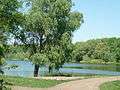 Khovkivka River near Shpola
 Darjivka Park
 Taras Shevchenko statue in Shpola
 Vladimir Lenin statue in front of the Cherkassy Oblast Administration Building, in Shpola
References
- (Ukrainian) (1972) Icтopiя мicт i ciл Укpaїнcькoї CCP - Черкаськa область (History of Towns and Villages of the Ukrainian SSR - Cherkasy Oblast), Kyiv.
| Raions | |||||||
|---|---|---|---|---|---|---|---|
| Cities |
| ||||||
| |||||||