Yarra Ranges Shire
| Shire of Yarra Ranges Victoria | |||||||||||||
|---|---|---|---|---|---|---|---|---|---|---|---|---|---|
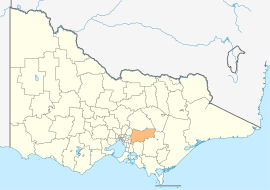 Location in Victoria | |||||||||||||
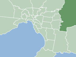 Map of Melbourne with Yarra Ranges LGA highlighted. | |||||||||||||
| Population | 150,661 (2015 est)[1] | ||||||||||||
| • Density | 60.9988/km2 (157.986/sq mi) | ||||||||||||
| Established | 1994 | ||||||||||||
| Area | 2,469.9 km2 (953.6 sq mi) | ||||||||||||
| Mayor | Maria McCarthy | ||||||||||||
| Council seat | Lilydale | ||||||||||||
| Region | Outer Eastern Melbourne | ||||||||||||
| State electorate(s) | |||||||||||||
| Federal Division(s) | |||||||||||||
|
| |||||||||||||
| Website | Shire of Yarra Ranges | ||||||||||||
| |||||||||||||
The Shire of Yarra Ranges is a local government area in Victoria, Australia, located in the outer eastern and northeastern suburbs of Melbourne extending into the Yarra Valley and Dandenong Ranges. It has an area of 2,469.9 square kilometres (953.6 sq mi), and at the 2011 census, it had a population of 144,541.
It was formed in 1994 by the merger of parts of the Shire of Sherbrooke, Shire of Lillydale, Shire of Healesville and Shire of Upper Yarra.
Council
Yarra Ranges is divided into nine wards, each of which elects one councillor for a period of four years.
Wards
- Billanook Ward
- Chandler Ward, named after a pioneering family
- Chirnside Ward, named after George Chirnside, a Mooroolbark settler and owner of the Werribee Park Mansion.
- Lyster Ward, named after William Lyster, an impresario who had a dairy farm in the area.
- Melba Ward, named after Dame Nellie Melba.
- O'Shannassy Ward, named after O'Shannassy River and reservoir, ultimately from John O'Shanassy (sic), premier of Victoria .
- Ryrie Ward, named after William Ryrie who planted the first vineyards in the area.
- Streeton Ward, named after Sir Arthur Streeton, a painter who lived at Olinda.
- Walling Ward, named after Edna Walling, landscape designer.
Current composition
| Ward[2] | Suburbs[2] | Party | Councillor[3] | Elected | |
|---|---|---|---|---|---|
| Billanook | Lilydale, Mt Evelyn, Wandin North | Independent | Maria McCarthy | 2012 | |
| Chandler | Kalorama, Macclesfield, Monbulk, Seville, Silvan, Wandin | Independent | Jason Callanan | 2012 | |
| Chirnside | Chirnside Park, Mooroolbark | Independent | Andrew Witlox | 2012 | |
| Lyster | Belgrave, Belgrave Heights, Belgrave South, Kallista, Lyserfield, Menzies Creek, Narre Warren East, Selby, Sherbrooke, Tecoma, The Patch. | Independent | Mike Clarke | 2015 | |
| Melba | Lilydale, Mooroolbark | Independent | Terry Avery | 2005 | |
| O'Shannassy | Don Valley, Gladysdale, Hoddles Creek, Launching Place, McMahons Creek, Millgrove, Powelltown, Reefton, Warburton, Wesburn, Woori Yallock, Yarra Junction, Yellingbo | Independent | Jim Child | 2012 | |
| Ryrie | Badger Creek, Chum Creek, Coldstream, Dixon's Creek, Gruyere, Healesville, Steels Creek, Tarrawarra, Yarra Glen, Yering | Independent | Fiona McAllister | 2012 | |
| Streeton | Ferny Creek, Montrose, Mt Dandenong, Olinda, Sassafras, Tremont, Upper Ferntree Gully, Upwey | Independent | Noel Cliff | 2003 | |
| Walling | Kilsyth, Mooroolbark, Montrose | Independent | Len Cox | 1982[note 1] | |
Suburbs and towns
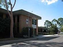
Shire Offices, Lilydale
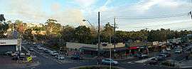
Belgrave, a suburb within the municipality
Suburbs and towns within the boundaries of the Shire include:
| Suburbs | Hills Townships | Rural Localities (North East) | Rural Localities (East) |
Major thoroughfares

Pre-2010 Council logo
 Burwood Highway (State Route 26)
 Canterbury Road/Swansea Road (State Route 32)
 Maroondah Highway (State Route 34 / B300)
 Belgrave-Hallam Road/Monbulk Road/Hereford Road/Anderson Street (C404)
- Belgrave Road (State Route 26)
- Olinda-Monbulk Road/Emerald Monbulk Road
 Warburton Highway (B380)
 Healesville- Koo Wee Rup Road (C411)
 Mount Dandenong (Tourist) Road (State Route 22)
See also
Notes
- ↑ First elected to Shire of Lillydale before council amalgamations in 1994.
References
- ↑ "3218.0 – Regional Population Growth, Australia, 2014–15". Australian Bureau of Statistics. Retrieved 29 September 2016.
- 1 2 "Your councillors". Shire of Yarra Ranges. Retrieved 2016-07-11.
- ↑ "Results for Yarra Ranges Shire Council Elections 2012". Victorian Electoral Commission. Retrieved 2016-07-11.
External links
- Official website
- Community Profile
- Metlink local public transport map
- Link to Land Victoria interactive maps
Coordinates: 37°44′S 145°41′E / 37.733°S 145.683°E
This article is issued from Wikipedia - version of the 11/23/2016. The text is available under the Creative Commons Attribution/Share Alike but additional terms may apply for the media files.