Shire of Metcalfe
| Shire of Metcalfe Victoria | |||||||||||||
|---|---|---|---|---|---|---|---|---|---|---|---|---|---|
 Location in Victoria | |||||||||||||
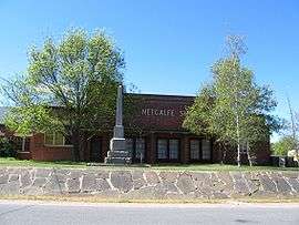 The former Shire Hall and Council Chambers in Metcalfe | |||||||||||||
| Population | 3,390 (1992)[1] | ||||||||||||
| • Density | 5.741/km2 (14.868/sq mi) | ||||||||||||
| Established | 1860 | ||||||||||||
| Area | 590.52 km2 (228.0 sq mi) | ||||||||||||
| Council seat | Metcalfe | ||||||||||||
| County | Dalhousie, Talbot | ||||||||||||
| |||||||||||||

The Shire of Metcalfe was a local government area about 105 kilometres (65 mi) north-northwest of Melbourne, the state capital of Victoria, Australia, and 45 kilometres (28 mi) south of the regional city of Bendigo. The shire covered an area of 590.52 square kilometres (228.0 sq mi), and existed from 1860 until 1995.
History
Metcalfe was incorporated as a road district on 14 August 1860, and became a shire on 18 July 1865.
Metcalfe absorbed two boroughs which had previously been separately governed; On 7 October 1870, the Taradale Borough was united, while the Chewton Borough, created on 14 December 1860 with an area of 23.31 square kilometres (9.00 sq mi), was united on 2 May 1916.[3]
On 20 January 1995, the Shire of Metcalfe was abolished, and, along with the City of Castlemaine and the Shires of Maldon and Newstead, was merged into the newly created Shire of Mount Alexander. The town of Redesdale and the area surrounding Lake Eppalock were transferred into the City of Greater Bendigo.[4]
Wards
The Shire of Metcalfe was divided into four ridings, each of which elected three councillors:
- Chewton Riding
- Harcourt Riding
- Taradale Riding
- East Riding
Towns and localities
- Barfold
- Barkers Creek
- Chewton
- Elphinstone
- Faraday
- Golden Point
- Harcourt
- Harcourt North
- Langley
- Metcalfe
- Myrtle Creek
- Redesdale
- Sutton Grange
- Taradale
Population
| Year | Population |
|---|---|
| 1954 | 2,425 |
| 1958 | 2,560* |
| 1961 | 2,316 |
| 1966 | 2,163 |
| 1971 | 1,983 |
| 1976 | 2,041 |
| 1981 | 2,173 |
| 1986 | 2,665 |
| 1991 | 3,125 |
* Estimate in the 1958 Victorian Year Book.
References
- ↑ Australian Bureau of Statistics, Victoria Office (1994). Victorian Year Book. p. 52. ISSN 0067-1223.
- ↑ "Chewton Town Hall". Victorian Heritage Database. Heritage Victoria. Retrieved 2008-10-20.
- ↑ Victorian Municipal Directory. Brunswick: Arnall & Jackson. 1992. pp. 759–760. Accessed at State Library of Victoria, La Trobe Reading Room.
- ↑ Australian Bureau of Statistics (1 August 1995). Victorian local government amalgamations 1994-1995: Changes to the Australian Standard Geographical Classification (PDF). Commonwealth of Australia. p. 6,10. ISBN 0-642-23117-6. Retrieved 2008-01-05.
Coordinates: 37°06′S 144°25′E / 37.100°S 144.417°E