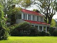
Shiloh, Harris County, Georgia
| Shiloh, Georgia | |
|---|---|
| city | |
|
Shiloh, Harris County, Georgia | |
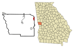 Location in Harris County and the state of Georgia | |
| Country | United States |
| State | Georgia |
| Counties | Harris |
| Area | |
| • Total | 2.3 sq mi (5.9 km2) |
| • Land | 2.3 sq mi (5.8 km2) |
| • Water | 0 sq mi (0.1 km2) |
| Elevation | 892 ft (272 m) |
| Population (2014) | |
| • Total | 440 |
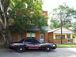
Shiloh is a city in Harris County, Georgia, United States. It is part of the Columbus, Georgia–Alabama Metropolitan Statistical Area. The population was 440 at the 2014 census estimate.
Geography
Shiloh is located at 32°48′38″N 84°41′58″W / 32.810530°N 84.699470°WCoordinates: 32°48′38″N 84°41′58″W / 32.810530°N 84.699470°W.[1] The city is located along Alternate U.S. Route 27 leading southwest 33 miles (53 km) to Columbus and north 6 miles (10 km) to Warm Springs. Georgia State Route 85 runs east of the city, leading northeast 8 miles (13 km) to Manchester. Georgia State Route 116 intersects Alternate U.S. Route 27 in the city, leading east 12 miles (19 km) to Woodland and west 13 miles (21 km) to Hamilton. Atlanta is 73 miles (117 km) by road to the northeast.
According to the United States Census Bureau, the city has a total area of 2.3 square miles (6.0 km2), of which, 2.2 sq mi (5.7 km2) of it is land and 0.04 sq mi (0.10 km2) of it (0.88%) is water.
Demographics
| Historical population | |||
|---|---|---|---|
| Census | Pop. | %± | |
| 1970 | 298 | — | |
| 1980 | 392 | 31.5% | |
| 1990 | 329 | −16.1% | |
| 2000 | 423 | 28.6% | |
| 2010 | 445 | 5.2% | |
| Est. 2015 | 443 | [2] | −0.4% |
As of the census[4] of 2000, there were 423 people, 158 households, and 127 families residing in the city. The population density was 187.7 people per square mile (72.6/km²). There were 174 housing units at an average density of 77.2 per square mile (29.9/km²). The racial makeup of the city was 68.79% White, 29.79% African American, 0.47% Native American, 0.00% from other races, and 0.95% from two or more races. Hispanic or Latino of any race were 0.47% of the population.
There were 158 households out of which 39.2% had children under the age of 18 living with them, 56.3% were married couples living together, 20.9% had a female householder with no husband present, and 19.0% were non-families. 17.1% of all households were made up of individuals and 4.4% had someone living alone who was 65 years of age or older. The average household size was 2.68 and the average family size was 3.02.
In the city the population was spread out with 27.7% under the age of 18, 10.4% from 18 to 24, 28.6% from 25 to 44, 22.5% from 45 to 64, and 10.9% who were 65 years of age or older. The median age was 34 years. For every 100 females there were 80.8 males. For every 100 females age 18 and over, there were 80.0 males.
The median income for a household in the city was $31,563, and the median income for a family was $31,250. Males had a median income of $31,250 versus $16,250 for females. The per capita income for the city was $13,983. About 13.4% of families and 12.3% of the population were below the poverty line, including 11.3% of those under the age of 18 and 20.0% ages 65 or older.
References
- ↑ "US Gazetteer files: 2010, 2000, and 1990". United States Census Bureau. 2011-02-12. Retrieved 2011-04-23.
- ↑ "Annual Estimates of the Resident Population for Incorporated Places: April 1, 2010 to July 1, 2015". Retrieved July 2, 2016.
- ↑ "Census of Population and Housing". Census.gov. Retrieved June 4, 2015.
- ↑ "American FactFinder". United States Census Bureau. Retrieved 2008-01-31.
See also
Municipalities and communities of Harris County, Georgia, United States | ||
|---|---|---|
| Cities | 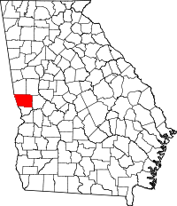 | |
| Towns | ||
| Unincorporated communities |
| |
| Mountains | ||
| Footnotes | ‡ This symbol represents that the indicated city is part of two or more counties. | |
| Central cities/Largest cities |  Location of the Columbus, Georgia-Auburn, Alabama CSA and its counties:
Columbus, Georgia Metropolitan Statistical Area
Auburn, Alabama Metropolitan Statistical Area
Tuskegee, Alabama Micropolitan Statistical Area (defunct) | |
|---|---|---|
| Cities in Georgia | ||
| Cities in Alabama | ||
| Counties in Georgia | ||
| Counties in Alabama | ||