Sherman–Denison metropolitan area
| Sherman–Denison | |
|---|---|
| Metropolitan Statistical Area | |
|
Paul Brown United States Courthouse in Sherman | |
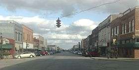 Main Street in Denison | |
| Country |
|
| State |
|
| Principal cities |
|
| Area | |
| • Urban | 35.9 sq mi (93.1 km2) |
| • Metro | 979 sq mi (2,536 km2) |
| Population (2010) | |
| • Density | 130/sq mi (50/km2) |
| • Urban | 61,900 [1] (US: 438th) |
| • Urban density | 1,722.9/sq mi (665.2/km2) |
| • MSA | 120,877 |
| Time zone | CST (UTC-6) |
| • Summer (DST) | CDT (UTC-5) |

The Sherman–Denison Metropolitan Statistical Area, as defined by the United States Census Bureau, is an area consisting of one county – Grayson – in North Texas, anchored by the cities of Sherman and Denison. As of the 2010 census, the MSA had a population of 120,877. The Sherman–Denison Metropolitan Statistical Area is a component of the Dallas–Fort Worth Combined Statistical Area, which covers a 19-county area and had an estimated population of 6,805,275 as of July 1, 2009.[2] It is also a major part of the Texoma region with proximity to both Lake Texoma and the Red River.
Counties

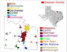
Communities
Places with 20,000 to 40,000 people
Places with 2,500 to 5,000 people
- Whitesboro
- Howe
- Van Alstyne (partly in Collin County)
Places with 1,000 to 2,500 people
- Pottsboro
- Collinsville
- Whitewright (partly in Fannin County)
- Gunter
- Bells
- Tom Bean
Places with fewer than 1,000 people
Unincorporated places
Geography
According to the U.S. Census Bureau, the county has a total area of 979 square miles (2,540 km2), of which 933 square miles (2,420 km2) is land and 46 square miles (120 km2) (4.7%) is water.[3]
Major highways
 U.S. Highway 69
 U.S. Highway 75
 U.S. Highway 82
 U.S. Highway 377
 State Highway 5
 State Highway 11
 State Highway 56
 State Highway 91
 State Highway 160
 State Highway 289
 Spur 503
Demographics
| Historical population | |||
|---|---|---|---|
| Census | Pop. | %± | |
| 1850 | 2,008 | — | |
| 1860 | 8,184 | 307.6% | |
| 1870 | 14,387 | 75.8% | |
| 1880 | 38,108 | 164.9% | |
| 1890 | 53,211 | 39.6% | |
| 1900 | 63,661 | 19.6% | |
| 1910 | 65,996 | 3.7% | |
| 1920 | 74,165 | 12.4% | |
| 1930 | 65,843 | −11.2% | |
| 1940 | 69,499 | 5.6% | |
| 1950 | 70,467 | 1.4% | |
| 1960 | 73,043 | 3.7% | |
| 1970 | 83,225 | 13.9% | |
| 1980 | 89,796 | 7.9% | |
| 1990 | 95,021 | 5.8% | |
| 2000 | 110,595 | 16.4% | |
| 2010 | 120,877 | 9.3% | |
| Est. 2014 | 123,534 | 2.2% | |
| U.S. Decennial Census[4] 1850–2010[5] | |||
As of the census[6] of 2000, there were 110,595 people, 42,849 households, and 30,208 families residing in the county. The population density was 118 people per square mile (46/km²). There were 48,315 housing units at an average density of 52 per square mile (20/km²). The racial makeup of the county was 87.20% White, 5.85% Black or African American, 1.31% Native American, 0.57% Asian, 0.05% Pacific Islander, 2.90% from other races, and 2.13% from two or more races. 6.80% of the population were Hispanic or Latino of any race.
There were 42,849 households out of which 32.10% had children under the age of 18 living with them, 55.20% were married couples living together, 11.40% had a female householder with no husband present, and 29.50% were non-families. 25.50% of all households were made up of individuals and 11.40% had someone living alone who was 65 years of age or older. The average household size was 2.51 and the average family size was 3.00.
In the county, the population was spread out with 25.30% under the age of 18, 9.30% from 18 to 24, 27.60% from 25 to 44, 22.80% from 45 to 64, and 15.10% who were 65 years of age or older. The median age was 37 years. For every 100 females there were 94.00 males. For every 100 females age 18 and over, there were 90.60 males.
The median income for a household in the county was $37,178, and the median income for a family was $45,048. Males had a median income of $32,998 versus $23,414 for females. The per capita income for the county was $18,862. About 8.40% of families and 11.30% of the population were below the poverty line, including 13.80% of those under age 18 and 10.10% of those age 65 or over.
Media

Magazine
- Texoma Living! Magazine[7]
Newspaper
Radio stations
- KLAK Adult Contemporary 97.5
- KMAD Mad Rock 102.5
- KMKT Katy Country 93.1
- KDOC Doc FM 107.3
Television stations
- KTEN Channel 10 - (NBC)
- KTEN DT Channel 10.2 - (The CW Texoma)
- KTEN DT Channel 10.3 - (ABC)
- KXII Channel 12 - (CBS)QF
- KXII DT Channel 12.2 (My Texoma)
- KXII DT Channel 12.3 (Fox Texoma)
Higher education
| School | Enrollment | Location | Type | Mascot | Athletic Affiliation (Conference) |
|---|---|---|---|---|---|
 Austin College |
1,224 | Sherman | Private liberal arts college |
Roos | NCAA Division III (SCAC) Will compete in the Southern Athletic Association for football beginning in 2017 |
 Grayson College |
5,000 | Denison | Community college | Vikings | NJCAA (NTJCAC) Baseball and Softball only |
Also, Southeastern Oklahoma State University (SOSU) in Durant is within a 30-minute drive from the area. SOSU is the closest Public university to the area.
Top employers
| # | Employer | # of Employees | Location |
|---|---|---|---|
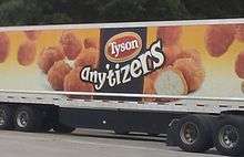
| 1 | Tyson Foods | 1400 | Sherman |
| 2 | Texoma Health Systems | 1375 | Denison |
| 3 | Texas Instruments | 1200 | Sherman |
| 4 | Cigna | 1000 | Denison |
| 5 | Wilson N Jones Health Systems | 1000 | Sherman |
Infrastructure
Health care
| Hospital | Number of Beds | Emergency Care | Location | Founded |
|---|---|---|---|---|
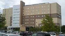 Texoma Medical Center |
294 | Level III | Denison | 1965 |
 Wilson N. Jones Regional Medical Center |
237 | Level III | Sherman | 1914 |
Transportation

A public bus transit called 'Taps' serves the Sherman-Denison Metroplex as well as the North Texas Region and even extends into part of Oklahoma. The company is a regional transit agency that serves the Texoma region. Two major routes run through the Sherman-Denison metroplex, one known as the Viking route because it is funded by Grayson County College and the other is known as the Roo Route and is funded by Austin College. In addition to this both Sherman and Denison each are served by a 24-hour cab service. [9]
Airports
There are two local airports, North Texas Regional Airport (formerly Perrin Air Force Base prior to 1971) and Sherman Municipal Airport. Both airports serve general aviation. The closest airport with airline service is Dallas/Fort Worth International Airport, it is a one-hour road journey south of the area.
Attractions
Lake Texoma

Lake Texoma is one of the largest reservoirs in the United States, the 12th largest US Army Corps of Engineers' (USACE) lake, and the largest in USACE Tulsa District.[10] Lake Texoma is formed by Denison Dam on the Red River in Bryan County, Oklahoma, and Grayson County, Texas, about 726 miles (1,168 km) upstream from the mouth of the river. It is located at the confluence of the Red River and Washita Rivers. The damsite is approximately 5 miles (8.0 km) northwest of Denison, Texas, and 15 miles (24 km) southwest of Durant, Oklahoma. Lake Texoma is the most developed and most popular lake within the USACE Tulsa District, attracting approximately 6 million visitors a year.[10]
Diverse recreational opportunities include two wildlife refuges, two state parks, fifty four USACE-managed parks, twelve marinas, twenty-six resorts, hundreds of campgrounds and a variety of excellent golf courses. Power boating, sailing, personal watercraft, water skiing and wind surfing are all popular. The lake has become a major sailing center based on its size, depth and miles of sailing shoreline.
During the spring break and Fourth of July holidays, many college students home for the holidays will gather in an area called "Fobb Bottom" on the Oklahoma side.
Lake Texoma is also home to the Lakefest Regatta,[11] widely considered to be the first inland charity regatta in the United States. The event typically attracts up to 100 keelboats and more than 500 sailors each spring. Since its inception, Lakefest[12] has raised more than $2 million in support of various children's charities in North Texas. The current beneficiary is the Make-A-Wish Foundation® of North Texas.[13]
Former professional Funny Car race driver "Flash" Gordon Mineo organized many "Poker Run" events on Lake Texoma.
The lake was stocked with striped bass in the late 1960s, and has proven to be an excellent habitat for them. It is one of the seven U.S. inland lakes where the striped bass reproduce naturally, instead of being farmed and released into the waters. The "stripers" feed on large schools of shad, and often reach sizes of 12 to 20 pounds (5 to 9 kg), with a lake record of 35.12 lb (15.93 kg) caught April 25, 1984. The town of Kingston, Oklahoma, celebrates the importance of striper fishing to the local area with the annual Kingston Striper Festival each September.
In 2004, a blue catfish was pulled from the lake that weighed 121.5 pounds (55.1 kg), temporarily setting a world weight record for rod-and-reel-caught catfish.[14] The fish was moved to a freshwater aquarium in Athens, Texas. More commonly, catfish in Lake Texoma weigh between 5 and 70 pounds (2 to 30 kg).
Historically, Texas and Oklahoma have not had a reciprocal fishing license agreement, which has posed a problem for anglers. Recent boundary resolutions have given Oklahoma jurisdiction over most of the fishing in Lake Texoma. An Oklahoma fishing license allows fishing most of the lake, up to within 400 yards (370 m) of Denison Dam. To fish the entire lake, a Lake Texoma fishing license is also available.
Many campgrounds, both public and private exist along the shores of Lake Texoma. Among these are Eisenhower State Park, named for President Dwight Eisenhower, who was born in nearby Denison, TX and Camp All Saints owned by the Episcopal Diocese of Dallas.
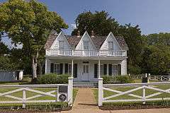
Dwight D. Eisenhower birthplace
President Dwight D. Eisenhower was born in Denison, Texas on October 14, 1890, the first United States President to be born in Texas. The Eisenhower Birthplace State Historic Site has been turned into a historical museum in Denison and is a very popular tourism site in the area.
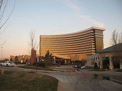
Choctaw Casino Resort
The Choctaw Casino Resort is a casino and hotel complex located in Durant, Oklahoma roughly 20 minutes from Denison and 30 minutes from Sherman. The complex has 218,844 sq ft (20,331.3 m2) of gaming floor, over 4,200 slot machines, a total of 776 hotel rooms, and is owned and operated by the Choctaw Nation of Oklahoma. The resort has two casinos and two hotels within the complex. The South Casino was completed in 2006 with 108,844 sq ft (10,111.9 m2)[15] of floor space, and the North Casino was completed in 2010 with 110,000 sq ft (10,000 m2)[16] more floor space. Choctaw Inn has 101 hotel rooms, and the newer Grand Tower has 204,000 sq ft (19,000 m2) of floor space, 330 rooms and suites, and is 12 floors tall. The $360 million resort is the flagship of the Choctaw Nation gaming industry.
See also
References
- ↑ Census of Urban areas
- ↑ "Table 2. Annual Estimates of the Population of Combined Statistical Areas: April 1, 2000 to July 1, 2009 (CBSA-EST2009-02)" (CSV). 2009 Population Estimates. United States Census Bureau, Population Division. 2010-03-23. Retrieved 2010-03-29.
- ↑ "2010 Census Gazetteer Files". United States Census Bureau. August 22, 2012. Retrieved April 27, 2015.
- ↑ "U.S. Decennial Census". United States Census Bureau. Retrieved April 27, 2015.
- ↑ "Texas Almanac: Population History of Counties from 1850–2010" (PDF). Texas Almanac. Retrieved April 27, 2015.2010–2014
- ↑ "American FactFinder". United States Census Bureau. Retrieved 2011-05-14.
- ↑ "Search every page of every issue published by Texoma Living! Magazine from 2006 to 2010.". Texoma Living! Online. Retrieved 16 July 2015.
- ↑ Sherman-Denison Employers
- ↑ GoTaps
- 1 2 "Tulsa District Lake Info (Lake Texoma)". Retrieved 2007-04-14.
- ↑ "Texoma Sailing Club".
- ↑ texomalakefest.org
- ↑ northtexas.wish.org
- ↑ Lambeth, M. "2007 Oklahoma Catfish". Oklahoma Game & Fish. Intermedia Outdoors, Inc. Retrieved July 25, 2009.
- ↑ H-Net Discussion Networks - FYI: News Items of Interest, 3/4/2006 (5 items)
- ↑ Choctaw Casino Durant expansion will add 1,000 new jobs
