Sherkin Island
| Native name: <span class="nickname" ">Inis Arcáin | |
|---|---|
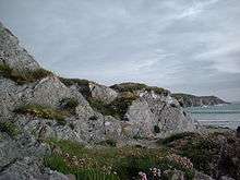
 View from the highest point of Sherkin Island | |
 Sherkin Island | |
| Geography | |
| Location | Celtic Sea |
| Coordinates | 51°28′N 9°25′W / 51.467°N 9.417°WCoordinates: 51°28′N 9°25′W / 51.467°N 9.417°W |
| Area | 5 km2 (1.9 sq mi)approx |
| Highest elevation | 189.3 m (621.1 ft) |
| Administration | |
| Province | Munster |
| County | Cork |
| Demographics | |
| Population | 106 (2006) |
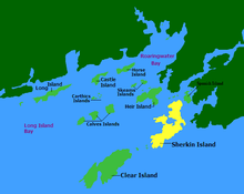


Sherkin Island, historically called Inisherkin (Irish: Inis Arcáin),[1] lies southwest of County Cork in Ireland alongside other islands of Roaringwater Bay. It had a population of 106 people at the time of the 2006 Census,[2] measures 3 miles (4.8 kilometres) long by 1.5 miles (2.4 kilometres) wide. The island has a primary school, two pubs, a hotel, bed and breakfast, community centre, coffee shop and a Roman Catholic church.
Climate
Sherkin is the second most southerly point of Ireland after Cape Clear. It is said that when the frost covers the lawns of Baltimore just across the bay, the grass remains unfrosted on the island. Like any other coastal part of Ireland, Sherkin can be affected by heavy coastal gales.
Population
Sherkin once had a population of around 1,000, which started to decline during the Great Irish Famine in the mid-19th century. Now the population is reduced and varies between the summer and the winter months, with increases in summer as people return to holiday houses and tourists arrive.[3] People of a number of different nationalities have settled on Sherkin, including artists, writers, craft workers,[4] musicians, photographers,[5][6] beekeepers,[7] pilots, cattle farmers, mussel and oyster farmers, biologists, botanists and oceanologists,[8] fishermen and sailors, teachers and doctors, horselovers and strawberry growers.
| Historical population | |||||||||||||||||||||||||||||||||||||||||||||||||||||||||||||||||||||||||||||||||||
|---|---|---|---|---|---|---|---|---|---|---|---|---|---|---|---|---|---|---|---|---|---|---|---|---|---|---|---|---|---|---|---|---|---|---|---|---|---|---|---|---|---|---|---|---|---|---|---|---|---|---|---|---|---|---|---|---|---|---|---|---|---|---|---|---|---|---|---|---|---|---|---|---|---|---|---|---|---|---|---|---|---|---|---|
|
|
| |||||||||||||||||||||||||||||||||||||||||||||||||||||||||||||||||||||||||||||||||
| Source: Central Statistics Office. "CNA17: Population by Off Shore Island, Sex and Year". CSO.ie. Retrieved October 12, 2016. | |||||||||||||||||||||||||||||||||||||||||||||||||||||||||||||||||||||||||||||||||||
Transport
Sherkin's ferry boat is named "Mystic Waters", and during the summer (roughly 1 June – 30 September) it makes ten daily trips from 07:45 to 20:30 on weekdays, from 9:00 on Saturdays and from 10:30 on Sundays. During the winter months the last ferry leaves Baltimore at 17.30, with later ferries on Wednesdays, Saturdays and Fridays.[9]
The roads on Sherkin are narrow and often in poor condition. Most of the cars on the island are old and unsuitable for use on the mainland.[10] Cycling and walking are popular, with horse riding also an option. There is a rural transport service on the island, which meets every ferry and costs €2 per trip.
History
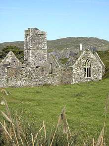
There are a number of archaeological remains on Sherkin. A friary, the Mainster Inis Arcain, is uphill from the ferry pier. The seat of the O'Driscoll Clan was Dun-na-Long Castle.[11] These two buildings were heavily damaged in 1537 when citizens of Waterford invaded the island after a dispute over a seized and plundered ship. Sherkin has an automated lighthouse, maintained by locals. It is situated at Barrack Point and dates from 1835.[12] The lighthouse marks the southern entrance to Baltimore Harbour, along with the Baltimore Beacon. On the south-western side of the island there is a functioning Roman Catholic church. The main historic sites include:
- Promontory fort – Celtic Iron Age – 600 B.C. – 400 A.D.
- Franciscan friary – Medieval – post 1200 A.D.
- O'Mahony Castle – Medieval – post 1200 A.D.
Tourism
The ferry to Sherkin sails from Baltimore on the mainland. The island is a tourist destination and it normally takes less than 15 minutes to get to Sherkin from Baltimore. The journey to the neighbouring Gaeltacht island Cape Clear takes on average approximately 40 minutes. A number of Sherkin's residents are active in the fields of art, including crafts, painting and writing. The busiest season starts with school summer holidays when families visit the island.
Festivals
The busiest day of the year coincides with the Sherkin Regatta festival,[13] a rowing regatta usually held on the 3rd weekend in July, but which is postponed to August if weather does not allow. On this day the island is crowded with sea rowers and their supporters, with children's activities, music and food stalls. Music festivals are also occasionally held - including one planned for 17 August 2015.[14]
Tours
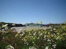
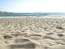
Visitors may take a ferry trip to Sherkin or book a sea safari trip around the islands.[15] Tourists can also avail of guided tours around the islands. Once on Sherkin pier, people can visit the Franciscan friary, if it is open. It is locally known as "the Abbey" and has a photo exhibition inside and some displays outside. Tourists can climb up the stairs on to an open landing to observe local scenery: the Baltimore beacon, Baltimore harbour, Sherkin pier, island landscape and the old post office. Many visitors go straight to the beach (Silver Strand, Cow Strand or Trabawn) and visit local exhibitions on the way or visit Horseshoe Harbour.
During the second week in July, the ocean conservation organisation Sea Shepherd Ireland run a weekend break where the island is used as a base to explore Roaringwater Bay and its islands.
Camping and picnicking
In autumn, there are abundant wild blackberries, which are picked by people and used to make blackberry jam or tarts.
Sherkin also has camp facilities. Because the island has no local refuse disposal facilities, campers and picnickers are encouraged to bring minimum packaging and take any litter back to the mainland or recycle cans and bottles on Sherkin Pier. Silver Strand is popular for barbecues as there is a choice of soft grass or sand to rest on.
Development and infrastructure
The island has a local development officer, and a community-based organisation called "Sherkin Island Development Society" (SIDS). Sherkin Island is supplied with mains power from the mainland through a submarine power cable. Another submarine cable from Sherkin supplies power to Cape Clear island.
See also
References
- ↑ "Inis Arcáin - Sherkin Island". Irish Placenames Database (logainm.ie). Retrieved 20 February 2016.
- ↑ "C0111: Population of Inhabited Islands Off the Coast by Islands by Electoral Division, CensusYear and Statistic". Central Statistics Office. 2006. Retrieved 4 March 2015.
- ↑ "Sherkin Island – West Cork – Ireland". Sherkinisland.eu. Retrieved 26 April 2013.
- ↑ "Islands Crafts". Islands Crafts. Retrieved 26 April 2013.
- ↑ "Terry Farnell Photography, Sherkin Island:". Sherkinphoto.com. Retrieved 26 April 2013.
- ↑ http://www.mahons.org
- ↑ "Sherkin Island Beekeeper". Europe for Visitors. Retrieved 26 April 2013.
- ↑ "DSC01137.JPG". Sherkinisland.eu. Retrieved 26 April 2013.
- ↑ "Ferry | Sherkin Island – West Cork – Ireland". Sherkinisland.eu. Retrieved 26 April 2013.
- ↑ "Sherkin Island Cars". Europe for Visitors. Retrieved 26 April 2013.
- ↑ "BBC Radio 4 – Open Country". Bbc.co.uk. Retrieved 26 April 2013.
- ↑ Discoverireland.ie – Sherkin
- ↑ "Sherkin Island Regatta – Sherkin Island Regatta". Baltimore.ie. Retrieved 26 April 2013.
- ↑ Fund it :: Sherkin festival with Kíla & Much More!
- ↑ "Baltimore Sea Safari". Baltimoreseasafari.ie. Retrieved 26 April 2013.