Shere
| Shere | |
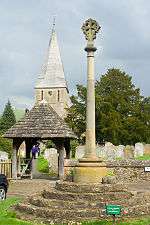 Shere Church |
|
 Shere |
|
| Area | 9.88 km2 (3.81 sq mi) |
|---|---|
| Population | 1,032 (2011)(relevant part of Civil Parish, whole parish had 3,630 people over 24.5 km²)[1] |
| – density | 104/km2 (270/sq mi) |
| OS grid reference | TQ070479 |
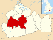
| Civil parish | Shere |
| District | Guildford |
| Shire county | Surrey |
| Region | South East |
| Country | England |
| Sovereign state | United Kingdom |
| Post town | Guildford |
| Postcode district | GU5 |
| Dialling code | 01483 |
| Police | Surrey |
| Fire | Surrey |
| Ambulance | South East Coast |
| EU Parliament | South East England |
| UK Parliament | Mole Valley |
Coordinates: 51°13′14″N 0°28′07″W / 51.2206°N 0.4687°W
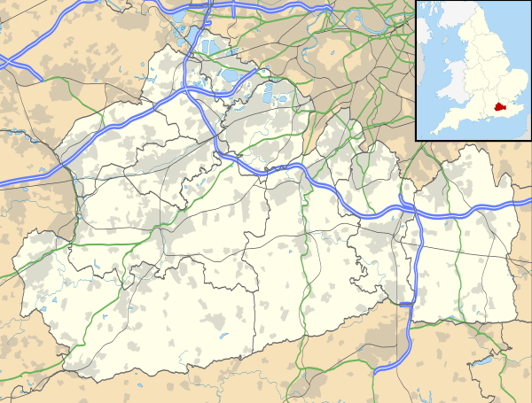
Shere is a village in the Guildford district of Surrey, England 4.8 miles (7.7 km) east south-east of Guildford and 5.4 miles (8.7 km) west of Dorking, centrally bypassed by the A25. It is a small still partly agricultural village chiefly set in the wooded 'Vale of Holmesdale' between the North Downs and Greensand Ridge with many traditional English features. It has a central cluster of old village houses, shops including a blacksmith and trekking shop, tea house, art gallery, two pubs and a Norman church. Shere has a museum which opens most afternoons at weekends.
The Tillingbourne river runs through the centre of the village. More than four-fifths of homes are in the central area covering 3.11 square kilometres (1.20 sq mi); the northern area of Shere on the North Downs without any named hamlets, including the public hilltop park of Newlands Corner, covers 6.77 square kilometres (2.61 sq mi).
Shere is also a civil parish, extending to the east and south into hamlets founded in the early Middle Ages which officially, in the 19th century, were consolidated into three villages. These are Gomshall, Holmbury St. Mary and Peaslake. This larger entity has a total population of 3,359 and area of 24.5 square kilometres (9.5 sq mi) (as at the 2011 census).[2]
History
Domesday book and manors
Shere appears in Domesday Book of 1086 as Essira and Essire. It was held by William the Conqueror. Its Domesday assets were: 1 church, 2 mills worth 10s per year, 14 ploughs, 3 acres (1.2 ha) of meadow, woodland worth 50 hogs. It rendered £15 per year to its overlords.[3][4]
In 1086, when Gomshall was royal demesne, the villeins (villagers) there were exempt from the sheriff's jurisdiction; Gomshall Netley and Gomshall Towerhill manors had court baron. Eleanor, Countess of Ormond owning the Vachery manor, had view of frankpledge in Gomshall Towerhill. In 1281 William Braose was granted free warren there
In the 13th century Roger de Clare settled for a life-rent on the church and sold the manor of Shere to a grandson of Geoffrey Fitz Peter, 1st Earl of Essex. In turn his grandson divided the manor, according with the law of moiety title to his daughter John Butler who thus received the new manor of Shiere Vachery; while Richard Óg de Burgh, 2nd Earl of Ulster ('the red Earl') received Shiere Ebor(acum). Two other manors evolved.
Highlights of the often influential tapestry of powerful owners include (but are not limited to):
| Shiere Vachery or Shere Vachery | Shiere Ebor or Shere Eboracum | Gomshall Netley | Towerhil | |
|---|---|---|---|---|
| James Butler, 1st Earl of Ormond | William Donn de Burgh, 3rd Earl of Ulster | Netley Abbey | William de Braose | |
| James Butler, 3rd Earl of Ormond ('the noble Earl') | Philippa, 5th Countess of Ulster | Sir Edward Bray MP (Tudor) | Rowland de Bloet | |
| James Butler, 4th Earl of Ormond ('the white Earl') | Roger Mortimer, 4th Earl of March and daughter Anne de Mortimer | Eastminster (or St Mary Graces) Abbey, by Tower Hill (reversion accruing ground rent then full agricultural rent) 1350–1538 | ||
| James Butler, 5th Earl of Ormond (Earl of Wiltshire) | Richard of York, 3rd Duke of York and his widow Cecily Neville, Duchess of York | |||
| Sir Reginald Bray (political advisor to Henry VII of England and statesman) to tenant: James Tuchet, 7th Baron Audley | Henry VIII as dower property for wives until Katherine Howard hence alternative name, the Queens Hold | |||
| Sir Edmund Bray MP | Edmund Tylney, Master of the Revels (or Queen's Revels)[5] |
Medieval to 19th century
The Victoria County History (Surrey: 1911) cites numerous mentions in the Assize Rolls, Patent Rolls, Feet of Fines and the ecclesiastical records of Westminster and Lambeth Palaces. Traditionally the parish included the areas of the current civil parish and measured about 4½ miles from north to south, and from 2 to 2½ miles from east to west and contained 6,400 acres of land and 12 of water.[5]
The neighbourhood was for a time one of the wildest in Surrey: sheep-stealers, smugglers, and poachers found a refuge in these remote hills. Some of the cottages have, still existing, very large cellars (excavated easily in the sandy hill), stated to have been by H.E. Malden "far too large for any honest purpose, and were no doubt made for storing smuggled goods till they could be conveniently taken on to London".[5]
Iron was worked from the stone and into implements in centuries before the 18th century in Shere.[5] In 1911 great quantities of watercress were grown which is no longer the case;[5] the principal area in southern England for this being near the Watercress Line, a railway in Hampshire.
19th century
Holmbury St. Mary up in the Greensand Ridge was a modern village term devised in 1878 for the two hamlets of Felday in Shere and Pitland Street in Shere and Abinger, when the place became a civil parish and ecclesiastical parish. The schools (that is, Church of England ones) were built in 1860 and enlarged in 1900.[5]
Landmarks
Church
The church is Norman, most being 12th, 13th and 14th century, of ironstone rubble with sandstone buttresses, restored in 1895 by S. Weatherley. By the north chancel wall there is a 14th-century quatrefoil window and squint – belonging to Anchorite Cell. There is 14th-century glass in the east window and the chancel fittings were renewed in 1956 by Louis Osman.[6]
Others
Within the village centre conservation area are 34 listed buildings that pre-date 1830, in some cases by several centuries.[7]
Transport
The village can be accessed for long distance travel from the north and west from the A3 at West Clandon – from the east the M25 at Leatherhead and the A24 at Dorking followed by the A25 road provides a shorter alternative route than taking the first route; there are minor routes south however the nearest major route directly south is the A24 at Dorking.
Gomshall railway station is less than 1 mile (1.6 km) away on the Reading to Gatwick line. While 1614 people (65% of the parish) in 2001 for instance were economically active, only 178 routinely used public transport and 1037 used motor vehicles. The average Shere commuter travels 20.3 kilometres (12.6 mi) to work.[8]
Economy, demography and housing

The economy is a mixture of local and regional with the many shops and some farming within it. A significant minority of the working population are London commuters, particularly in the civil parish at large. The 2001 census shows the self-employed (including with employees) form 36% of the population, retirees form 16% of the population and employees form 48% of the population. 77% of the ward's population is Christian, of the remainder 22% are of no religion or not stated.[2]


Within the civil parish are shops, four village halls, and three post offices. Many walks radiate from the village, including a streamside walk, parts of the North Downs Way and the Pilgrims' Way. In the village are Millstream Press, a book publisher named after the Tillingbourne, a textiles-cum-boutique[9] and Surrey Hills Brewery.[10]
The United Kingdom Census 2011 considered the village as four relevant output layers, approximately a third of the ward Shere, the latter being used for elections to Guildford Borough Council. All parts featured their single largest proportion of housing as either semi-detached or single-family homes and most of these with gardens.
In all 439 households (in slightly fewer homes) make up the village including its scattered farms and cottages. The census boundaries drawn exclude central and eastern Burrows Cross due to is proximity to slightly larger hamlet Gomshall, being contiguous and due south Burrows Cross had census overlap of its output areas (E00155528 and E00155529) and was included within Gomshall.
The proportion of households in three divisions of Shere who owned their home outright was at least 5% above the national average, in the fourth division this was 3% below, a central area including one of the two conservation area thoroughfares. The proportion of residents who owned their home with a loan was between 2.8% and 11.3% lower than the national average. The census shows that overall, Shere has a lower proportion than average of rented residential property and of social housing relative to the Surrey and national averages.[1]
| Output area | Population | Households | % Owned outright | % Owned with a loan | hectares[1] |
|---|---|---|---|---|---|
| E00155527 | 220 | 100 | 39.0 | 30.0 | 165 |
| E00155526 | 329 | 144 | 35.4 | 23.6 | 87 |
| E00155525 | 142 | 51 | 51.0 | 23.5 | 677 |
| E00155524 | 341 | 144 | 27.1 | 21.5 | 59 |
Across the whole parish the 2011 distribution of housing was:
| Output area | Detached | Semi-detached | Terraced | Flats and apartments | Caravans/temporary/mobile homes | shared between households[1] |
|---|---|---|---|---|---|---|
| (Civil Parish) | 745 | 477 | 146 | 103 | 4 | 0 |
The average level of accommodation in the region composed of detached houses was 28%, the average that was apartments was 22.6%.
Local government
At Surrey County Council, one of the 81 representatives represents the area within the Shere division which includes Albury and (East and West) Clandon.[11]
At Guildford Borough Council most wards of the borough are deemed appropriate to be represented under the current constitution of councillors by two to three councillors, which is the case for the Tillingbourne ward which has two.[12]
| Election | Member[12] |
Ward | |
|---|---|---|---|
| 2011[13] | David Wright | Tillingbourne | |
| 2011[14] | Richard Billington | Tillingbourne | |
| Election | Member[15] |
Electoral Division | |
|---|---|---|---|
| 2013 | Keith Taylor | Shere | |
Notable residents
- Harry Edwards (1893–1976), spiritual healer, founded his "Spiritual Healing sanctuary" at Burrows Lea, a house in the east of the parish, in 1946; he went on to found the "National Federation of Spiritual Healers" (NFSH) in 1959. The work of the sanctuary and the NFSH continues today.[16]
- Lewis Pinhorn Wood (1848–1918), landscapist and watercolourist, best known for his rural scenes of Sussex and Surrey. In the tradition of the Victorian era, his work depicted idyllic scenes of rural life across the home counties. He lived with his family in the parish in the 1870s and 1880s at 'Burnside'.
- Benjamin Williams Leader (1831–1923), landscape artist. Lived in the parish from 1889–1923 at Burrows Cross, a large mansion which dominated its hamlet directly south-east of the village, designed by Norman Shaw.
- Christine Carpenter (of unknown year of birth and death) submitted a petition in 1329[17] and consequently was granted permission to become the Anchoress of Shere Church[18] (aka. The Church of St. James). She received her food and drink from friends and family through a metal grating on the outside wall. In the interior of the church a quatrefoil shape was cut out of the wall through which she could receive the Eucharist and a squint (or hagioscope) for her use for prayer and reflection. She left her cell and in 1332 she applied again and was granted permission to be re-enclosed.
Film location
Even in 1911, the draws of a picturesque valley and authentic Tudor and similar architecture was considered among the finest in England, as such it has been used for numerous films, the Victoria County History which was written for the county of Surrey in 1911 lavished more praise than on any other village:
| “ | Shere has often been called one of the most beautiful villages in England; certainly few can surpass it in Surrey for a combination of those qualities that go to make up the ideal village... Shere is, therefore, the haunt of painters, many of them residents in and around, and samples of their handiwork may be inspected in the ancient Black Horse Inn.[5] | ” |
.

- 1918 D.W. Griffith silent Hearts of the World.[19]
- 1946 as Reeve's village in A Matter of Life and Death.[20]
- 1965 The Earth Dies Screaming, science fiction film.[20]
- 1972 The Ruling Class starring Peter O'Toole.[20]
- 2004 Bridget Jones: The Edge of Reason – St James's church features briefly in the wedding scene at the end.
- 2005 The Wedding Date starring Debra Messing and Dermot Mulroney.[20]
- 2006 The Holiday starring Cameron Diaz, Kate Winslet and Jude Law.[21]
Books featuring Shere
Anchoress of Shere by Paul L. Moorcraft.[22] The Passionate Friends a social commentary novel by H. G. Wells places the protagonist's marriage here.[23]


References
- 1 2 3 4 Key Statistics; Quick Statistics: Population Density United Kingdom Census 2011 Office for National Statistics Retrieved 21 November 2013
- 1 2 Census data
- ↑ Domesday Book – Surrey
- ↑ Domesdaymap.co.uk complete transcriptions (free) with original excerpts
- 1 2 3 4 5 6 7 H.E. Malden (editor) (1911). "Parishes: Shere". A History of the County of Surrey: Volume 3. Institute of Historical Research. Retrieved 7 November 2013.
- ↑ Historic England. "Details from listed building database (1377794)". National Heritage List for England.
- ↑ Ordnance Survey map, courtesy of English Heritage
- ↑ "2001 Census". ONS. Retrieved 7 May 2012.
- ↑ "Mad Jak textiles, food and fashion". Retrieved 6 May 2012.
- ↑ "Surrey Hills Brewery address". Retrieved 6 May 2012.
- ↑ Electoral Divisions Surrey County Council. Retrieved 6 November 2013
- 1 2 Your local councillors Woking Borough Council. Retrieved 6 November 2013
- ↑ Councillor Guildford Borough Council. Retrieved 18 November 2013
- ↑ Councillor Guildford Borough Council. Retrieved 18 November 2013
- ↑ Your Councillor Surrey County Council. Retrieved 6 November 2013
- ↑ The Harry Edwards Spiritual healing Sanctuary (Royal College of Psychiatrists).
- ↑ University of Saint Thomas–Saint Paul, MN "Petition to Become an Anchoress", http://courseweb.stthomas.edu, 2003, 22 April 2012
- ↑ "History of Shere", sheredelight.com, 2011, 22 April 2012
- ↑ Schickel, Richard (1984). DW Griffith and the Birth of Film. London: Pavilion. p. 348.
- 1 2 3 4 "Titles with locations including Shere, Surrey". imdb.
- ↑ "Stars arrive as village becomes a Hollywood backdrop". Discover Kate.
- ↑ Moorcraft, Paul L. (2002). The Anchoress of Shere. Scottsdale, Arizona: Poisoned Pen Press. ISBN 159058028-1.
- ↑ The Passionate Friends. London: Macmillan. ISBN 9781275155701.
External links
| Wikimedia Commons has media related to Shere. |
 |
East Clandon | East Horsley | Effingham | |
| Albury | |
Gomshall Abinger | ||
| ||||
| | ||||
| Shamley Green | Ewhurst Cranleigh |
Peaslake Holmbury St Mary |