Shepherd Islands
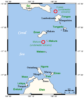
The Shepherd Islands (coordinates 16°48′S 168°30′E / 16.8°S 168.5°ECoordinates: 16°48′S 168°30′E / 16.8°S 168.5°E) are a group of islands lying between the larger islands of Epi and Éfaté, in the Shefa province of Vanuatu. The aggregate land area is 88 square kilometres (34 square miles). At the 2009 census the population numbered 3634.
From north to south, the principal islands are: Laika, Tongoa (Kuwaé), Buniga [mbining]Tongariki, Émaé (Mai), Makura (Emwae), Mataso (Matah), and Monument (Étarik). Émaé and Tongoa are the largest ones islands in the group.
The region includes two submarine volcanoes, Kuwae, and Makura. The islands are principally in the outlines of the calderas of these volcanoes.
The highest of the islands is Émaé, at 644 metres (2,113 feet) above sea level, Tongariki is also above 500 metres (1,640 feet).
Languages
Most of the islands are inhabited by Melanesians like most of Vanuatu, but Émaé is a Polynesian outlier. Other than Emae, on which is spoken a Futunic language, there are, according to Ethnologue, two languages spoken on the other islands: North Éfaté, spoken on Tongoa; and Namakura, spoken on Mataso, Makura, Tongoa, and Tongariki. These are all also spoken on the island of Éfaté, and are closely related to one another and the other languages of Éfaté and central Vanuatu in the language group Central Vanuatu languages.
| Provinces of Vanuatu |  | ||||||||||||||||||||||
|---|---|---|---|---|---|---|---|---|---|---|---|---|---|---|---|---|---|---|---|---|---|---|---|
| Islands and islets | |||||||||||||||||||||||