Sheerwater
| Sheerwater | |
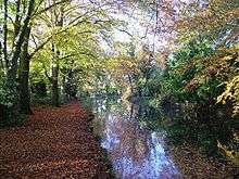
.jpg) Boats on the Basingstoke Canal |
|
.jpg) A small part of Albert Drive with high pines, long-established in the soil type, see Bagshot Formation. |
|
 Sheerwater |
|
| Population | 3,603 [1] |
|---|---|
| OS grid reference | TQ0260 |
| District | Woking |
| Shire county | Surrey |
| Region | South East |
| Country | England |
| Sovereign state | United Kingdom |
| Post town | Woking |
| Postcode district | GU22 |
| Dialling code | 01932 |
| Police | Surrey |
| Fire | Surrey |
| Ambulance | South East Coast |
| EU Parliament | South East England |
| UK Parliament | Woking |
Coordinates: 51°19′48″N 0°31′48″W / 51.330°N 0.530°W
Sheerwater is a residential neighbourhood or small suburb of the Borough of Woking in Surrey, England, with a shared place of worship and occasionally described as a village, between West Byfleet and Horsell.[2] Its border is defined to the north by a gently winding part of the Basingstoke Canal and to the south by the South Western Main Line which passes from cutting level to that of an embankment. The neighbourhood has some commerce and industry to its south, is linear, includes diverse green spaces to north and south and covers 0.92 square kilometres (0.36 sq mi) or 92 hectares (230 acres). Three teenage residents formed the band The Jam in the 1970s while attending Sheerwater's secondary school including Paul Weller – the remainder of the band he led also attended the school.
History and geography
Sheerwater or Sherewater, Pyrford
Sheerwater was also spelt Sherewater until the early 20th century. It was since the Norman Conquest a high sandy heath and notable pond (small lake) of Pyrford.[3][4] Sherewater Pond, on the borders of Pyrford and of Chertsey parishes, was an extensive mere on the high Bagshot Sand, drained and planted at the time of its enclosure, 29 September 1815. Under this process it was allocated into private hands from public common land; a farm was created. John Aubrey then Edward Brayley confused Sherewater with a pond by the Guildford road (A3) on Wisley Common, drained by Peter King, 7th Baron King the Whig politician and writer rather earlier. Sherewater Pond is marked on John Rocque's map (an 18th-century cartographer).[5]
Separation
Creating a distinct identity by having clear buffers, Sheerwater's farm in the mid-nineteenth century became divided from Woodham by the Basingstoke Canal and from Pyrford by the South Western Main Line from London. Sherewater or Sheerwater Farm was approximately where the pond stood in 1911, just north of the railway.[5] The Basingstoke Canal was excavated to form two long curves past the area to keep to lower ground than in Sheerwater's central and southern areas – a lock, rapidly followed by another, allows for a major rise and fall at the north-east corner. This creates a short stretch of water where it is passed over by Sheerwater Bridge. The straight road, using this bridge, forms a boundary of the neighbourhood with West Byfleet and is one of two roads connecting the borough to the A3.
Transformation by planned development
Sheerwater was designed as a new neighbourhood by the London County Council and approved by the local Urban District Council allowing nearly 1,300 homes to be built in the early 1950s and over 5,000 people to settle in the Borough. Users of the Basingstoke Canal see the only water in the estate – the locks allow sufficient rise for Sheerwater, and the terrain of centre and west of Woking with a major fall also across the easternmost stretch immediately below, which has a further four locks through West Byfleet before forming a junction with the Wey Navigation (demarcating the border of Elmbridge).[6]
Sheerwater is a linear settlement. The through road of the estate is Albert Drive which splits into two short one-way streets (Arnold Road and Eve Road) at the south-west end; the latter short streets are no longer within the census definition of Sheerwater. Elevations range between 35m above sea level in the central area and 30m at Sheerwater Bridge on the eastern boundary.
Amenities
On Dartmouth Avenue is the main parade of shops which include two convenience stores, takeaways and a glass/glazing business.[7] The only church in the estate (St Michael's Church) is on Dartmouth Avenue. There is also a Catholic church situated between Albert Drive and Dartmouth Avenue. Closed in 1995.
."The church is a shared Methodist and Church of England congregation.[8][9] Sheerwater has one pub, The Birch and Pines.[10]
Bishop David Brown School is a Secondary School supported by the Anglican community in Sheerwater. Notable former Sheerwater residents and pupils were Paul Weller, Bruce Foxton and Rick Buckler[11] who together with other pupils of the then Sheerwater Comprehensive School formed The Jam.
Garden sizes of housing are smaller compared to neighbouring estates; the largest are in Albert Drive. To allow for vegetable growers a large area of allotments is in Sheerwater, next to the South West Main Line; which having been a cutting in the east corner becomes an embankment by the south-west corner of Sheerwater, thus reducing noise. In architecture, no buildings are listed.[12]
Sport and leisure
Sheerwater has a Non-League football club Sheerwater F.C. who play in the main green buffer area laid out in the north of the estate, The Sheerwater Recreation Ground; directly next to this is an international size oval running track, home to Woking Athletics Club.[13]
In associations Sheerwater has a Scout group[14][15] and a Gardening Association.[16] The verdant, woodchip-lain towpath of the Basingstoke canal is on the Sheerwater side, which increases foot and dedicated cycle access to Woking town centre, to Weybridge and beyond in each direction.
Economy
.jpg)
The Kingswey Business Park has been split into Optimum and Genesis Parks and others. Equally Woking Business Park adjoins the Oriental Road part of central Woking, at the north of Maybury and these fall within the neat boundaries of the Sheerwater suburb. Their businesses generally simplify their address to the post town of Woking, which has significant trade, distribution, professional services, scientific research and industry in medium-size business parks.
Local government
Sheerwater was a ward, electing a councillor in 2001; this was replaced before the 2011 census by Sheerwater and Maybury, electing a councillor.The current councillor is of the Labour Party, Tahir Aziz,shared with Maybury. He is the only Labour councillor in the borough
At Surrey County Council, one of the 81 representatives represents the area within the Woking North division.[17]
At Woking Borough Council. most wards of the borough are deemed appropriate to be represented under the current constitution of councillors by one councillor, which is the case for Sheerwater.[18]
| Election | Member[18] |
Ward | |
|---|---|---|---|
| 2011[19] | Muzaffar Abdullah Ali | Maybury and Sheerwater | |
| Election | Member[20] |
Electoral Division | |
|---|---|---|---|
| 2013 | Ben Carasco | Woking North | |
Demography
In 2001 Sheerwater's population was 3,522 living in 1,420 households.
The United Kingdom Census 2011, reflecting the local authority's expansion of the ward, at a high degree of precision split a new version of Sheerwater in two between local authority 'super output areas' 004E and 004F, the north-west and south-east respectively. The new definition excludes Arnold Road and Eve Road as well as cul-de-sacs next to these, instead being placed within Maybury's super output area.
The proportion of households in the two divisions of Sheerwater who owned their home outright was 10% above and 23% below the national average respectively. The proportion who owned their home with a loan was within 3% of the national average in both areas. The data showed in the second area a higher proportion than average of rented residential property and of social housing relative to the Surrey and national averages.
| Output area | Population | Households | % Owned outright | % Owned with a loan | hectares[1] |
|---|---|---|---|---|---|
| 004E | 2,038 | 694 | 20.5 | 35.4[1] | 50.3 |
| 004F | 1,565 | 627 | 7.2 | 20.9 | 31.4[1] |
References
- 1 2 3 4 Key Statistics; Quick Statistics: Population Density United Kingdom Census 2011 Office for National Statistics Retrieved 17 November 2013
- ↑ "Neighbourhoods map" (PDF). Retrieved 18 November 2012.
- ↑ Map of the Hundred of Godley H.E. Malden below
- ↑ H.E. Malden (editor) (1911). "The Godley Hundred: Introduction and map". A History of the County of Surrey: Volume 3. Institute of Historical Research. Retrieved 17 November 2013. illustrative map of Godley Hundred by H.E. Malden
- 1 2 H.E. Malden (editor) (1911). "Parishes: Pyrford". A History of the County of Surrey: Volume 3. Institute of Historical Research. Retrieved 17 November 2013.
- ↑ Grid Reference Finder distance tools
- ↑ "Contact Sheerwater Glass". Sheerwaterglass.co.uk. Retrieved 18 November 2012.
- ↑ "The Church in Sheerwater". Window on Woking. Retrieved 18 November 2012.
- ↑ St Michael's Shared Church The Church of England
- ↑ "Birch and Pines, Sheerwater, Surrey, GU21 5PJ – pub details#". Beerintheevening.com. Retrieved 18 November 2012.
- ↑ "thejamfan.net". thejamfan.net. 1 September 1955. Retrieved 18 November 2012.
- ↑ OS Map with Listed Buildings and Parks marked
- ↑ "wokingac.com". Woking Athletics Club. Retrieved 18 November 2012.
- ↑ "Sheerwater Scout Group". Window on Woking. Retrieved 18 November 2012.
- ↑ "Home". Sheerwater Scouts. Retrieved 18 November 2012.
- ↑ "Sheerwater Gardening and Allotment Association". Window on Woking. Retrieved 18 November 2012.
- ↑ Electoral Divisions Surrey County Council. Retrieved 6 November 2013
- 1 2 Your local councillors Woking Borough Council. Retrieved 6 November 2013
- ↑ Four-yearly election results, 2011 Woking Borough Council. Retrieved 6 November 2013
- ↑ Your Councillor Surrey County Council. Retrieved 6 November 2013
| Towns, villages and hamlets | 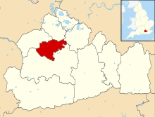 | ||||||
|---|---|---|---|---|---|---|---|
| Parks | |||||||
| Places of worship | |||||||
| Education | |||||||
| Transport | |||||||
| Buildings and structures | |||||||
| Sport |
| ||||||